Severe thunderstorm watch issued for Wake County until 8 p.m.
Wake County faced a severe thunderstorm watch until 8 p.m. Tuesday, with 60 mph wind gusts already prompting a warning in the northeast.
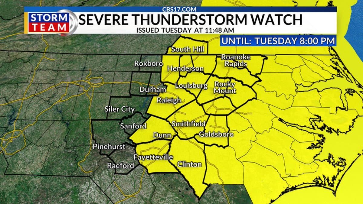
Damaging winds were the main concern for Wake County as storms moved east Tuesday, with the National Weather Service in Raleigh keeping the county under a severe thunderstorm watch until 8 p.m. The biggest risk fell to the afternoon and evening commute, when storms were expected to strengthen ahead of an approaching cold front.
The watch was issued at 11:48 a.m. Tuesday for 14 counties in central North Carolina, including Wake County. Forecasters said damaging wind gusts were the primary threat, and they did not rule out an isolated tornado or two as the line of storms developed and pushed offshore later in the evening.

Wake County was also placed in a Slight Risk, level 2 of 5, for severe thunderstorms. The weather service said spotter activation may be needed, a sign that conditions were serious enough to require closer monitoring from trained observers across the region.
By 12:11 p.m., the weather service had already issued a severe thunderstorm warning for northeastern Wake County and nearby areas, including Wake Forest, Wendell, Rolesville and Zebulon. That warning cited radar-indicated wind gusts of 60 mph and penny-size hail, with the storm line moving northeast at 25 mph.
For residents in those communities, the most immediate concerns were tree damage, scattered power outages and hazardous driving on open roads where gusts could hit suddenly. High-profile roads, school pickup routes and outdoor work sites were among the places most likely to be affected first as the line of storms crossed the county.
The forecast for Wake County called for showers and thunderstorms likely Tuesday afternoon, with highs in the upper 80s. The broader outlook pointed to a hotter stretch later in the week, with heat index values expected to reach 100 to 105 over the upcoming weekend, adding another layer of stress after the storms moved out.
The setup made Tuesday a day to stay weather-aware through the evening, especially in northeastern Wake County and across the corridor toward Franklin County, Johnston County and Nash County. With severe weather already on the board before lunchtime, the strongest impacts were expected to come before 8 p.m. as the line of storms swept east.
This article was produced by Prism’s automated news system from verified source data, official records, and press releases, then run through automated quality and moderation checks before publishing. The system is built and supervised by the people who set the standards it runs under. Read our full AI policy.
Know something we missed? Have a correction or additional information?
Submit a Tip