Alaska fjord landslide unleashed second-highest tsunami ever recorded
A Tracy Arm landslide sent a 1,580-foot tsunami run-up racing down a remote fjord, making it the second-highest ever recorded. The near-miss sharpened alarms about warming-driven slope failure.
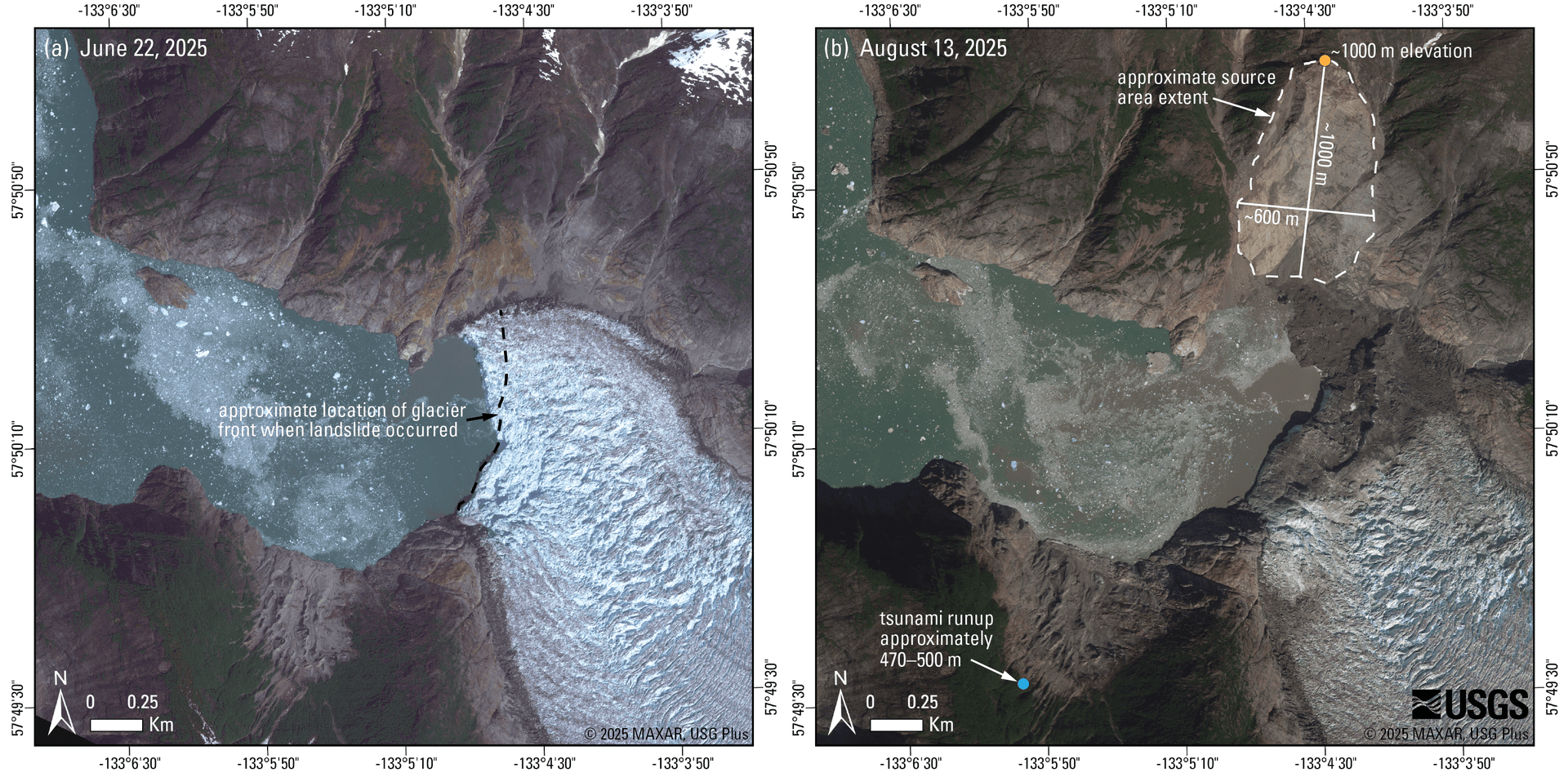
A landslide in Tracy Arm Fjord sent a tsunami walling up fjord walls in southeastern Alaska and produced a run-up of about 1,580 feet, or 481 meters, making it the second-highest ever recorded. The slide struck near South Sawyer Glacier in Tongass National Forest, about 80 miles south-southeast of Juneau, and turned a place known for glaciers, cliffs and tourism into the site of one of the most extreme slope failures on record.
The U.S. Geological Survey said the landslide failed into the water at 05:26 AKDT, or 13:26 UTC, on August 10, 2025. No injuries or fatalities were reported, in part because the fjord was quiet that early in the morning. The agency said kayakers camped at Harbor Island near the mouth of Tracy Arm reported gear swept away by a wave, while NOAA’s Juneau tide gauge recorded a maximum wave height of 36 centimeters above tide and detected waves for hours.
Scientists later pieced together the scale of the event. The Alaska Earthquake Center initially estimated that more than 100 million cubic meters of debris came down, while a Science study put the landslide volume at greater than 64 million cubic meters. That study said the initial breaking wave rose to about 100 meters high and traveled more than 70 meters per second. It also found that the slide produced global long-period seismic waves equivalent to a magnitude 5.4 earthquake and set off a fjord seiche that lasted as long as 36 hours.
The same research found the landslide was preceded by several days of microseismicity that intensified until about an hour before failure. Field surveys in October 2025 documented a run-up of about 1,580 feet roughly 2 miles from the slide, leaving stripped vegetation on the fjord walls and placing the Tracy Arm event just behind the 1958 Lituya Bay megatsunami, which reached 1,730 feet. University of Alaska Fairbanks scientists said it was the first comprehensive analysis of the Tracy Arm disaster and warned that similar large-scale failures are becoming more likely as glaciers retreat and permafrost degrades across the North.
The warning reaches well beyond one fjord. More than 20 vessels, including large cruise ships carrying thousands of passengers, typically move through Tracy and Endicott arms each summer, and several cruise lines have already adjusted 2026 itineraries to avoid Tracy Arm. The event exposed a hazard that can unfold in remote terrain with little immediate warning, then register later through instruments, field surveys and the damage left behind.
This article was produced by Prism’s automated news system from verified source data, official records, and press releases, then run through automated quality and moderation checks before publishing. The system is built and supervised by the people who set the standards it runs under. Read our full AI policy.
Did this article answer your question?