Animas River Walk in Farmington: Trails, access points, safety tips, volunteer resources
farmington’s Animas River Walk spans 8+ miles along the river with parks, birding, ADA-accessible loops and volunteer partners; maps and contacts (505-599-1400) help plan visits.

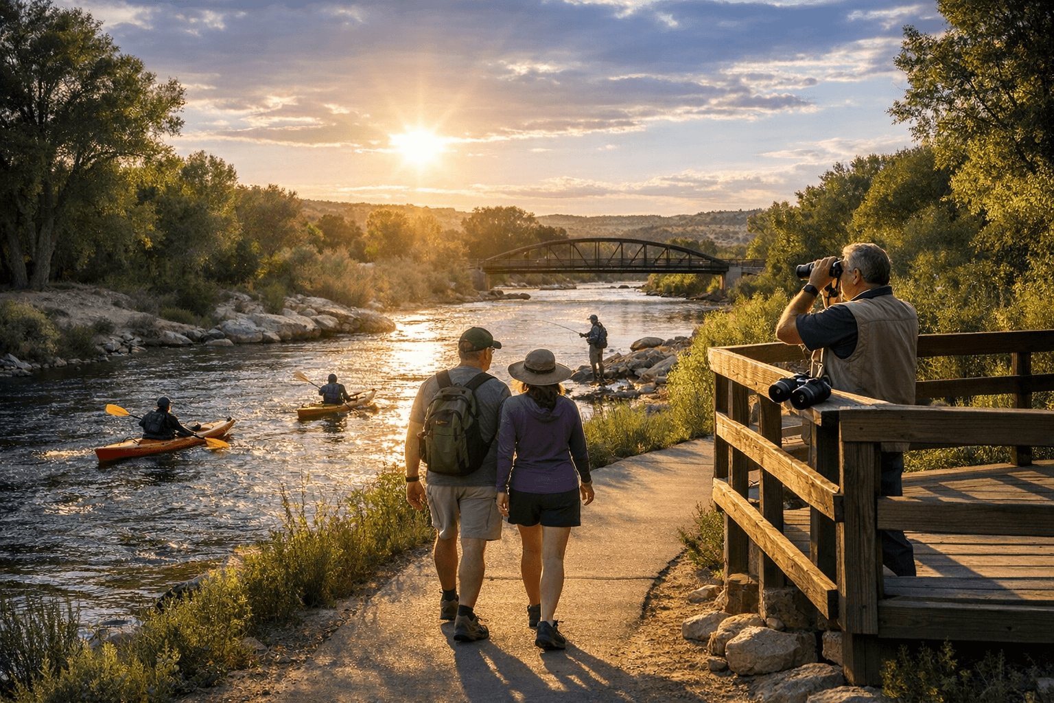
Farmington’s Animas River Walk is the city’s primary riverside trail system, running more than 8 miles along the Animas River through parks, playgrounds, trailheads and open space. The corridor links visible attractions — Berg Park (access at San Juan Blvd. and Scott Ave.), Animas Park, the Animas River Whitewater Park, All Veterans Memorial Plaza and the Riverside Nature Center — and is designated as a certified National Recreational Trail. For quick information or questions about city-managed segments, call 505-599-1400 or download the Farmington Recreation Trails Map and Farmington Recreation Trail Map 2.
Trail surfaces and how they feel underfoot The Animas River Walk in Farmington is a mixed-surface system: paved sections for strollers and bikes, dirt and wood-chip stretches through shaded areas, and cobblestone paths in some park plazas. That variety supports year‑round uses — walking, running, biking and birding — and explains why more than 100 bird species have been identified across the system and adjoining parks. Riverside Nature Center supports birding on the walk by offering a bag of free bird food and areas where you can feed ducks and geese as you walk along the river.
Key access points, parking and maps Berg Park is a popular entry point; use the intersection of San Juan Boulevard and Scott Avenue to reach that access. Animas Park and multiple trailheads serve other neighborhoods. Farmington’s downloadable trail maps (Farmington Recreation Trails Map and Trail Map 2) are the best resource for planning routes and locating parking. Neighboring municipalities also offer access options: Durango’s municipal Animas River Trail and Aztec’s Riverside Park Loop connect to the broader river corridor geographically, but they are separate systems administratively and in how they are managed.
Accessibility, amenities and fitness features Some segments are explicitly ADA‑accessible. In Aztec, the Riverside Park Loop’s concrete segment along the river and the Riverside‑Hartman Pedestrian Bridge allow for ADA use along most of the river’s edge. Durango’s municipal trail is also described as wheelchair accessible. Aztec’s Riverside Park Loop additionally includes four fitness stations donated by San Juan Regional Medical Center — Push‑Off, Body‑Pull, Sit‑Up and Body‑Tuck — that add low‑impact strength stops to a riverside walk.
Activities to plan around The corridor supports a range of activities across jurisdictions: Farmington’s trails are used for walking, running, biking and bird watching; Aztec highlights fishing, hiking, bicycling and family recreation on the Riverside Park Loop; Durango’s river walk accommodates walking, biking, inline skating, mountain biking and cross‑country skiing. The US Forest Service’s Animas River Trail — a backcountry route in the San Juan National Forest — is distinct: it serves day hikers, backpackers and stock riders and offers riverbank fishing (rated good for brook, rainbow and cutthroat trout).
Backcountry caution: USFS rules and access If you plan to take the Animas River Trail in the national forest, note the US Forest Service rules and logistics. The backcountry Animas River Trail is non‑motorized and explicitly prohibits e‑bikes; it follows riverbanks with steep canyon walls, numerous good campsites and horse traffic — “expect to see horse traffic and be respectful of other trail users.” Water is available from the Animas River but purification is recommended before drinking. Access to this trail is only from Purgatory Flats Trail #511 or Needle Creek Trail #504; the FS gives specific directions to Purgatory Flats (~26 miles north of Durango on U.S. 550, across from Purgatory Ski Resort) and advises using the Needleton train stop and Needle Creek Trail to reach the junction. For questions about that backcountry corridor, contact the Columbine Ranger District Office at 367 Pearl Street, Bayfield, CO 81122, phone (970) 884‑2512 (office hours listed as Friday only, 10:00am–4:30pm). The Forest Service page was last updated August 29, 2025.
How Farmington connects to neighboring Animas corridors The Animas River Walk sits in a chain of riverfront corridors that include Aztec upstream and Durango upriver in Colorado. Aztec’s Riverside Park Loop creates a scenic loop around Riverside Park and links to Hartman Park via the Riverside‑Hartman Pedestrian Bridge. Aztec planning documents describe a proposed 0.25‑mile trail segment that would follow an irrigation ditch from the Ruins Road Trail near a proposed Bridge Park, pass through a cottonwood bosque to meet the Riverside Trail and continue to Townsend Wildlife Nature Refuge. That proposed segment would be accessible from Chaco Street and the Chaco‑Main‑Llano Walk and would pass underneath Chaco Street and Aztec Boulevard to offer an alternative to crosswalks. Aztec officials also planned an access point near the parking area to act as a final pullout for rafters leaving the city; the parking and river access would be fenced off from the refuge to limit vehicular wandering. Several Aztec elements remain contingent on easements and agreements with Aztec Ruins National Monument, the Eledge Ditch Association and private property owners, and land ownership details can be checked using San Juan County Assessor records.
Durango and usage benchmarks worth noting Durango’s municipal Animas River Trail, while a separate local system, offers useful benchmarks for riverwalk planning: it hugs the river for just over 9 miles, passes through downtown and a half‑dozen public parks, and is credited with heavy daily use. Parks and Recreation Director Cathy Metz said, “We have surveys that show that 90 percent of the people who live in Durango use the trail,” and local estimates put daily users at 1,000 to 1,500. The Durango trail also rises gently from 6,371 to 6,565 feet in elevation and includes interpretive signs and vintage streetlights.
Volunteer groups, donors and who runs what Farmington’s trail growth and programming involve municipal partners and community organizations — specifically the City of Farmington and the River Reach Foundation. Donors play a role in Aztec’s facilities: San Juan Regional Medical Center funded the four fitness stations on the Riverside Park Loop. For Farmington trail maintenance, mapping and volunteer coordination, contact the City of Farmington at 505‑599‑1400 or connect with the River Reach Foundation for organized cleanups and programming.
- Carry and use water purification if you plan to drink river water on backcountry segments; the USFS explicitly recommends purification.
- Expect and yield to horse traffic on USFS backcountry trails; hikers and riders share the route.
- Use ADA‑accessible concrete sections and the Riverside‑Hartman Pedestrian Bridge for barrier‑free routes.
- Plan parking around named parks: Berg Park (San Juan Blvd. & Scott Ave.), Animas Park and other trailheads; Durango’s park list (Dallabetta, Santa Rita, Schneider, Rotary and Animas City Park) shows how parking nodes can anchor access in a riverwalk network.
- If rafting downstream from Aztec, be aware of planned pullout points and fenced parking areas that will control vehicle access when those projects are completed.
Practical safety and trail tips
Looking ahead Farmington’s certified National Recreational Trail designation, the River Reach Foundation’s involvement and municipal mapping tools make the Animas River Walk a durable local asset. Adjacent plans in Aztec to improve loops, river access and educational plant/wildlife signage — and the substantial daily usage documented in Durango — suggest a regional push to balance recreation, conservation and access. Use the downloadable Farmington trail maps and the city phone (505‑599‑1400) to plan routes, and follow the USFS guidance and Columbine Ranger District contact when moving into backcountry segments; incremental projects and easement negotiations upstream mean access and amenities along the Animas corridor are likely to evolve in the coming years.
Know something we missed? Have a correction or additional information?
Submit a Tip