China Maps Pacific, Indian, Arctic Seabeds in Vast Submarine Warfare Operation
A Chinese research vessel sailed back and forth near Taiwan, Guam, and the Indian Ocean for two years. Nine naval experts say the data collected is crucial for submarine warfare against the U.S.

The Dong Fang Hong 3 spent two years crisscrossing waters the U.S. military considers vital to Pacific defense. The research vessel, operated by Ocean University of China, spent 2024 and 2025 sailing back and forth in the seas near Taiwan and the U.S. stronghold of Guam, and around strategic stretches of the Indian Ocean. It was not alone.
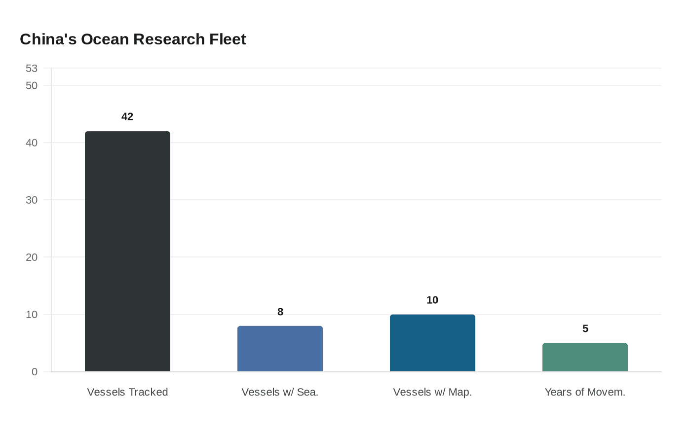
The Dong Fang Hong 3 is part of a broader ocean mapping and monitoring operation involving dozens of research vessels and hundreds of sensors. Reuters examined Chinese government and university records, including journal articles and scientific studies, and analyzed more than five years of movement by 42 research vessels active in the Pacific, Indian, or Arctic oceans using a ship-tracking platform built by New Zealand company Starboard Maritime Intelligence.
At least eight of the vessels tracked have conducted seabed mapping, while another 10 have carried equipment used for mapping, according to a review of Chinese state media articles, vessel descriptions published by Chinese universities, and press releases by government organizations. The method for identifying mapping behavior is precise: research vessels map the sea floor while traveling back and forth in tight lines, and the tracking data shows that type of movement by the vessels tracked across large sections of the Pacific, Indian and Arctic oceans.
While the research has civilian purposes, including surveying covering fishing grounds or areas where China has mineral prospecting contracts, it also serves a military one, according to nine naval-warfare experts who reviewed the findings. The geographic focus of the effort makes clear what the military targets are. The ship-tracking data show that China's seabed-surveying effort is focused in part on militarily important waters around the Philippines, near Guam and Hawaii, and near U.S. military facilities on Wake Atoll in the north Pacific.
In October 2024, the Dong Fang Hong 3 checked on a set of powerful Chinese ocean sensors capable of identifying undersea objects near Japan, and visited the same area again the following May. In March 2025, it criss-crossed the waters between Sri Lanka and Indonesia, covering approaches to the Malacca Strait, a critical chokepoint for maritime commerce.
The implications alarmed senior U.S. defense officials. In testimony to a congressional commission, Rear Admiral Mike Brookes, the commander of the U.S. Office of Naval Intelligence, said China had dramatically expanded its surveying efforts, providing data that "enables submarine navigation, concealment, and positioning of seabed sensors or weapons," and called potential military intelligence collection by Chinese research vessels "a strategic concern." Peter Scott, a former chief of Australia's submarine force, put it plainly: the vessels' survey data "would be potentially invaluable in preparation of the battlespace" for Chinese submarines.
Around 2014, Wu Lixin, a scientist at Ocean University, proposed an ambitious effort to create a "transparent ocean" by deploying sensors that would give China a comprehensive view of water conditions and movement through specific areas. The proposal quickly received at least $85 million in support from the Shandong provincial government. That early investment now appears to have matured into a global operation.
Zhou Chun, an Ocean University researcher who oversees the Indian and Pacific ocean sensor arrays, was quoted last year in an Ocean University press release as saying that his work had shown him "the rapid development of my country's maritime defense and military capabilities." He did not respond to questions. Going forward, Zhou pledged to "transform the most advanced scientific and technological achievements into new types of combat capabilities for our military at sea."
China's civilian survey ships also sometimes disable tracking, meaning the campaign may go further than tracking data alone can determine. This is the first time the full extent of China's mapping and monitoring across the Pacific, Indian and Arctic oceans has been reported.
Know something we missed? Have a correction or additional information?
Submit a Tip

