Hurricane Genevieve rapidly strengthens to Category 5 over Pacific
Genevieve briefly hit Category 5 with 160 mph winds far offshore, turning a landfall-free storm into a major Pacific hazard for surf, shipping and alerts.

Genevieve briefly reached Category 5 strength in the eastern Pacific with maximum sustained winds of 160 mph while staying far from land. Forecasters said the storm was not expected to make direct landfall, but its rapid jump in intensity made it a close watch for coastal communities, mariners and emergency managers across the Pacific.
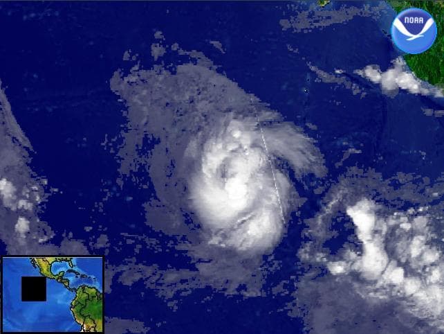
The National Hurricane Center in Miami said Genevieve hit its peak strength as it churned far from land in the Pacific Ocean. NOAA satellite imagery used in coverage showed the hurricane off the southwest coast of Mexico on Sunday, July 26, 2026, alongside Hurricane Fausto, underscoring how active the basin was as Genevieve organized and strengthened.
The speed of the upgrade drew as much attention as the storm’s peak wind speed. FOX Weather said Genevieve became the Northern Hemisphere’s first major hurricane of the 2026 season, and other coverage described it as the first Category 5 hurricane in the Eastern Pacific since Hurricane Kristy in 2024. The National Hurricane Center kept issuing public advisories, forecast advisories, wind-speed probabilities and cone graphics as the storm evolved, a standard response when a system is strengthening quickly enough to leave little margin for error.
That monitoring mattered even without a direct landfall threat. A hurricane that remains offshore can still drive dangerous surf, rip currents, outer-band rain and marine hazards over a wide area, and large Pacific hurricanes can disrupt shipping lanes and fishing activity. Another active storm, Hurricane Fausto, was also sending large surf toward Hawaii at the same time, showing how multiple systems can produce broad coastal and ocean risks even when the center stays at sea.
Genevieve also fit a larger seasonal pattern that meteorologists track closely in July, when warm waters can feed rapid intensification and shift a storm from manageable to dangerous in a short window. The difference between an offshore hurricane and a landfalling one can come down to a small change in track, which is why coastal officials, forecasters and the public watch these advisories so closely even when the center never reaches shore. A separate National Hurricane Center tropical cyclone report shows the name Genevieve was also used for a 2014 storm, but this Pacific hurricane was a different system entirely.
This article was produced by Prism’s automated news system from verified source data, official records, and press releases, then run through automated quality and moderation checks before publishing. The system is built and supervised by the people who set the standards it runs under. Read our full AI policy.
Did this article answer your question?