Mauna Loa Seismicity Rises Slightly; GPS Shows Summit Reservoir Refilling
Seismic activity beneath Mauna Loa rose slightly in January, and GPS measurements show summit reservoir refilling - important for residents as ongoing monitoring continues.

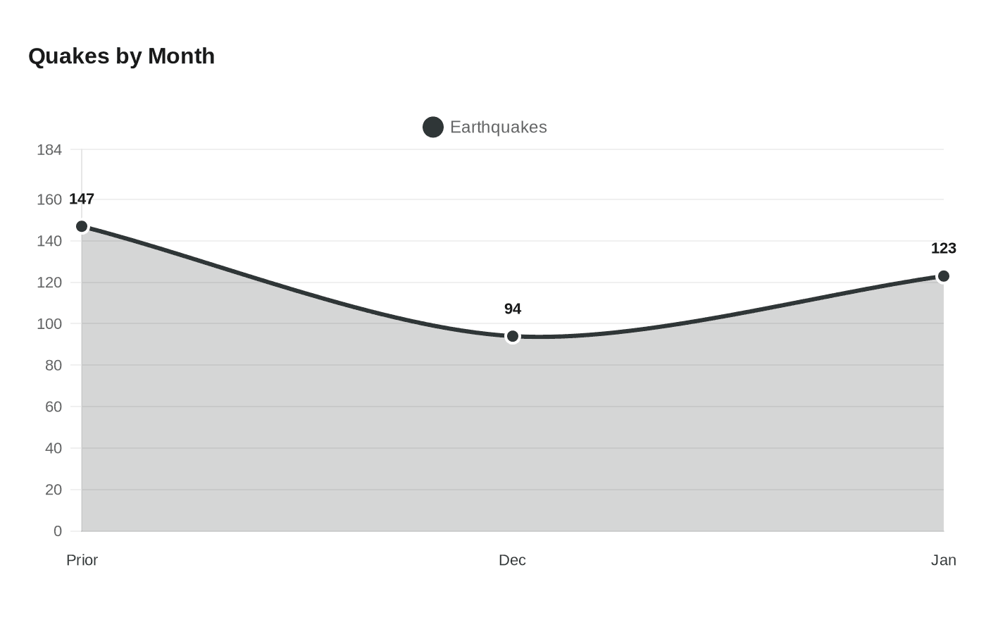
Seismic activity beneath Mauna Loa increased modestly in the January reporting period, the USGS Hawaiian Volcano Observatory said, recording 123 earthquakes beneath the volcano’s summit region compared with 94 in December. The uptick did not prompt a change in the observatory’s hazard status; the Volcano Alert Level remains NORMAL and the Aviation Color Code is GREEN.
The Observatory reported a "tight clustering of events under Mokuʻāweoweo and upper Southwest Rift Zone early in the month," a pattern it described as a continuation of elevated activity from the end of December. Volcanoes.USGS also noted that "earthquake production rates increased, later in the month, under the caldera and upper-SWRZ" and described a shorter, earlier pulse of seismicity: "There was a relatively short-lived (< 1 day) activity that elucidated the (pre-2022 eruption) northwest cluster on 2025-12-17."
GPS instruments on Mauna Loa provide complementary insight. The USGS wrote that "Data from Global Positioning System (GPS) instruments on Mauna Loa show variable rates of inflation at the summit over the past six months." Another HVO wording posted on the Volcanoes.USGS page observed that "Data from Global Positioning System (GPS) instruments on Mauna Loa show a lower inflation beneath the summit compared to the previous six months. These rates are normal as the volcano recovers from the 2022 eruption and magma replenishes the reservoir system." Taken together, those statements describe short-term variability while indicating that magma is replenishing summit storage following the 2022 eruption.
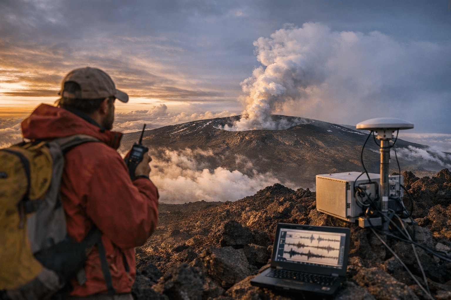
The Observatory’s monthly update includes routine field work and imagery. "On Tuesday, December 23, USGS Hawaiian Volcano Observatory scientists completed a helicopter overflight of Mauna Loa's summit and upper rift zones. This photo—captured looking north-northeast—shows South Pit (foreground) and Moku‘āweoweo caldera (middle distance) with Mauna Kea looming behind," the USGS caption says; the photo credit is USGS photo by M. Zoeller. Mauna Loa’s summit elevation is 13,681 ft (4,170 m), located at 19°28'30" N, 155°36'29" W.
For Big Island residents, the numbers matter more as a trend than as a single-month spike. December had seen a lull that reduced seismicity by about 40 percent from the prior month, according to the Volcanoes.USGS account, which contrasted December’s 94 events with 147 the month before. The current pattern of clustered earthquakes and GPS inflation signals a refilling process rather than imminent eruption, but it is precisely the kind of activity that keeps scientists on alert and communities tuned to official updates.
The USGS continues routine monitoring; HVO data and monthly updates will show whether the clustering and inflation stabilize or evolve. For now, Mauna Loa’s condition remains under watchful study, and residents and visitors should follow official HVO and county channels for any change in advisories or access around the summit and rift zones.
Know something we missed? Have a correction or additional information?
Submit a Tip