NOAA to resume outlooks May 15; forecasts predict roughly 12–14 named storms
NOAA will restart regular Tropical Weather Outlooks May 15; private forecasts cluster near 1991–2020 averages, but experts urge communities to prepare now.

NOAA will resume regular Tropical Weather Outlooks on May 15, 2026, signaling the start of intensified operational monitoring roughly two weeks before the Atlantic hurricane season opens June 1. Tropical Storm Risk and a private firm’s preliminary outlook issued this winter place the 2026 season near long‑term averages, but forecasters and emergency managers emphasize persistent uncertainty tied to evolving ocean patterns and warm Atlantic waters.
The National Hurricane Center web pages currently note, "There are no tropical cyclones in the Atlantic at this time. The Atlantic hurricane season runs from June 1st through November 30th." The NHC also posts a procedural notice: "Tropical Weather Outlook Issuance will resume on May 15th or as necessary." Those operational dates set the public window for daily tropical monitoring ahead of summer.
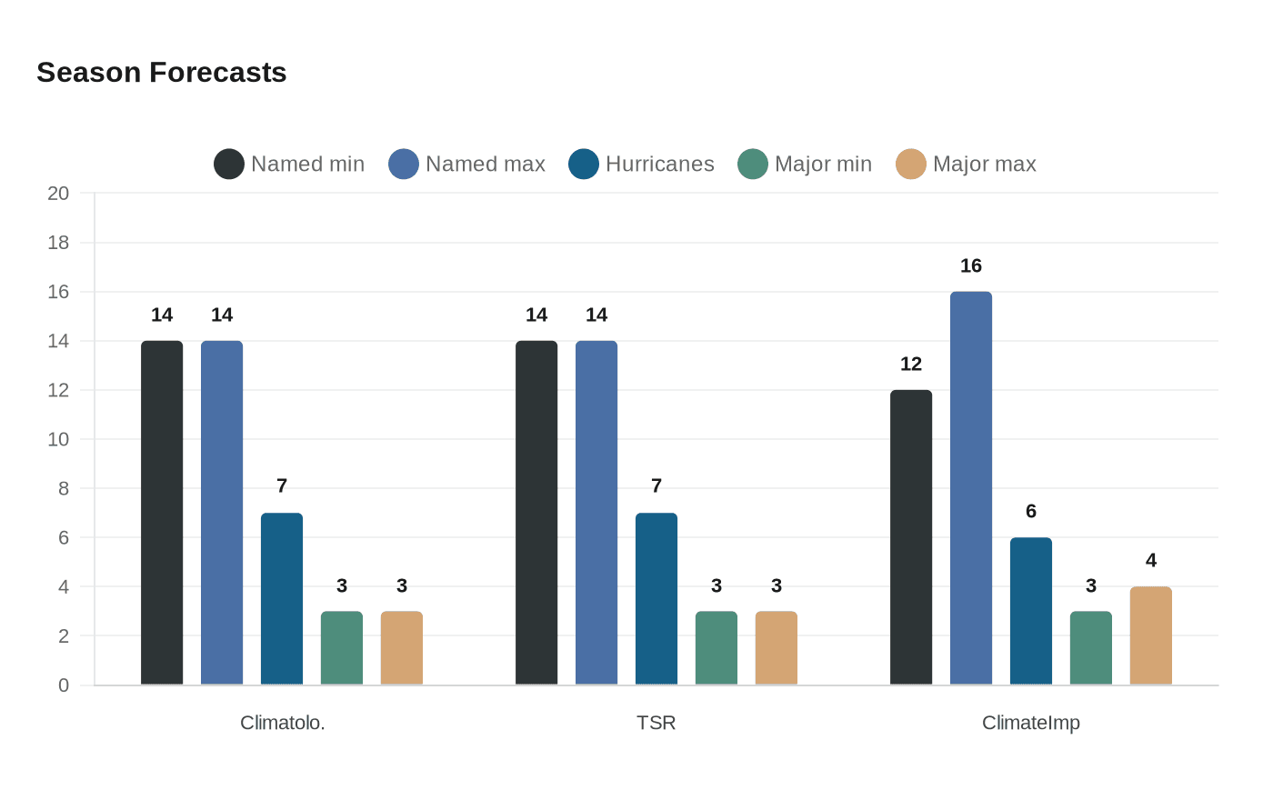
Preseason forecasts issued in December cluster near the 1991–2020 climatology of about 14 named storms, 7 hurricanes and 3 major hurricanes. Tropical Storm Risk on Dec. 11, 2025 projected 14 named storms, 7 hurricanes and 3 major hurricanes with an accumulated cyclone energy index near 125, a forecast TSR described as "a near-normal season" while noting "historically low certainty in this forecast." A separate preliminary product from Climateimpactcompany on Dec. 1, 2025 put activity at 12–16 tropical storms, about 6 hurricanes and 3–4 intense hurricanes with an ACE range of 105–140. Its authors wrote, "The preliminary outlook for tropical cyclone season activity during 2026 for the North Atlantic basin is based on a reasonable risk of El Nino and continued anomalous warming of the North Atlantic basin although the deep tropics are closer to normal SSTA (Fig. 5)." Climateimpactcompany added that "The activity level is similar with 2025, slightly below the 30-year normal, and much below the 2016-24 active period climatology."

A central wild card is the El Niño–Southern Oscillation. NOAA projects a transition from La Niña to ENSO-neutral in February through April 2026, with neutral conditions likely to persist through the Northern Hemisphere summer. Forecast groups cite that shift as capable of increasing upper-level wind shear over the tropical Atlantic, a factor that can suppress storm formation, even as anomalously warm North Atlantic sea surface temperatures offer a countervailing boost. TSR singled out "potentially moderate El Niño conditions arising in mid to late summer 2026, along with a reasonable certainty of warmer-than-average sea surface temperatures (SSTs) for the season."
Federal tools and communications have already adapted to give communities more warning time. EcoFlow and other observers highlight that "NOAA’s Climate Prediction Center’s Global Tropical Hazards outlook has extended its advance notice from 2 weeks to three weeks to also allow for more preparation time." The Weather Prediction Center’s experimental Probabilistic Precipitation Portal now offers forecasts aimed at flash flooding and heavy rainfall up to three days ahead, giving emergency managers finer short-term guidance.
The constellation of actors involved is broad: "U.S. federal meteorological agencies and private forecasting groups (NOAA, National Hurricane Center, Weather Prediction Center, and major weather services), plus emergency management officials in coastal states." What: A first public outlook and analysis for the 2026 Atlantic hurricane season w [truncated]. That mix of agencies and private forecasters will determine how seasonal projections translate into preparedness funding, evacuation plans and infrastructure decisions this spring.
Preparedness advisers stress that near‑average seasonal numbers do not eliminate risk. As EcoFlow put it, "While this increases upper-level wind shear (theoretically meaning a milder season), other factors are at play, and conditions can change, so always prepare for a hurricane." For policymakers and local officials, the policy implications are clear: use the extended CPC lead time and new precipitation tools to accelerate readiness, prioritize resiliency investments for coastal communities, and maintain public communications before the NHC begins daily outlooks in mid‑May.
This article was produced by Prism’s automated news system from verified source data, official records, and press releases, then run through automated quality and moderation checks before publishing. The system is built and supervised by the people who set the standards it runs under. Read our full AI policy.
Did this article answer your question?


