Reading Florida Keys Mile Markers, Navigating U.S. 1 Through Monroe County
Amy Slate’s Amoray Dive Resort sits at MM 104.3, bayside Key Largo; the green Mile Marker signs along U.S. 1 are the local language for directions, parks, boat ramps and the Southernmost Point.
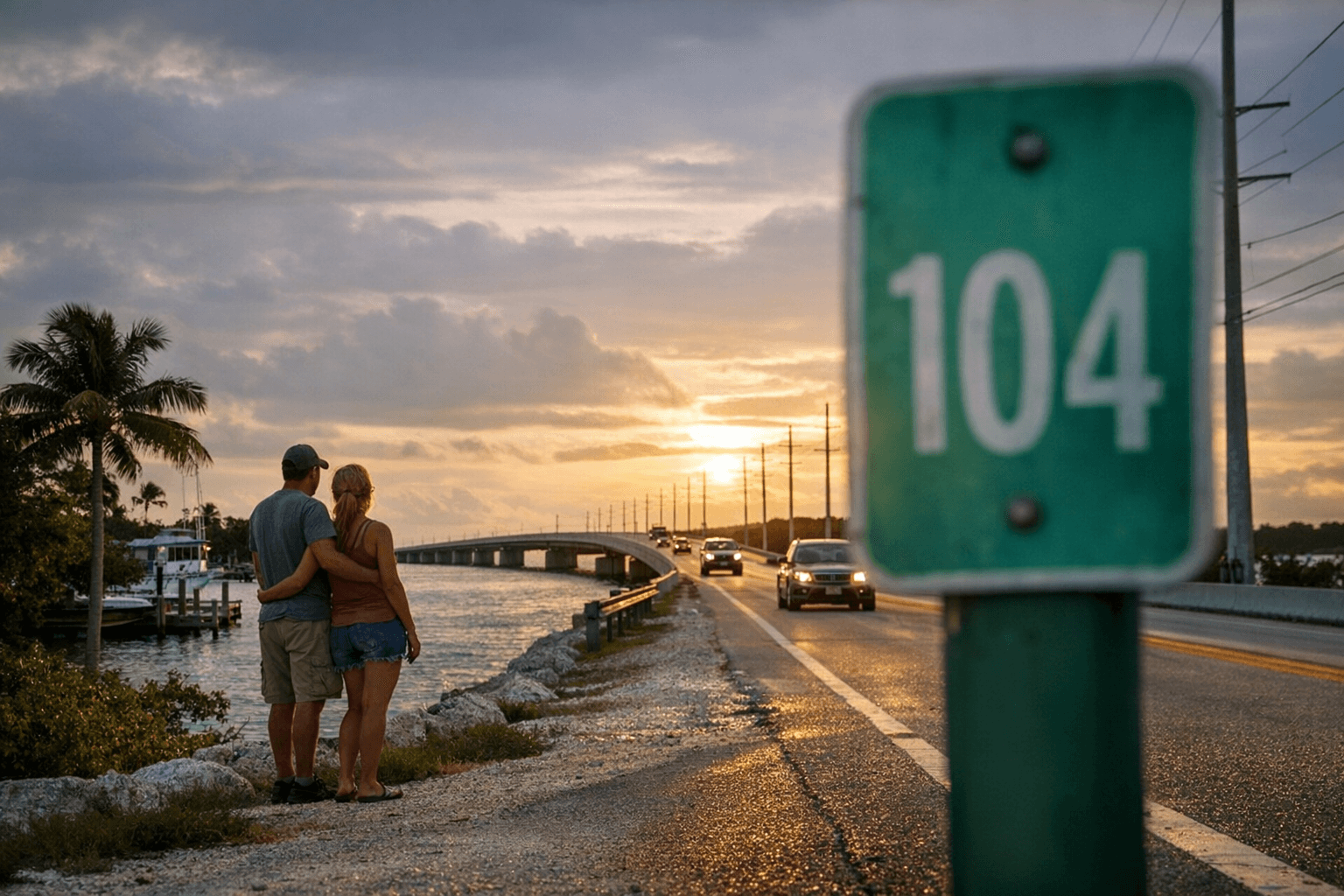
Amy Slate’s Amoray Dive Resort sits at MM 104.3, bayside Key Largo, a practical demonstration of how locals and businesses use Mile Markers to give directions along U.S. 1. The Mile Marker system runs along the Overseas Highway, the first 113 miles of U.S. 1 built on Henry Flagler’s railroad bed, and counts down to MM 0 at the Southernmost Point in Key West, near the Monroe County Courthouse at 500 Whitehead Street.
How the mile-marker system works The Mile Marker signs are small green placards that count down to zero along the Overseas Highway and are read as precise coordinates by residents, emergency responders, real estate listings and tour operators. Markers also indicate orientation: bayside refers to the west side of U.S. 1 and oceanside refers to the east, a useful distinction when someone tells you to meet at a bayside restaurant or an oceanside boat ramp. Guides and local businesses routinely attach short descriptions to specific MMs so a single number such as MM 104.5 can point to both a kayak outfitter and a Monroe County park.
- Memorize whether a location is bayside or oceanside — emergency crews and marina staff use that language.
- Note nearby MM numbers when calling for help or arranging pickups; MM 0 is the Southernmost Point, MM 112.5 marks the Monroe County line.
- Use pullouts and designated parks for stopping: the Overseas Highway has many official pullovers for fishing, kayaking and sunset cocktails.
Navigation and driving tips you can use today
“Veer left (east) off the Overseas Highway to north Key Largo. This alternate route crosses a toll bridge. Merges back with U.S. 1 at Mile Marker 106.” That succinct instruction is the clearest example in local navigation notes: when a guide tells you to take the east route to north Key Largo expect a toll bridge and a reunion with U.S. 1 at MM 106. Watch for off-ramps as well: Gilbert’s Resort is flagged with a specific warning to “Watch for the off-ramp just before the Jewfish Creek Bridge,” making MM attention essential when you are driving at sunset and traffic is heavy. Practical tips:
Mile-marker highlights, north to south MM 112.5 denotes the Monroe County line, the numerical gateway to the Keys. A few miles south, MM 110.8 points to a bayside launch, “KAYAK— Little Blackwater Sound Boat Ramp,” a frequent pickup and launch point for anglers and paddlers. At MM 108.5 you will find Gilbert’s Resort, described as a “Classic Keys pit stop with the largest waterfront tiki bar in the Keys,” with a note to watch for its off-ramp just before the Jewfish Creek Bridge. Islands Plaza at MM 105.3 carries a commercial update in local listings: “Former Winn-Dixie being converted to Aldi Supermarket,” a development to watch if you need grocery options in Key Largo.
The MM 104.5 cluster is a functional hub: two co-located entries are explicit, “KAYAK— Florida Bay Outfitters. Small fee to launch. The friendly folks here will give you advice on kayak routes and rent kayaks, paddle boards,” and “PARK — Rowell’s Waterfront Park. This former marina continues to be developed as a Monroe County park with a swimming hole, kayak launch, picnic tables and restrooms.” Those two entries, both at MM 104.5, highlight how a single marker can point to both private outfitters and county facilities. Nearby MM 104.3 lists Amy Slate’s Amoray Dive Resort (bayside) while MM 104.2 identifies Keys Palms RV Resort on the bayside, a useful cluster for visitors staging dive or kayak trips.
Around MM 98.0 a variety of community anchors appear: Landings of Largo, a Moose Lodge on the oceanside, the Everglades Park Ranger Station bayside, First Baptist Church oceanside, Shell World at a center road location, and Rock Harbor Club bayside. The MM 95–100 corridor carries local history: this area was once called Rock Harbor with a small railroad depot; after the 1948 Humphrey Bogart-Lauren Bacall film Key Largo local leaders renamed the post office Key Largo in 1952. Small, hometown businesses still show up on the markers: Harriette’s Diner at MM 95.8 is recorded as a popular locals’ eatery offering “home cookin’,” and MM 95.2 marks the Florida Keys National Marine Sanctuary building.
Further south, MM 94.8 records a seaside community and the 1900s Thompson line packing house, and MM 93.6 lists the Florida Keys Wild Bird Center on the gulf side with a boardwalk through mangrove. In the Lower Keys, MM 30.3 identifies the National Key Deer Refuge, which spans over 8,000 acres of salt marshes, mangroves and upland habitat and offers hiking trails, wildlife viewing and scenic drives for anyone interested in conservation and landscape-scale wildlife management. Finally, MM 0 marks the Southernmost Point in the continental United States, the anchor for drivers who followed U.S. 1 the full Overseas Highway distance into Key West.
Parks, launches and outdoor operations Pennekamp State Park is singled out in guide material as a conservation success that preserves one of the largest tracts of West Indian tropical hardwood hammock in the United States, with picnic tables and two short hikes, a two-mile nature trail and a one-mile loop, plus an additional four miles available for those who fill out a back-country permit form. Rowell’s Waterfront Park, noted at MM 104.5, is a former marina being converted to county parkland that lists amenities such as a swimming hole, kayak launch, picnic tables and restrooms as development continues. For injections of practical logistics at the water, Florida Bay Outfitters at MM 104.5 charges a small fee to launch and explicitly rents kayaks and paddle boards while offering local route advice, and Little Blackwater Sound Boat Ramp at MM 110.8 provides another bayside launch point.
Touring and diving: Key West and beyond If Key West is your endpoint, local guides recommend organized tours as efficient introductions: “One of the best ways to see Key West is to take a tour, especially if this is your first visit. The famous Conch Tour Train is probably the most well-known sightseeing tour. For a strange adventure, try the spooky Ghost and Gravestones Tour.” Beyond sightseeing, the Overseas Highway is described as a road trip with spectacular views, dozens of pullovers for fishing, kayaking and cocktails at sunset, and numerous coral reefs for snorkeling and diving — a reminder that many roadside MM listings are not merely convenience stops but gateways to the Keys’ marine resources.
History and the road’s infrastructure U.S. 1 is a continental corridor that begins in Key West and continues north for 2,369 miles to Fort Kent, Maine, on the Canadian border, and its Florida Keys section owes its route to Henry Flagler’s railroad: the first 113 miles of U.S. 1, known as the Overseas Highway, was built on the railroad’s track bed. Local Mile Marker culture is rooted in that physical infrastructure and in the small, station-like stops that grew up along the line, from Rock Harbor’s depot to the packing houses and fish shacks that define much of the Overseas Highway’s roadside economy.
What to verify before you go Several guide entries are drawn from recent listings and local guides and may change: verify the Islands Plaza conversion from Winn-Dixie to Aldi, current amenities and opening status at Rowell’s Waterfront Park, Florida Bay Outfitters’ current launch fees and rental inventory, the exact name and toll amount for the east-route toll bridge that merges back at MM 106, and whether Gilbert’s Resort still claims the “largest waterfront tiki bar in the Keys.” Historical facts such as the 1948 Key Largo film influence and the 1952 post office renaming are noted in local accounts and can be confirmed through postal records and county archives.
Conclusion In the Florida Keys, a Mile Marker number is more than a sign — it is a compact location code used by dive shops, parks staff, law enforcement and real estate brokers across Monroe County. From MM 112.5 at the Monroe County line down to MM 0 at the Southernmost Point next to the Monroe County Courthouse at 500 Whitehead Street, the markers map services, history and the landscape itself; learning to read them makes navigation, planning and emergency communication far simpler on U.S. 1.
Know something we missed? Have a correction or additional information?
Submit a Tip

