Tettegouche State Park attractions, trails and seasonal notes for Lake County visitors
Tettegouche offers dramatic cliffs, waterfalls and 9,300 acres of shoreline; plan ahead for permits, limited cell service, and seasonal crowds to stay safe and protect Anishinaabe cultural sites.

Tettegouche State Park is a North Shore anchor of rugged cliffs, waterfalls and rivers that draw residents and visitors year-round. “Why this evergreen guide: Tettegouche State Park and Split Rock Lighthouse State Park are among Lake County’s most visited public recreation areas. They are perennial draws for residents and visitors — offering hiking, waterfalls and historic interpretation — and local officials and businesses routi”
- “There is a lot of parking and great bathrooms if you need a break.”
- “Stop by the coffee shop in the gift store to grab a latte, an ice cream cone, or a souvenir.”
- “Check out the art and informational exhibits.”
- “Sit by the fireplace or picnic areas for a cozy snack break.”
- “Purchase a park pass (required to park in any MN state park)”
- “Check in with a park ranger if you’re camping in the park.”
- “Ask rangers any questions you may have before exploring the park.”
- “Purchase firewood for a campfire at your campsite.”
- “Walk down to the Lake Superior beach.”
- “Pick up a Tettegouche trail map, then hit the trails!”
1. Visitor center and permits
The Tettegouche State Park office is open 9 am–4 pm daily and the park itself is open 8 am–10 pm daily; a Minnesota State Parks permit is required in Tettegouche State Park and can be purchased at the visitors center. Make the visitor center your first stop to pick up a trail map, buy a pass, and check trail conditions—Madeline Marquardt and other local guides emphasize this as essential. Visitor-center services include:
2. Palisade Head: panoramic cliff viewing (access & safety)
Drive to the top of Palisade Head from Highway 61, about 1.5 miles southwest of the visitor center, for panoramic views of Lake Superior; MNDNR notes this is reachable by car and is “a short hike in winter.” Hellostranger calls it “a quick stop off of Highway 61 for one of the most popular views in Minnesota!” and describes watching “fog drifting hundreds of feet below on Lake Superior” and views of the Sawtooth Mountains. This is family friendly in terms of access, but take the explicit safety warnings seriously: “This is a family friendly stop with no real hiking involved. There are no railings keeping you from the cliffs edge, so proceed with caution!” and Hellostranger records that “There have [been] multiple fatal instances of people accidentally falling from the cliff.”
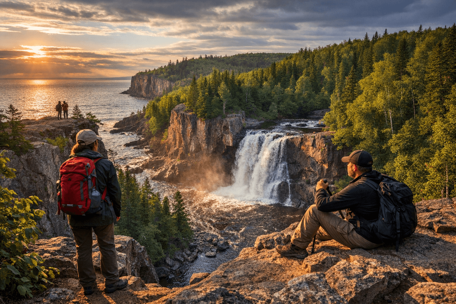
3. Shovel Point: short lakeside hike and wave watching
From the visitor center, hike along the lakeside cliffs to the end of Shovel Point for soaring views over Lake Superior and rock climbers in action; Hellostranger describes Shovel Point as “a 1-2 mile hike beginning at the Tettegouche Visitor Center.” The route features dramatic cliff views all around and is a popular spot for wave watching in stormy months, with Hellostranger noting it is “a very popular spot for wave watching in the stormy months of November and December.” The trail is accessible to many visitors but remains exposed—stay on the designated path and supervise children around cliff edges.
4. Cascade Trail and the Cascades Waterfall
Follow the Cascade Trail along the Baptism River to the Cascades Waterfall for close views of rushing water framed by stately, giant pines; MNDNR directs visitors to “Follow the Cascade Trail along the Baptism River to the Cascades Waterfall. Experience views of rushing waters and stately, giant pines.” The river has carved high cliffs here, so the hike offers both riverine scenery and rugged topography; plan footwear and time accordingly.
5. Baptism River, the gravel beach and geology
“Step into the park and view the rushing waters of the Baptism River as they cleave a 1.1 billion year-old, rugged rhyolite ridge that rises over the Lake Superior shoreline,” the MNDNR map-and-guide declares, highlighting the park’s deep geologic history. A short walk of a few city blocks from the visitor center leads to a gravel beach where “the Baptism River meets Lake Superior,” a calm spot for reflection or rock-skipping; this confluence is also one of the accessible, lower-elevation destinations noted in the park’s “ONLY HAVE AN HOUR?” guidance.
6. Safety, gear and emergency planning
Official guidance warns: “Wear good hiking shoes (not flip flops),” “Hiking trails cross rugged and difficult terrain, use caution,” “There are cliffs. Keep small children close and be aware of surroundings,” and “Please stay on trails.” MNDNR emphasizes that “Swimming at the park can be dangerous. River and lake conditions are unpredictable,” and repeats the emergency instruction: “In an emergency call 911.” Dogsanddetours notes that “Cell service is not guaranteed in the area; neither is a quick rescue in the event of an emergency,” underscoring the need to plan for self-sufficiency, tell someone your itinerary, and carry basic first-aid supplies.
7. Camping, reservations and seasonal demand
Campsites “fill quickly from June-September, reserve early,” MNDNR states; Dogsanddetours echoes campground logistics and recommends you “Check in with a park ranger if you’re camping in the park” and to “Purchase firewood for a campfire at your campsite.” The combined guidance is practical and simple: reserve ahead for summer stays, register with staff on arrival, and use park-sold firewood to reduce invasive-wood pest risks.
8. Leave No Trace and Indigenous cultural context
Hellostranger reminds visitors: “When recreating on the North Shore of Lake Superior and in Tettegouche State Park keep in mind that you are recreating on land with historical and cultural significance to the Anishinabee Nation. Treat every trail as a potential historical or cultural site and avoid digging, damaging trees, removing rocks, venturing off trail, and/or disturbing the natural environment.” Dogsanddetours likewise states that “The North Shore of Minnesota is the ancestral homeland of the Anshinaabe Indigenous People, and we are all guests on their land.” Both sources list LNT priorities: stay on official trails, clean your boots to avoid transporting invasive species, pack out all waste including toilet paper and food peels, and plan carefully for safety. The sources spell the Indigenous name differently—“Anishinabee Nation” and “Anshinaabe Indigenous People”—so validation with tribal authorities is recommended when reporting or interpreting cultural details.
9. Pronunciation and local cues
How do you say the park name? Dogsanddetours is emphatic: “It is pronounced ‘Tette-a-goosh’!” and elsewhere renders it “pronounced tet-uh-goosh.” Using the local pronunciation helps avoid signaling that you’re unfamiliar with the North Shore and respects local familiarity.
10. Practical public-health and equity considerations for Lake County visitors
A Minnesota State Parks permit is required and “can be purchased at the visitors center,” which is straightforward if you arrive during office hours; however, the combination of required passes, limited office hours, and inconsistent cell service can create barriers for people who arrive late, lack transportation, or face language or financial barriers. Cell-service gaps noted by Dogsanddetours (“Cell service is not guaranteed in the area; neither is a quick rescue in the event of an emergency.”) also have public-health implications for timely emergency care on rugged trails and cliff overlooks. Community planning and park signage that clearly explains permit rules, low-cost access options, and emergency procedures support both safety and equity across Lake County.
11. Contact, official notice and referral
The Minnesota Department of Natural Resources map-and-guide header records the park’s official contact: “© 2019, Minnesota Department of Natural Resources − MAP AND GUIDE: TETTEGOUCHE STATE PARK 5702 HIGHWAY 61 EAST SILVER BAY, MN 55614 LAKE COUNTY 218-353-8800 TETTEGOUCHE.STATEPARK@STATE.MN.US.” For current road and trail conditions, hours, or to begin reservations, contact the park by phone or email and pick up a map at the visitor center.
12. Known gaps and reconciliation notes to resolve before publication
The supplied sources contain no operational details for Split Rock Lighthouse State Park despite its appearance in the headline; no campsite counts or fees; limited trail distances beyond Shovel Point’s 1–2 miles; and no visitor statistics or comprehensive rules (leash laws, drone restrictions). Sources use different spellings for local Indigenous names and differ slightly on emphasis; the acreage figure (9,300 acres) appears in Dogsanddetours while the MNDNR excerpt in this packet emphasizes geology and did not repeat acreage. Journalists should confirm campground inventories, permit fee details, Split Rock specifics, and preferred tribal name spellings with official park staff and tribal authorities before final publication.
Conclusion Tettegouche’s cliffs, river-carved waterfalls and short, spectacular hikes make it an essential stop on the Lake County North Shore, but safety, seasonality, cultural respect and access matter as much as scenery. Plan ahead—buy your permit at the visitor center during office hours, reserve campsites early for June–September, follow Leave No Trace and Indigenous-land guidance, and treat cliff edges and stormy waves with respect—so this landscape remains a shared resource for Lake County residents, visitors and the Anishinaabe people whose homelands it is.
Sources:
Know something we missed? Have a correction or additional information?
Submit a Tip