Tornadoes and flash floods batter the Midwest and South
At least 20 tornadoes hit the Chicago-area forecast region as flash floods trapped people in the South, exposing how fast one severe-weather outbreak can overwhelm responders.
Tornadoes ripped through northern Illinois and northwest Indiana while flash floods trapped residents in homes and vehicles farther south, forcing emergency crews to split attention between wind damage and high water across a wide swath of the country. In the Midwest, downed trees and shredded buildings marked a storm line that produced multiple strong tornadoes; in the South, water rescues became the immediate priority as roads and neighborhoods filled with rising water.
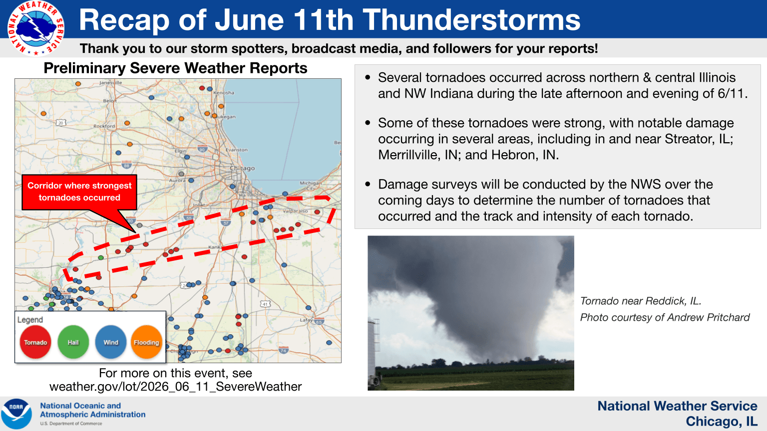
The National Weather Service said the June 11 outbreak in its Chicago-area responsibility produced at least 20 confirmed tornadoes, including preliminary EF-3 ratings near Long Point to Streator, Illinois, and in Wellington and Prairie Green Township, Illinois. The same review said destructive straight-line winds hit parts of the Chicago metro, while heavy rain from training thunderstorms caused flooding in far northern Illinois. In central Illinois, the National Weather Service said two consecutive days of severe storms on June 10 and 11 brought widespread damaging winds, tornadoes and isolated large hail, with preliminary surveys confirming 12 tornadoes, including an EF-3 near Washburn, Illinois.

The scale of the event underscored how a single weather pattern can layer hazards on top of one another. Forecasters had warned days earlier that a multi-day severe threat across the central U.S. could bring large hail, damaging wind gusts, flash flooding and tornadoes, and that is exactly how the system unfolded across the Midwest and beyond. With one region dealing with structural damage and another confronting dangerous water rescues, the strain on local response teams grew quickly.
The storms also highlighted the importance of NOAA’s reporting and tracking systems, which feed emergency managers with real-time information on tornadoes, heavy rain and flash flooding. NOAA’s storm database records U.S. events back to January 1950, while its rainfall and flash-flood reporting system captures flash-flood, flood and heavy-rain reports, along with stream gauge and rainfall exceedance data. Those records help officials map where the damage is spreading and where the next round of alerts may be needed as the cleanup begins and more rounds of severe weather remain possible.
This article was produced by Prism’s automated news system from verified source data, official records, and press releases, then run through automated quality and moderation checks before publishing. The system is built and supervised by the people who set the standards it runs under. Read our full AI policy.
Know something we missed? Have a correction or additional information?
Submit a Tip