Interagency Crews Ignite 288 Acres Near Bayfield in Spring Prescribed Burns
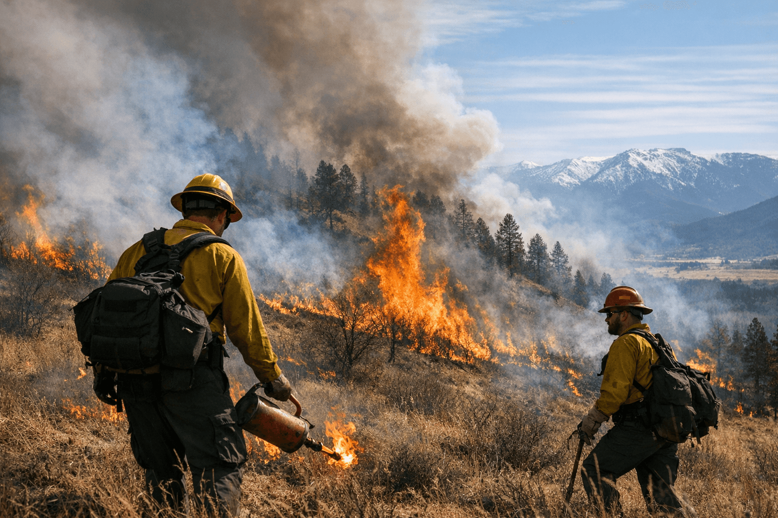
Smoke drifted north of U.S. 160 near Bayfield on March 18 as crews ignited 288 acres at Rabbit Mountain, part of a 2,285-acre BLM spring fuels program across three counties.
A controlled burn sent up a plume of smoke north of U.S. Highway 160, targeting the Rabbit Mountain area south of County Road 502, about 5 miles northeast of Bayfield. The project began Tuesday with a 79-acre burn, the Interagency Fire Dispatch Center reported in a Facebook post. An additional 209 acres were planned for Wednesday, bringing the total treatment at Rabbit Mountain to about 288 acres.
The Southwest Colorado Fire and Aviation Management Unit performed the controlled burn near Rabbit Mountain, located between Durango and Bayfield on the north side of U.S. Highway 160. The Interagency Fire Dispatch Center confirmed that no other fires, controlled or wild, were active in La Plata County during the operation.
The prescribed burn was one of several planned to treat 2,285 acres of land in Southwest Colorado managed by the Bureau of Land Management, according to a March 10 news release from the BLM Southwest District. The U.S. Wildland Fire Service plans to treat areas in La Plata, Dolores and San Miguel counties through May.
The San Miguel County operation will target the Dawson area, located south of Disappointment Valley, about 17 miles northeast of Dove Creek, and also at Summit Point, about 6 miles southwest of Slick Rock. Summit Point sits roughly 2.5 miles east of the Utah border. Operations in the Dawson area will also extend into Dolores County, covering the same stretch south of Disappointment Valley near Dove Creek.
Smoke may be visible during active burning, especially in the afternoon, and could linger in low-lying areas during cooler evenings. Nearby communities may notice residual smoke as piles smolder post-ignition. Fire personnel will be on-site throughout operations to ensure public safety.
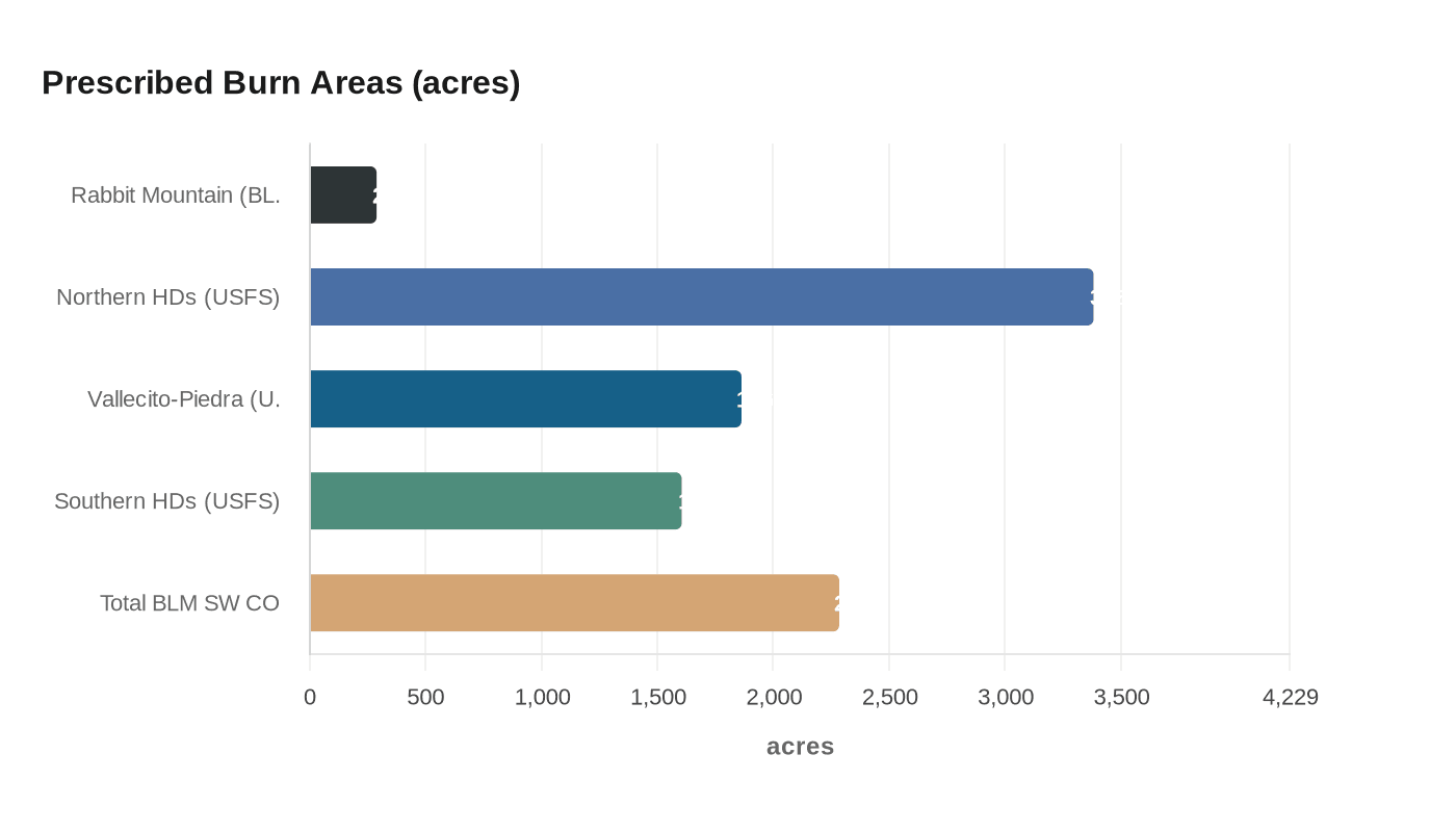
On the San Juan National Forest side of the ledger, a separate set of projects planned by the USDA's Columbine Ranger District targets substantially larger footprints in the same general zone. The Northern HDs Prescribed Fire covers multiple units totaling 3,383 acres in the Saul's Creek drainage east of Bayfield and south of Highway 160. The Vallecito-Piedra Prescribed Fire adds 1,863 acres in the Beaver Meadows area north of Highway 160 northeast of Bayfield. A third project, the Southern HDs Prescribed Fire, covers 1,605 acres in the Fosset Gulch area west of Chimney Rock National Monument. These are distinct USDA Forest Service projects on National Forest lands, planned separately from the BLM's spring 2026 broadcast burn program.
For those planning time outdoors in the corridor, the USDA San Juan National Forest has noted that daytime smoke from area burns typically travels to the north and northeast, while nighttime smoke drops downslope into the Piedra and Pine River drainages. Smoke tends to run heaviest in the mornings following ignition days, clearing by midday. Communities from Arboles to Pagosa Springs, and drivers along the U.S. Highway 160 and 151 corridors near those towns, can expect periodic visibility impacts through the active burn season.
Tyler Corbin, Fuels Specialist with the U.S. Wildland Fire Service, summarized the operational philosophy simply: "We take advantage of the right weather windows to put good fire on the ground." Burning operations are always contingent on personnel availability, fuel conditions, weather, and approval from the Colorado Department of Public Health and Environment.
Project pages for Rabbit Mountain, Dawson, Summit Point, and West Rim are maintained on InciWeb for daily operational updates and unit maps. For questions about the San Juan National Forest burns, District Assistant Fire Management Officer Noah Daniels can be reached at noah.daniels@usda.gov. For general information on the BLM-managed operations, contact John Wroblewski, USWFS Fire Mitigation Education Specialist, at (970) 240-5335.
This article was produced by Prism’s automated news system from verified source data, official records, and press releases, then run through automated quality and moderation checks before publishing. The system is built and supervised by the people who set the standards it runs under. Read our full AI policy.
Did this article answer your question?

