Lake Powell recedes, Glen Canyon’s desert riparian habitat returns
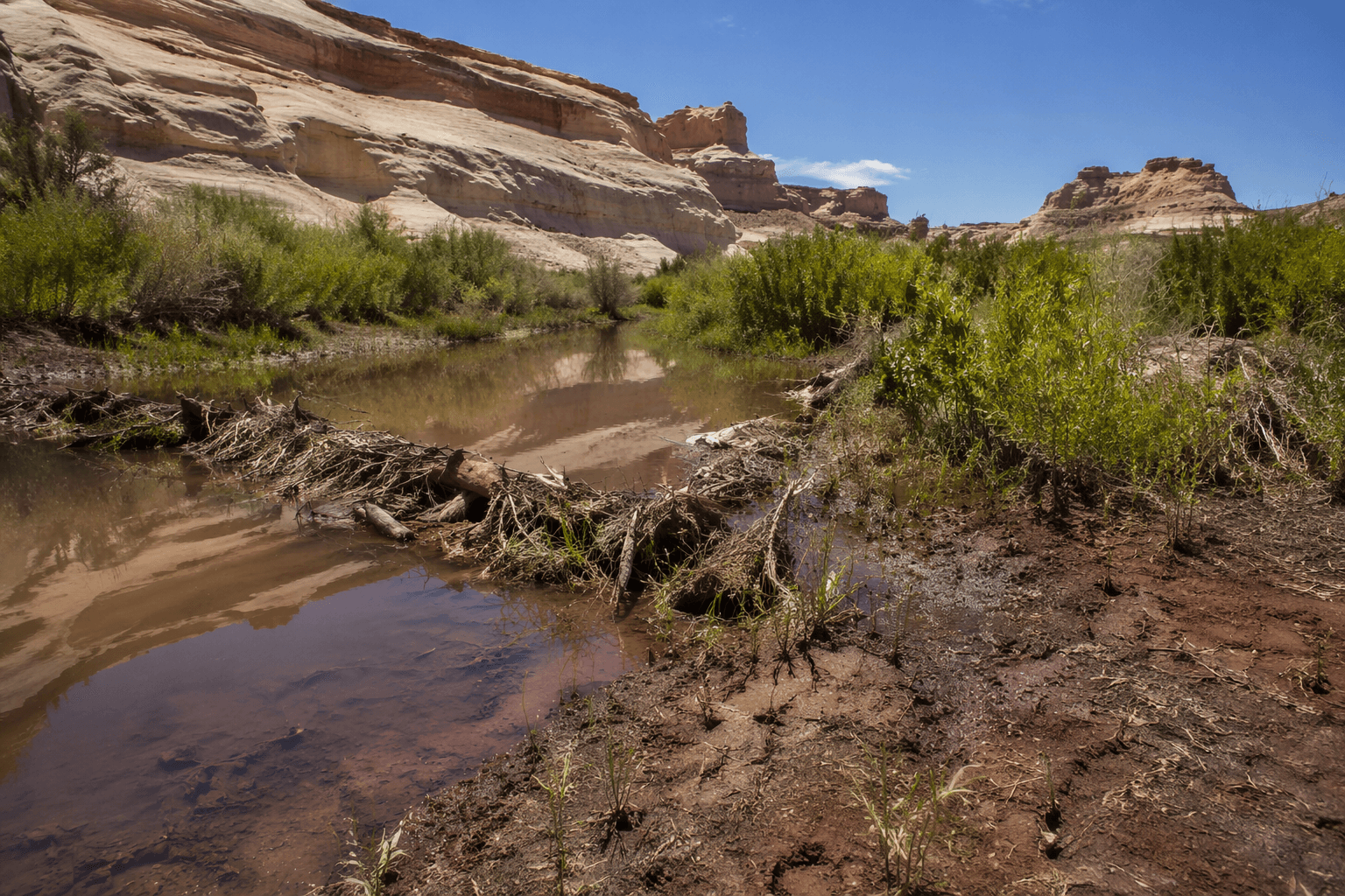
As Lake Powell drops, Davis Gulch is filling back in with willows, side streams, beaver dams, and toads. The view is changing fast, and so are access and safety conditions.

The first thing you notice in Davis Gulch is that the canyon floor is acting alive again. Toads are back, small beaver dams are catching water, side streams are running, and willows are thickening over mud and sand that sat under Lake Powell only a few years ago. That is the surprise Glen Canyon is serving up now: not just exposed rock, but a returning desert riparian corridor.
Davis Gulch is not just a shoreline anymore
Davis Gulch is one of dozens of side canyons that have come back into view as the reservoir drops, and it is showing how fast the place is changing. Native vegetation is colonizing ground that had been underwater, which means the old image of Glen Canyon as a drowned landscape no longer tells the whole story. The canyon floor is not a dead basin waiting to dry out, it is a living patchwork of mud, sand, water, and new growth.
For people who have only known Powell as a big-water playground, that shift matters. A walk into these reappearing canyons is less about staring at a bathtub ring and more about watching a desert riparian system rebuild itself in real time. The fact that toads, beaver activity, and flowing side channels are showing up together is the clearest sign that the landscape is not simply emptying out, it is reorganizing.
How Lake Powell got here
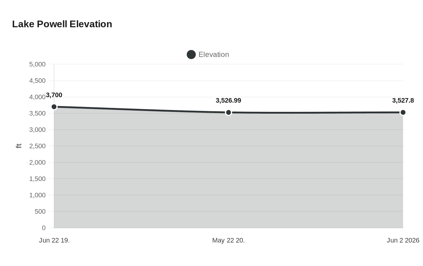
The long arc is hard to miss once you put the dates side by side. Glen Canyon Dam began filling Lake Powell on March 13, 1963, and the reservoir did not reach full pool until June 22, 1980, at 3,700 feet above sea level. What looked permanent for a generation is now clearly reversible, at least along the edges and in the side canyons.
Sediment has also been quietly eating away at the lake’s storage. The U.S. Geological Survey found that Lake Powell’s full-pool storage capacity declined by 6.79 percent, or 1.833 million acre-feet, from 1963 to 2018. That works out to an average annual loss of about 33,270 acre-feet per year, which is one reason the reservoir behaves less like a fixed basin and more like a changing system.
The current numbers underline the scale of the drop. Bureau of Reclamation status data updated May 22, 2026 put Lake Powell at an end-of-April elevation of 3,526.99 feet, with 5.62 million acre-feet of storage, or 24 percent of live capacity. U.S. Geological Survey real-time data put the lake at about 3,527.8 feet on June 2, 2026. That is a very long way from full pool, and every foot matters when you are trying to launch a boat or read a shoreline.
What it means on the ground for hikers, boaters, and road-trippers
The National Park Service has been blunt about the new reality: declining water levels from climate change and 20 years of drought have reshaped Lake Powell’s shoreline since 2001. Visitors now have to expect exposed shorelines, submerged obstacles, narrower or shifting channels, and changing availability at ramps and facilities. That is not abstract cautionary language, it is the difference between a smooth day and a bad one.
For hikers, the returning canyon floors are the big draw, but they are also delicate. Fresh mud, sand, and young willow growth can be easy to damage, and the ground you think of as “shoreline” may actually be a recovering habitat with side streams and saturated soils underneath. Davis Gulch is exactly the kind of place where the landscape is changing faster than most visitors expect.
For boaters, the challenge is different. A reservoir that once felt familiar can change shape season to season, and sometimes faster than that. Narrower channels, hidden obstacles, and shifting waterlines mean the route you used last trip may not match the one in front of you now.
Road-trippers get the visual payoff without needing a launch ramp, and that may be the easiest way to appreciate the transformation. Glen Canyon National Recreation Area covers more than 1.25 million acres, so this is not a minor corner of the map. Around Page, Arizona, the reservoir’s retreat is turning familiar red rock-and-water views into something stranger and, in many spots, more interesting.
Why scientists and advocates are paying close attention
The comeback in Davis Gulch has also sharpened the debate over what Glen Canyon really is. Zanna Stutz and David Wegner of Glen Canyon Institute see the rebound as proof that the canyon floor is ecologically active, not some wasteland waiting to be written off. That matters because the landscape itself is now providing evidence that riparian habitat can return when the waterline moves back.
Reclamation still describes Lake Powell as a “bank account” of water for the Colorado River system, and that phrase captures the tension better than any brochure ever could. The lake is not just scenery, it is storage, drought insurance, and part of the hydropower system. Glen Canyon Powerplant has eight generators and 1,320 megawatts of capacity, so every drop in the reservoir carries meaning far beyond the view from the shore.
The practical takeaway for anyone heading into the Four Corners is simple: Lake Powell is no longer a static destination. It is a moving edge where access, ecology, and safety keep changing, and Davis Gulch is the clearest sign yet that the canyon country under the water is not gone. It is coming back, one willow, one side stream, and one beaver dam at a time.
This article was produced by Prism’s automated news system from verified source data, official records, and press releases, then run through automated quality and moderation checks before publishing. The system is built and supervised by the people who set the standards it runs under. Read our full AI policy.
Know something we missed? Have a correction or additional information?
Submit a Tip