Moab Council weighs OHV speed limits, trail signs, drought campaign
Moab is tightening the screws on trip logistics, with OHV rules, trail signs, and drought prep all shifting at once. Riders, hikers, and outfitters will feel it first at trailheads and campgrounds.
Moab’s spring reset is about access, not politics
Moab is heading into its busiest stretch with three things changing at once: OHV speed rules, trail signage, and drought prep. If you are rolling into town with a truck, a UTV, a bike rack, or a campground reservation, those updates matter more than the council agenda language behind them.
The clearest signal is that the city and Grand County are no longer singing from the same sheet on OHV speed limits. Grand County commissioners voted 4-3 on April 7, 2026, to repeal a 2020 ordinance that had forced off-highway vehicles to stay below posted speed limits on county roads. That means street-legal OHVs now follow the same posted limits as other vehicles on county roads, after county leaders said the separate signs were confusing and could make it seem like illegal OHVs were allowed on public streets. For anyone driving out to trailheads on Spanish Valley Drive, Mil Creek Drive, or other high-traffic approach roads, that is a meaningful shift in how the rules read from the windshield.
Moab City is still treating OHV noise as a real neighborhood issue, and that is the part travelers notice fastest. The city says street-legal OHVs are allowed to drive through town to reach backcountry trailheads, but its own guidance calls the noise a significant concern and says the valley geography amplifies sound in nearby neighborhoods. City rules also still require all street-legal OHVs to obey a 15 mph limit on posted city streets, and vehicles over 92 dBA, plus certain vehicles over 85 dBA at night, may not be driven on city streets. That is not just fine print for the rule book, it is the difference between a clean arrival and a bad welcome from residents trying to sleep after dark.
What the council meeting means on the ground
At its April 28 meeting, Moab City Council looked at speed limits on certain routes while also getting department updates tied to wayfinding and water conservation. The practical takeaway is simple: the city is trying to keep recreation moving without turning every approach road and trailhead into a free-for-all. Moab Sun News reported that staff also said the old OHV signs were never legally enforceable under state law and planned to remove them, which matters because the visual clutter alone can shape how people drive before they ever read the fine print.
That change should help cut down on the kind of confusion that hits first-time visitors hard. Moab is not a one-trail town. It is a maze of public-land access, campground rules, permit systems, and route-specific closures that all stack up fast once the Easter Jeep crowd, spring break families, and shoulder-season riders arrive. Clearer road and trail signs will not solve every problem, but they can prevent the classic Moab mistake: assuming the route to the trailhead is as simple as following the dust.
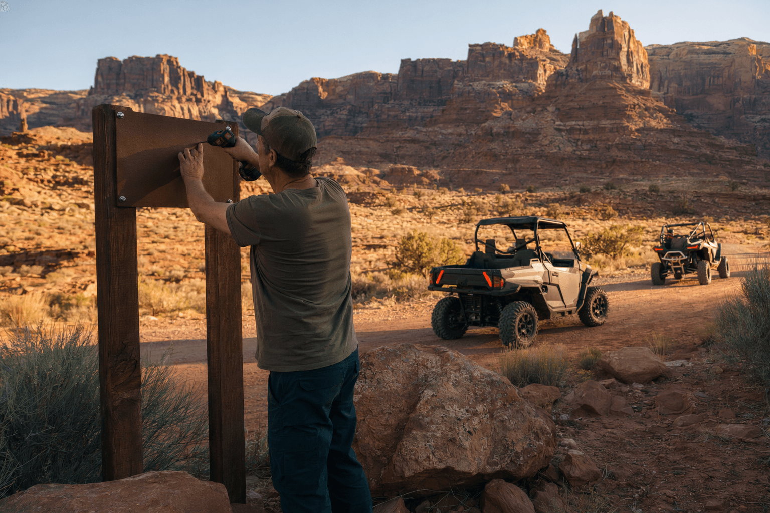
Trail signs are a trip-planning issue, not just a civic one
The new trail sign system matters because Moab visitors are constantly moving between town streets, staging areas, dispersed camping, BLM campgrounds, and reservation-based park campgrounds. If the signs are cleaner and consistent, you waste less time hunting for the correct turnoff and less time re-routing a trailer around a jammed lot. That is especially useful around crowded launch points where one bad turn can throw off a whole day, whether you are heading toward Sand Flats Recreation Area, Kane Creek, or a slickrock route with a late-afternoon start.
The bigger context is scale. The Bureau of Land Management says the Moab Field Office manages about 1.8 million acres of public land and administers nearly 500 special recreation permits each year. That is a lot of moving parts for one destination, and it explains why wayfinding is not cosmetic. In a place this busy, a sign that makes sense can save you fuel, time, and a headache.
If you are planning a Moab run now, the smartest habit is still the old one: check the route, then check it again when you arrive. The BLM’s Moab Visitor Guide says the Moab Information Center is a regional interagency visitor center with trip-planning resources, guidebooks, maps, and free Wi-Fi, which makes it the first stop worth building into a busy itinerary. It is the kind of place that saves a day when your campground reality does not match the reservation you thought you had.
Water is the sleeper issue for spring travelers
The city’s drought campaign may sound less dramatic than OHV enforcement, but it can affect your trip just as quickly. Moab officials are moving ahead of potential drought restrictions, which is the right time to pay attention because spring and early summer in red-rock country can turn dry fast. If restrictions tighten, the places that feel it first are campgrounds, lodging operations, and anyone trying to stage a multi-day trip without carrying enough water from the start.
Moab’s own public materials already remind visitors that water access is not universal. The BLM guide says drinking water at Lion’s Park, north of Moab, is seasonal and available in spring through fall. That is the kind of detail that seems minor until you are counting gallons before a route day or figuring out whether a campground has the basics you expected. The same guide also notes that campground fees vary, including $20 per night at some campgrounds and $25 per night at Horsethief Campground, which is another reason to confirm the small stuff before you leave home.
For outfitters, these details translate into real prep. Bring extra water, expect variable campground amenities, and assume that the most useful information will come from a visitor center or field office, not from a vague online map. For hikers and riders, it means packing with the season, not the forecast. In Moab, the weather is only part of the equation; the water system and campground setup matter too.
What to do differently on your next Moab trip
- Build in time at the Moab Information Center if you are trying to sort camping, route access, or permit questions in one stop.
- Keep street-legal OHVs at 15 mph on posted city streets, and do not assume county rules match city rules.
- Watch noise levels, especially at night, because Moab explicitly enforces decibel limits on city streets.
- Treat water like a core trip resource, not an afterthought, especially if you are headed to a campground with seasonal services.
- Expect the sign system to keep changing as the city clears out old markers and replaces them with something easier to read.
The bigger picture is that Moab is still wide open, but it is getting more intentional about how visitors move through it. That should help the people who plan ahead and punish the ones who assume the desert will sort it out for them.
This article was produced by Prism’s automated news system from verified source data, official records, and press releases, then run through automated quality and moderation checks before publishing. The system is built and supervised by the people who set the standards it runs under. Read our full AI policy.
Did this article answer your question?


