Hiking, Boating and Camping Essentials for Adams County Visitors and Residents
A one-stop guide to hiking, boating and camping in Adams County that highlights the Edge of Appalachia trails, flags missing boat-ramp and campsite details, and lists follow‑ups for safe, equitable access.

Quick overview This guide consolidates verified Adams County, Ohio resources for hiking, boating and camping: the Edge of Appalachia Preserve System and its trails and Eulett Center; the Hiker’s Guide and maps from The Nature Conservancy; and the guide’s original scope, Adams Lake State Park, public boat ramps on the Ohio River and Ohio Brush Creek, and locally run campgrounds and marinas, while flagging where critical location and access details remain unavailable and must be confirmed before travel.
Core facts and purpose The original brief defined the scope: “state-managed preserves, the small but distinctive Adams Lake State Park, public boat ramps on the Ohio River and Ohio Brush Creek, and locally run campgrounds and marinas.” The Nature Conservancy, working with local partners and Leadership Adams, produced a Hiker’s Guide to Adams County, Ohio described as “a detailed brochure of nature trails, maps and interpretive information to make visiting Adams County easy and enjoyable. Download the map.” This article uses those verified Ohio items as the foundation, preserves all unique source material, and clearly labels unrelated Adams County (Wisconsin) campground details included in the research.
1. Hiking: Edge of Appalachia Preserve System, trail names and the Eulett Center
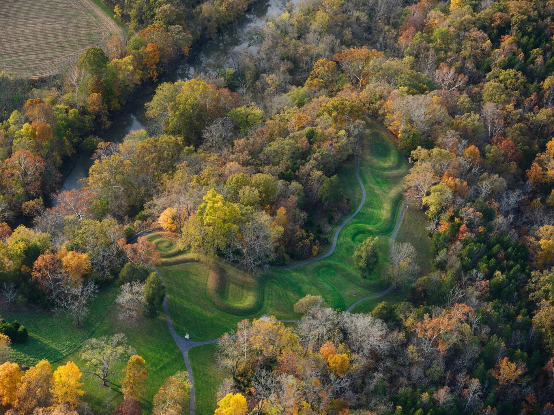
The Edge of Appalachia Preserve System is managed through partnerships including The Nature Conservancy and the Cincinnati Museum Center; the preserve system totals about “21,000 acres.” Named trails and preserves listed in the TNC materials include the E. Lucy Braun Lynx Prairie Preserve Trail, The Charles A. Eulett Wilderness Preserve Trail, Christian and Emma Goetz Buzzardroost Rock Preserve Trail, Joan Jones Portman Trail and Dr. George Rieveschl Jr. Creek’s Bend Overlook, and John and Marion Becker Cedar Falls Preserve & Helen C. Black Trail. The Eulett Center “is a hub for that partnership. It sits tucked into a hillside overlooking the preserve and serves as staff offices, meeting space and research lab,” making it the logical first stop for orientation, programs and research inquiries before heading onto the preserves. The Nature Conservancy’s Hiker’s Guide and the Edge of Appalachia and Buckeye Trail Map are explicitly listed as downloadable resources for trail maps and interpretive information, obtain the Hiker’s Guide PDF before you go for trailheads, difficulty ratings and parking instructions.
2. Boating: public boat ramps on the Ohio River and Ohio Brush Creek (what we know and what’s missing)
The original brief explicitly calls for coverage of “public boat ramps on the Ohio River and Ohio Brush Creek,” but the supplied materials do not include names, addresses, GPS coordinates, ramp conditions, parking capacity or fee information. For safety, trip planning and equitable access (including trailer parking and ADA launch availability), confirm ramp details with the Adams County Travel & Visitors Bureau, the county parks office and the Ohio Department of Natural Resources before launching. This information gap matters for emergency response and public health: knowing ramp locations, parking rules and seasonal capacity helps prevent overcrowding, unsafe launches, and delayed rescue responses on the Ohio River and its tributaries.
3. Camping: Adams Lake State Park, local campgrounds and data gaps
The brief names “the small but distinctive Adams Lake State Park” as a core camping resource, but no operational details (address, acreage, camping availability, fees, facilities or hours) were provided in the supplied sources. Locally run campgrounds and marinas in Adams County, Ohio were listed as a category to include, but no names or contacts appear in the verified Ohio material. Because access to nearby camping and waterfront overnight options affects visitor safety, local revenue and equitable access to nature, obtain official Adams Lake State Park details from the Ohio Department of Natural Resources and a full directory of private campgrounds and marinas from the Adams County Travel & Visitors Bureau before publishing scheduling or reservation guidance.
Maps, guides and interpretive materials The Nature Conservancy materials name two practical downloadables: the Hiker’s Guide to Adams County, Ohio (“a detailed brochure of nature trails, maps and interpretive information”) and the Edge of Appalachia and Buckeye Trail Map. These are the primary planning tools verified in the research and should be linked or attached for readers once permissions are secured. For wayfinding and public-safety planning, request exact map download URLs and licensing from The Nature Conservancy and confirm whether print copies are available at the Eulett Center.
Community, local businesses and visitor services “The Nature Conservancy and the Edge of Appalachia Preserve System are part of an active community of local businesses and organizations working to promote the exciting destinations and things to do in Adams County,” and visitors are specifically encouraged to “Spend the day on the trails but make sure to explore the rest of what Adams County has to offer at the Adams County Travel & Visitors Bureau. Follow backroads to find quilt barns, Amish baked goods, historic sites and much more.” Use the Travel & Visitors Bureau as the primary local contact for lodging, events and non-hiking attractions; they should also supply up-to-date lists of campgrounds, marinas and boat ramp locations.

- “New Campground as of 2023 Season! "Nature enjoyed better" ... RVing with a private crystal clear lake...” (promotional heading)
- Evergreen Hollows, 1411 Evergreen Ave Easton, WI 53936, (608)-577-2847. “Evergreen Hollows offers several 50-amp sites with water, sewer, and electricity. The pool is expected to open by mid-August. The resort also features a one-bedroom cabin and a two-bedroom cabin with a loft. Additionally, there will be a game room complete with a pool table, air hockey, and foosball.”
- Petenwell County Park, 2004 Bighorn Dr Arkdale, WI 54613, (608)-564-7513. “Petenwell County Park, the 2nd largest county park in Wisconsin... This 160 acre park ... includes a game room, designated swimming area, boat launch... Harbor of Refuge with slips for transient use, heated shower/restroom facility... Firewood and ice is available.”
- Pineland Camping Park, 916 State Hwy 13 Arkdale, WI 54613, (608)-564-7818.
- Castle Rock County Park, 2397 County Road Z Friendship, WI 53934, (608) 339-7713.
Note: Adams County, Wisconsin campground listings (separate, do not conflate)
The research packet included detailed campground listings for Adams County, Wisconsin; these are not located in Adams County, Ohio and must be treated separately. Verbatim items preserved for editorial reference include:
These Wisconsin entries must not be used as factual claims about Adams County, Ohio.
Public health, equity and safety considerations Access to clear, current information about trailheads, boat ramps and campgrounds is a public-health priority: it affects emergency response times, overcrowding risk, water safety and who can reach outdoor spaces. Gaps in accessible information, especially about ADA access, parking capacity and restroom/shower facilities, disproportionately burden residents without private transport and visitors who rely on public information to plan safe outings. Prioritize confirming ramp and campsite accessibility, fees and parking rules so that low-income families, elder visitors and people with disabilities can make equitable, safe choices.
- Obtain the Hiker’s Guide to Adams County, Ohio PDF and the Edge of Appalachia/Buckeye Trail Map download link and licensing from The Nature Conservancy.
- Ask The Nature Conservancy for trailhead locations, trail lengths and difficulty ratings for each named trail, and Eulett Center contact, hours and photo permission.
- Contact the Adams County Travel & Visitors Bureau for a verified list of public boat ramps on the Ohio River and Ohio Brush Creek (names, addresses, GPS coordinates), and for a directory of local campgrounds and marinas in Adams County, Ohio.
- Confirm Adams Lake State Park details (address, acreage, camping, fees, hours) with the Ohio Department of Natural Resources.
- Verify ADA access, fees, trailer parking capacity and seasonal closures for ramp locations with county or state park officials.
Missing information and recommended follow-up reporting (high priority)
- “The Eulett Center is a hub for that partnership. It sits tucked into a hillside overlooking the preserve and serves as staff offices, meeting space and research lab.”
- “The Nature Conservancy in partnership with many other organizations, as part of Leadership Adams, created a Hiker's Guide to Adams County, Ohio. The guide is a detailed brochure of nature trails, maps and interpretive information to make visiting Adams County easy and enjoyable. Download the map.”
- “The Nature Conservancy and the Edge of Appalachia Preserve System are part of an active community of local businesses and organizations working to promote the exciting destinations and things to do in Adams County. Spend the day on the trails but make sure to explore the rest of what Adams County has to offer at the Adams County Travel & Visitors Bureau. Follow backroads to find quilt barns, Amish baked goods, historic sites and much more. Here are a few other opportunities to enjoy the area.”
- (Wisconsin promotional quote) “New Campground as of 2023 Season! "Nature enjoyed better" They are proud to offer RVing with a private crystal clear lake, hiking trails, parks, playgrounds, swim pond with toys, food/drink, and so much more... Come tour and pick your site now.”
Direct quotes preserved verbatim for use
Conclusion and next steps Use the Edge of Appalachia resources and the Hiker’s Guide as the foundation for safe, restorative outings in Adams County, Ohio; treat Adams Lake State Park, boat ramps and local campgrounds as high-priority follow-ups to verify before relying on them for travel plans. Confirming ramp locations, campsite contacts and accessibility details will protect public safety, support equitable access to nature, and help local businesses and emergency services manage visitor flows responsibly. The Nature Conservancy, the Cincinnati Museum Center, the Adams County Travel & Visitors Bureau and the Ohio Department of Natural Resources are the priority contacts to complete this guide for publication and community use.
This article was produced by Prism’s automated news system from verified source data, official records, and press releases, then run through automated quality and moderation checks before publishing. The system is built and supervised by the people who set the standards it runs under. Read our full AI policy.
Did this article answer your question?