Alamance County historical monuments page highlights Revolutionary War sites
Alamance County’s monument map is a ready-made Revolutionary War driving loop, from free Alamance Battleground tours to roadside markers in Burlington, Graham, and Mebane.

Why these monuments matter now
Alamance County’s historical monuments page is not just a list of plaques. It is a workable map of how the Revolutionary era still sits in plain sight across Burlington, Graham, Mebane, and southern rural communities, especially as local institutions lean into America 250 programming and renewed attention to North Carolina’s independence story. For residents who have never stopped at these places, the page answers a practical question: where can you still see the county’s early history without making a full museum day of it?
That matters in Alamance County because the county itself is relatively young, formed in 1849 from Orange County, with Graham named the county seat that same year. The monuments spread that history across the county instead of concentrating it in one downtown block, which means a weekend history loop can touch a battleground, a courthouse, a cemetery, and a landscaped memorial garden in a single outing.
Start with Alamance Battleground
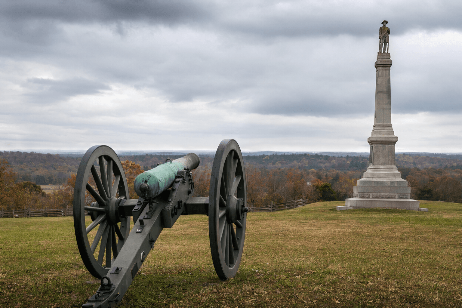
If you only stop at one place, make it Alamance Battleground State Historic Site on N.C. 62 in Burlington. The site covers a 40-acre rural tract and preserves the ground where, on May 16, 1771, Governor William Tryon’s militia fought the Regulators in a two-hour battle that helped shape the political unrest leading toward the Revolution. The state historic site includes a visitor center with maps and museum objects, a 1780 log house, battle-position markers, a cannon, and informational plaques, so it delivers the most context for the least amount of planning.
It is also the easiest stop to budget for: admission is free, the site is open Tuesday through Saturday from 9 a.m. to 5 p.m., and guided tours run at 11 a.m., 1 p.m., and 3 p.m. Guided tours and some special events carry fees, but the base visit does not, which makes it the best low-cost anchor for a family outing or school-age history lesson. The site’s 1880 granite monument and early highway marker also show that local memory of the battle has been public for generations, not just revived for recent tourism.
The battlefield also helps explain why Alamance still attracts attention during America 250 planning. The modern interpretive material does more than retell the fight between Regulators and Tryon’s militia; it places the battle inside a larger story of protest over taxes, fees, and political power in the colonial backcountry. For a weekend stop, that makes Alamance Battleground worth the drive because it is both the county’s signature Revolutionary-era site and the one with the clearest visitor infrastructure.
Add Pyle’s Defeat for a quick Burlington stop
Pyle’s Defeat is the kind of site you can fold into an errand run through Burlington. The monument sits near the intersection of Anthony Road and Old Trail, on the grounds of Splawn Belting, Inc., behind the main building, and it marks the February 25, 1781 ambush tied to Colonel John Pyle’s Loyalist force. The marble marker includes an image of Pyle on horseback, along with a bronze plaque and seal, and was installed on May 1, 1996 by The Alamance Foundation and the National Society, Sons of the American Revolution.
This site matters because it shows that the Revolutionary War in Alamance County was not just a clash between uniforms and flags. Pyle’s Defeat sits inside the southern backcountry civil war of the Revolution, where Henry “Light Horse Harry” Lee and Andrew Pickens were fighting Loyalist forces in a brutal and fast-moving campaign. If Alamance Battleground tells you how unrest exploded in 1771, Pyle’s Defeat shows how that unrest became full-scale wartime violence a decade later.
Make room for Lindley’s Mill in southern Alamance
Lindley’s Mill is the most important Revolutionary stop in southern Alamance, but it rewards a little more planning. The monument is in Southern Alamance near Jon Braxton Saw Mill and Lindley’s Mill, and the page notes that a battle tour is available upon request. The battle itself was fought on September 13, 1781, near Thomas Lindley’s mill on Cane Creek east of present-day Snow Camp, where Loyalist and Patriot forces collided in one of the state’s most intense backcountry fights.
What makes Lindley’s Mill worth the extra effort is its scale. NCpedia describes it as the largest engagement of North Carolina’s so-called Tory War, the civil conflict that followed Cornwallis’s invasion of the state, and notes that David Fanning’s Loyalist activity helped drive the fight. For a local reader, the site is a reminder that Alamance County’s Revolutionary history was not confined to one battlefield or one political side; it was lived through a contested landscape of mills, creeks, farms, and family ties.
Don’t skip the county’s memorials and civic spaces
The monuments page is especially useful because it does not stop at battlefields. Outside the Graham Courthouse, a war memorial honors Alamance County soldiers lost in five wars, putting county service into the civic center of the seat that was established when Alamance was formed in 1849. In Burlington’s Pine Hill Cemetery, the Alamance County War Memorial is a granite tribute to the men and women of World War II, erected by Walter B. Ellis Post No. 63 of the American Legion.
Mebane’s Veteran’s Garden, at N. 2nd St., offers a different kind of stop: a landscaped memorial honoring living and deceased veterans of the Army, Navy, Air Force, Marines, and Coast Guard. These sites matter now because they connect the county’s older military history to later generations of service, giving the monuments page a civic dimension that goes beyond the Revolution alone. If you are building a self-guided loop, they also give you meaningful stops in three separate municipalities without requiring a museum admission or a long indoor visit.
A wider historical loop, not a single destination
The page also points to monuments at Lake Mackintosh Park, where decorative engraved memorials honor the battles of Clapp’s Mill, Lindley’s Mill, and Pyle’s Defeat, and where picnic spots make the stop easy to pair with a lake visit. That is what makes the county’s monument map so practical: it lets you turn history into a route instead of a lecture, with one stop in Burlington, another in Graham, and another in southern Alamance or Mebane as time allows. The Allen House at Alamance Battleground, built around 1780 and restored with original furnishings, adds the domestic side of the story and helps bridge battlefield memory with everyday colonial life.
Taken together, these sites show that Alamance County’s past is spread across roads, courthouses, cemeteries, and preserved homesteads, not locked into a single archive. For anyone who wants to understand the county beyond its modern storefronts and subdivisions, this is the clearest kind of local-history roadmap: free where it should be, easy to reach, and rooted in places where the Revolution, county formation, and civic memory all still overlap.
This article was produced by Prism’s automated news system from verified source data, official records, and press releases, then run through automated quality and moderation checks before publishing. The system is built and supervised by the people who set the standards it runs under. Read our full AI policy.
Did this article answer your question?