Coronado Trail Scenic Byway winds through Apache County mountain towns
The Coronado Trail packs 123 miles, 400 switchbacks, and mountain-town stops into one high-country drive through Apache County.
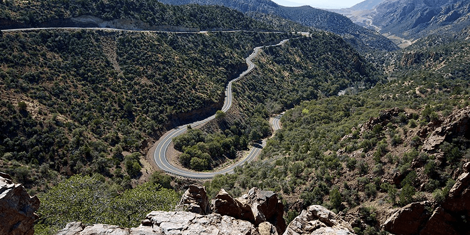
More than 400 switchbacks fold through the 123-mile Coronado Trail Scenic Byway. The drive runs about four to five hours without long stops, and it works best as a full-day or weekend route rather than a quick pass-through. There are no fees on the road itself, though some campgrounds along or near the byway do charge.
Start in the White Mountain towns
The northern end of the byway begins near Eagar and Springerville, where travelers can stock up, reset, and decide whether the day is for driving, hiking, or camping before the road starts to feel less like a highway and more like a thread through Apache County’s mountain communities. Springerville and nearby stops are a practical base for anyone planning to spend time in the Apache-Sitgreaves National Forests rather than just passing through.
From there, the byway moves toward Alpine and the White Mountain country, and the character of the drive changes quickly. The Apache-Sitgreaves National Forests cover 2 million acres and include more than 450 miles of rivers and streams, so the landscape is not one scene but a sequence of elevations, water, and timber.
Build the drive around forest access
The most useful way to experience the Coronado Trail is to pair the road with a trail guide or a forest detour. The Springerville Ranger District trail guide covers hiking, biking, cross-country skiing, and equestrian use, and the trail system there ranges from about 3,500 feet to nearly 11,000 feet at Escudilla Mountain. Most trailheads sit above 6,000 feet, which means even a short walk can feel very different from lower-elevation travel elsewhere in the county.
The forests rise from 3,500 feet on the Clifton Ranger District to over 11,000 feet in the Mount Baldy Wilderness, and the same route can move you across several ecosystems in a matter of hours. If you want a one-day version, keep the focus on the drive and one short stop. If you want a weekend, build in a campground night or a longer trail break.
Plan for weather, altitude, and road conditions
Mountain weather can change fast, and the ranger district warns that access roads to trailheads can be difficult in winter or after heavy rain. That makes timing important for anyone heading to the higher trailheads, especially if the plan includes dirt roads or a late-day return after weather turns.
Lower sections near Clifton and the surrounding country sit far below the high country around Alpine and Escudilla Mountain, so travelers can move from warmer, drier terrain into cooler forest in a single trip. Pack water, check road conditions, and avoid assuming that the weather at the trailhead matches the weather in town.
A route shaped by history, not just scenery
The Coronado Trail carries a long public memory. The road was dedicated on June 19 and 20, 1926, at Hannagan Meadow as the Coronado Trail and Clifton-to-Springerville Highway. Governor George W.P. Hunt attended the two-day celebration, which drew an estimated 5,000 people and included a barbecue with six fat steers and two bears. The road was named for Francisco Vázquez de Coronado, linking the byway to the older travel routes that crossed the Southwest long before the modern highway existed.
The road was once called Route 666 before it became U.S. 191. The byway’s official description says it follows former Native American footpaths that later became horse paths, wagon trails, and pioneer routes.
Where to stop on a practical day trip
For a day drive, the most useful stops are the ones that break up the road without turning the trip into a detour. Hannagan Meadow is one of the most recognizable pull-offs on the route, and it remains a natural place to pause and reset before or after the steeper mountain sections. Nelson Reservoir and Casa Malpais Indian Ruins and Archaeological Park in Springerville give the northern end of the byway more context, while the Morenci Open Pit Copper Mine anchors the southern end with a working-landscape contrast that is hard to miss.
These are not just viewpoints for outsiders. Apache County residents live, work, and move through the same roads, campgrounds, and trailheads that visitors use.
Make the most of a weekend in Apache County
A weekend gives the Coronado Trail its full shape. Drive one day from the Springerville and Eagar side into the high country, then use the second day for a trail, a campground, or a town stop in Alpine before heading back. The byway is officially designated as a National Scenic Byway.
This article was produced by Prism’s automated news system from verified source data, official records, and press releases, then run through automated quality and moderation checks before publishing. The system is built and supervised by the people who set the standards it runs under. Read our full AI policy.
Did this article answer your question?