Four Corners Monument draws visitors, vendors to Apache County borderland
Four Corners is more than a photo op: Apache County’s borderland stop funnels visitors into Navajo art, food, and a small tourism economy.

At Four Corners Monument, a quick photo stop becomes a small border economy. The only place in the United States where Arizona, Colorado, New Mexico and Utah meet now draws about 250,000 visitors a year, and those travelers do more than stand on a plaque: they buy Navajo art, stop for frybread and Navajo tacos, and keep a rural stretch of Apache County on the map. That spending matters because the monument sits in a remote corridor with limited services and no nearby accommodations, so the visit itself is built around planning, timing and a handful of on-site vendors.
A landmark that functions as a market
Apache County’s own visitor information puts Four Corners in the center of the county’s story for a reason. The county is unusually long, the Navajo Nation makes up a large share of both its population and land area, and the monument sits right where those realities meet the road. For travelers crossing the borderland, the stop is not just about geography. It is also one of the few places in the area where money changes hands directly with Native artisans instead of disappearing into a chain store somewhere else on the highway.
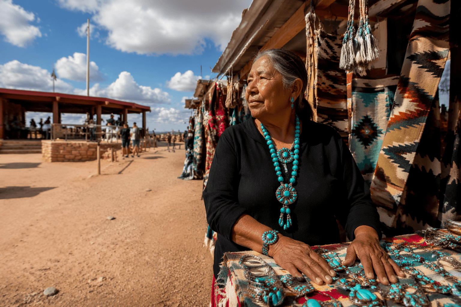
That is what separates Four Corners from a standard roadside attraction. Visitors do not just look at a marker and leave. They walk through a Navajo Nation park site, browse a vendor market, and buy authentic native art directly from the artisan. In a rural part of Apache County with limited services, that makes the monument a compact marketplace as much as a scenic landmark.
What is on site and when to go
The Navajo Nation Parks & Recreation schedule makes the site easy to plan around, even if the setting is intentionally sparse. The monument is open Monday through Sunday, and vendors operate from 8:00 a.m. to 5:00 p.m. It is closed on major holidays, including New Year’s Day, Thanksgiving Day, NN Family Day, the day after Thanksgiving, and Christmas Day.
A visit also comes with a few practical realities that matter in Apache County’s far north. There are no nearby accommodations, and services are limited, so travelers generally need to arrive with fuel, water and enough time to make the stop worthwhile. Visit Arizona notes that the visitor center is also part of the draw, with traditional dishes such as frybread and Navajo tacos available on site. For many road-trippers, that food stop is as much a part of the experience as the state-line photograph.
Useful basics for planning a stop:
- Open daily, Monday through Sunday
- Vendor hours: 8:00 a.m. to 5:00 p.m.
- Closed on major Navajo Nation holidays
- Limited services and no nearby accommodations
The history under the brass and granite
The monument visitors see today is not the first marker at the site. Navajo Nation Parks & Recreation says the original marker was a simple cement pad erected in 1912, later replaced by the granite-and-brass monument now associated with the site. NOAA’s National Geodetic Survey adds another layer to that history: the current monument complex was constructed in 1992, and its location is tied to an 1875 survey by Chandler Robbins.
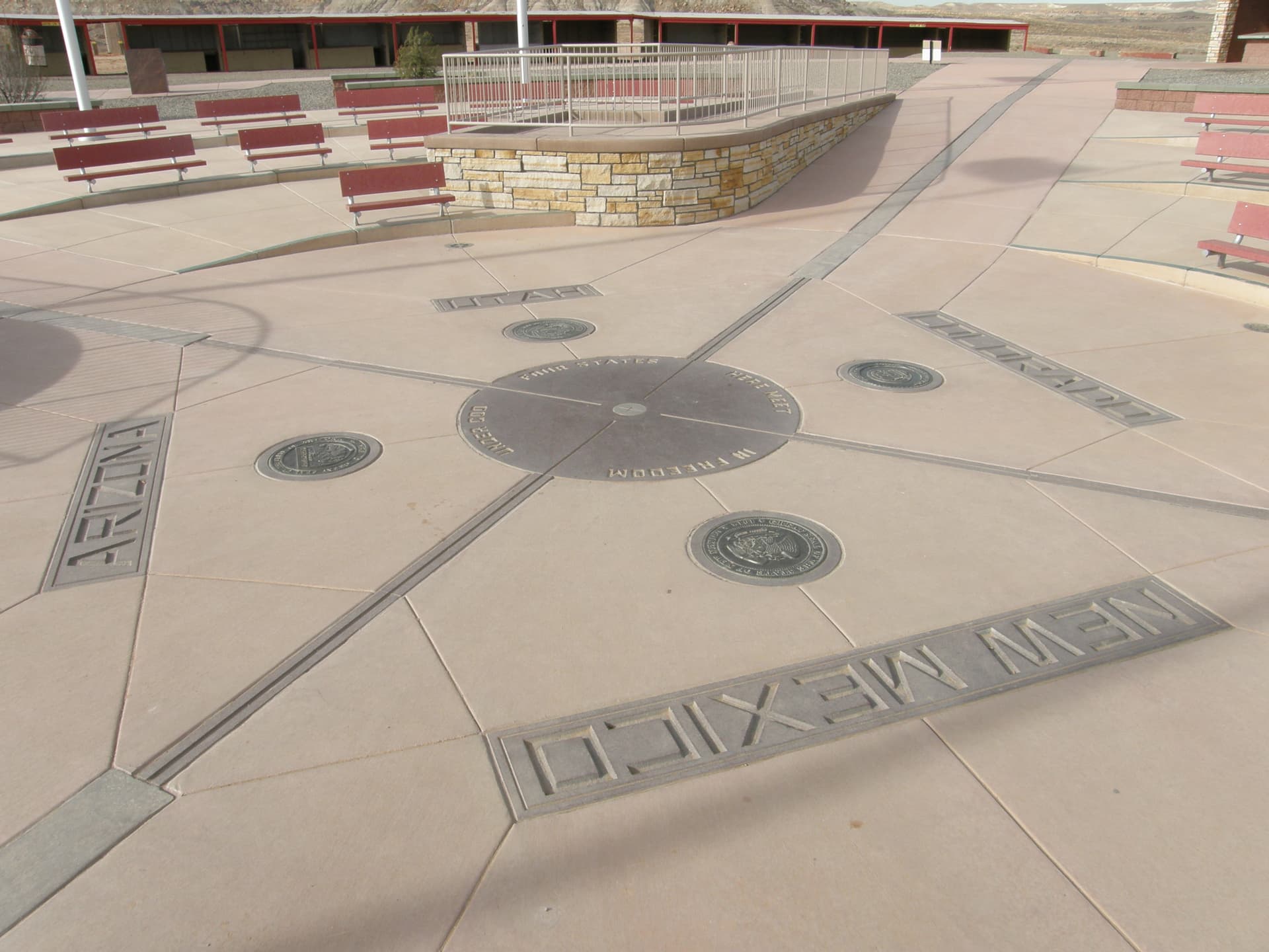
That survey history is why the landmark is famous and imperfect at the same time. NOAA says the modern monument sits about 1,350 to 1,800 feet from the mathematically exact point where the four state lines meet, a gap that reflects the limits of 19th-century surveying. Modern GPS surveys have since placed the coordinates with inch-level or better accuracy. The result is a monument that is both a tourist icon and a lesson in how frontier mapping worked long before today’s precision tools.
A place shaped by sovereignty as well as scenery
Four Corners is more than a novelty at the edge of four states. It sits inside a wider sovereignty map that includes the Navajo Nation and the Ute Mountain Ute Tribe, which is part of why the site carries cultural weight beyond the snapshot. The monument’s managed, park-like setting is not accidental. It reflects a place where tribal governance, tourism and public ritual all overlap.
That context also explains why the site feels different from a rest stop or a museum plaza. The traveler is standing on Indigenous land, at a location tied to Native and federal survey history, and in a marketplace where Navajo artisans sell work directly to the public. The visit is brief, but the setting is layered.
Why Apache County benefits, and where the value goes
Four Corners draws the kind of foot traffic that rural places depend on, but the money does not all stay in one place. Some of it goes directly to the vendors who set up at the monument. Some of it goes to the food sellers serving frybread and Navajo tacos. Some of it leaks outward into the broader border corridor, where travelers need fuel, supplies and other services that the monument itself does not provide.
That is the economic tension at the heart of the site. Apache County has one of Arizona’s most visually distinctive stretches of land, but the county also has long distances between services and few dense commercial hubs in the far north. Four Corners captures attention because it is instantly recognizable, yet the county’s ability to fully capture the value depends on how much spending stays in the immediate park and how much moves on to nearby stops before travelers continue across the high desert.
The Navajo Nation’s report on a restroom upgrade at Four Corners Monument Navajo Tribal Park shows that the visitor load is real, not symbolic. A site that handles about 250,000 annual visitors needs upkeep, and the need for infrastructure is part of the story of every rural tourism landmark. In Apache County, that makes Four Corners both a destination and a test of whether the borderland can convert visibility into lasting local revenue.
For Apache County, the monument works because it is more than a place to stand in four states at once. It is a working stop in a remote economy, where geography, Native commerce and travel routines meet in a few square feet of granite, brass and pavement.
This article was produced by Prism’s automated news system from verified source data, official records, and press releases, then run through automated quality and moderation checks before publishing. The system is built and supervised by the people who set the standards it runs under. Read our full AI policy.
Did this article answer your question?