How Atchison County’s townships shape property, elections and rural addresses
Atchison County’s township map is more than lines on paper: it points you to roads, parcels, elections and rural addresses, from Benton to Mount Pleasant.
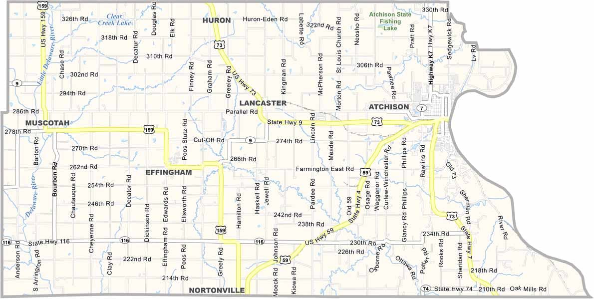
Atchison County’s administrative township map shows Benton, Center, Lancaster, Grasshopper, Shannon, Kapioma, Walnut and Mount Pleasant, along with the incorporated communities of Atchison, Effingham, Muscotah, Lancaster and Huron. If you live in Atchison County, your township is often the fastest way to place a rural address, understand a road reference, or figure out which local layer of government is in play.
Which township are you in, and why does it matter?
A 2019 Kansas Legislative Research Department briefing says Kansas townships are the most local form of government in rural areas and provide limited self-government with only the powers granted by statute. Voters in a township elect a trustee, clerk and treasurer, which is why township lines still show up in local government conversations even when most day-to-day business is handled elsewhere.
In Atchison County, that matters because the county is a mix of city, small-town and rural landscape. A parcel near Atchison may be described very differently from one near Muscotah or a farm road in Shannon Township, even when the properties are close on the ground. Township names help separate those references, especially when people are talking about land, roads or local responsibility rather than just a mailing address.
What the township map tells you at a glance
The county’s administrative townships map breaks Atchison County into named pieces and places the incorporated communities on the same frame. That makes the relationship between town, township and rural land easier to see.
One version of the map is labeled with a July 2008 aerial date and cites data from Atchison County Appraiser Geographic Information Systems, Kansas Geospatial Commons and U.S. Department of Agriculture aerial photography. It is grounded in parcel-level geography and aerial imagery for orienting around a road, field or address.
Why property, roads and addresses lean on township lines
Township boundaries help explain why two nearby rural properties can sit in different local geography references. They also help explain why some roads are described in township terms instead of city-street terms, especially outside Atchison, Effingham, Muscotah, Lancaster and Huron.
The 2019 Kansas township briefing says township officials have responsibility for township matters such as roads and other duties defined by state statute. That is the context when residents are talking about a rough stretch of roadway, a ditch issue or a route that falls outside city limits.
How to use the county’s map tools
Atchison County keeps a public Maps page and a map index. The county also maintains a public-facing GIS-style township-and-range map and a city-limits map, both of which help place a parcel or address in the county’s broader geography.
If you are trying to match an address to a legal land description, the Kansas Public Land Survey Finder is the state tool that looks up section-township-range information tied to addresses or locations. For historical context, the Kansas Department of Transportation also maintains a Historic County Township Maps resource, which gives a wider view of how county township geography has been recorded over time.
The county’s old settlement pattern is still visible on the map
An 1878 Kansas State Board of Agriculture report on Atchison County traced the county’s first settlements to the same geography that still appears on today’s township map. It placed the City of Atchison’s first settlement in August 1854 by George T. Challiss, Shannon Township’s in about July 1854 by David Fizer and Joseph Gilbert, Lancaster Township’s in November 1854 by Charles Wilson, Grasshopper Township’s on September 28, 1854 by Jacob Reese, Center Township’s in October 1854 by Caleb May, and Kapioma Township’s in February 1855 by R. A. VanWinkle, Thomas Wood and Abraham Cline.
A separate county-history reference lists an 1887 county map and 1903 plat maps for the county.
Why it still matters in a county of 16,348 people
The 2020 census counted 16,348 people in Atchison County, where the lines between city, township and rural land are part of how residents describe where they live, how roads are maintained and how local government is organized.
This article was produced by Prism’s automated news system from verified source data, official records, and press releases, then run through automated quality and moderation checks before publishing. The system is built and supervised by the people who set the standards it runs under. Read our full AI policy.
Did this article answer your question?