1960 Anthony Burn still shapes Baker County wildfire fears
The 1960 Anthony Burn still shapes how Baker County reads the high country, and this fire season’s closures at Anthony Lakes make that history feel immediate again.
Smoke over Anthony Lakes has a way of pulling the past into the present. The lightning-started Anthony Fire grew to 1,917 acres by July 14, then 1,939 acres a day later, forcing road and area closures and evacuation orders in the same high country where Baker County still lives with the memory of the 1960 Anthony Burn. That older fire is more than a date in a history file: it still shapes how people here think about forests, roads, slopes and wildfire risk.
A familiar landscape, under pressure again
Anthony Lakes sits high in the Wallowa-Whitman National Forest, at an elevation of 7,124 feet, and it has carried more than 60 years of ski-area history. The mountain setting draws skiers, campers, drivers and hikers into the same landscape that fire crews are watching now, and that long use matters when closures hit. When access roads close around Anthony Lakes, the impact reaches beyond recreation because the routes also matter for evacuation, suppression and the simple business of getting in and out of the basin.
The Anthony Fire also showed how old fire scars still change what happens next. A Baker City Herald report noted that a 2017 fire scar helped slow the 2026 blaze, giving crews a piece of the landscape that could interrupt fire spread. That detail is easy to miss in a fast-moving fire season, but it explains why local memory about previous burns still matters when the next one starts.
What the 1960 burn left behind
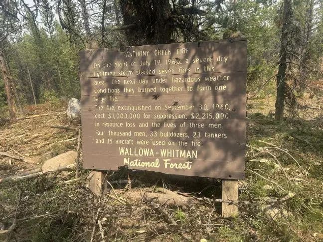
Baker County’s wildfire mitigation annex says the Anthony Fire of July 21, 1960 spread rapidly after delayed initial attack and lightning-caused ignitions. It burned more than 2,000 acres in less than two days and was about 12 miles west of Anthony Lakes campground and picnic area, placing it close enough to leave a lasting imprint on the area people now know well. A historical image archive later described the fire as a roughly 20,000-acre megafire, a sign of how large and consequential it became in regional memory.
That archive also says the fire involved the loss of a B-25 air tanker and the deaths of a pilot, a co-pilot and a U.S. Forest Service employee in a helicopter crash. Those losses give the fire a human weight that still hangs over stories told in the hills above Anthony Lakes. For Baker County residents, the burn is not just a landmark event on a timeline. It is one of the defining episodes that taught the region how fast mountain fire can move when weather, terrain and fuel line up.
Why the burn still changes how locals read the land
Old fires leave marks that remain visible in the forest structure, the age and species of trees and the way people describe a place. Around Anthony Lakes, that means the 1960 burn still helps explain why some slopes look younger, patchier or more open than surrounding ground. It also helps explain why locals think about access differently here than they might in lower, flatter country: roads are not just conveniences, they are part of the fire equation.
The same is true for slope management. Steep terrain around Anthony Lakes shapes how fire runs uphill, how crews move equipment and where smoke and heat can make suppression more dangerous. That is why a burn from 1960 still matters in 2026, even for people who never saw the original fire. The land itself carries the lesson, and the lesson is tied to the way roads, cut slopes and forest edges break up fire behavior in the high country.
What the current fire season makes plain
The 2026 Anthony Fire brings that history into sharper focus because it is burning in the same broader landscape that contains Anthony Lakes Mountain Resort and the Wallowa-Whitman National Forest. With lightning as the ignition source, evacuation orders increasing and closures spreading, the fire is forcing residents to think about the same practical questions their predecessors faced: which roads stay open, which slopes are vulnerable and how much warning is enough when fire starts in steep country.
That is where the 2017 fire scar matters again. It slowed the 2026 fire in places, showing that yesterday’s burn can become today’s break in fuel continuity. In Baker County, that kind of detail is not academic. It helps explain why land managers care about patchwork burns, why residents remember old fire boundaries and why the 1960 Anthony Burn still feels present when new smoke rises over Anthony Lakes.
What Baker County carries forward
The enduring lesson from Anthony is not that fire can be prevented by memory alone. It is that memory changes behavior. People who know this country have long understood that forest access, road placement, slope exposure and wildfire risk are tied together, and the 1960 burn is one of the reasons that understanding runs so deep.
As this fire season unfolds, Baker County is seeing the same mountain ground through two timelines at once: the immediate one of closures, evacuations and active flames, and the longer one written into the trees, the scars and the routes around Anthony Lakes. That overlap is why the 1960 Anthony Burn still matters. It continues to shape how the county reads danger in the high country and how it prepares for the next fire that finds the same slopes.
This article was produced by Prism’s automated news system from verified source data, official records, and press releases, then run through automated quality and moderation checks before publishing. The system is built and supervised by the people who set the standards it runs under. Read our full AI policy.
Did this article answer your question?