Bike Baltimore map highlights the city’s best rideable routes
Baltimore’s bike map links waterfront parks, landmark corridors and calmer streets, but it also shows where the city still rides in pieces.
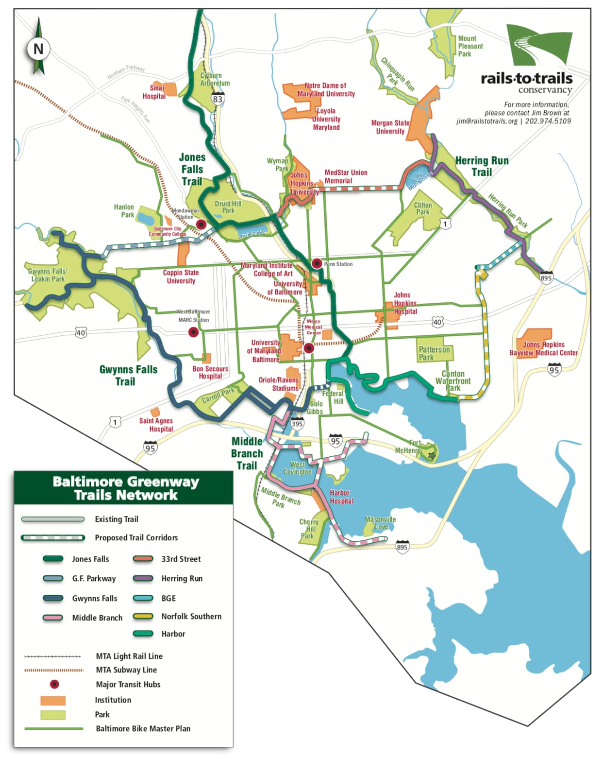
Baltimore’s official Bike Baltimore map turns the city into a set of rideable connections, built around the waterfront, park corridors and neighborhoods where lower-traffic streets can carry bikes and cars together. For anyone trying to move across Baltimore without a car, it is a practical guide to where a ride feels continuous and where it still takes planning.
What the map is built to show
The city describes the map as a “two-wheel perspective” on Baltimore, one that helps cyclists learn the city’s unique neighborhoods, picturesque parks, active waterfront and monumental landmarks. The map is not trying to promise a bike lane on every street. It identifies existing bike facilities and routes commonly used by cyclists, with a preference for lower-traffic volume areas and streets that leave enough roadway space for both cars and bikes.
The map shows a city of distinct pieces that can be linked by bike if you know where to look. A rider can move from the harbor to a park, from one rowhouse district to the next, or from a neighborhood street to a landmark corridor, but the quality of that trip depends on how well those pieces connect.
A waterfront ride that actually works
One of the most intuitive uses of the map is the waterfront itself. Rash Field, Pierce’s Park, Riverside Park and Canton Waterfront Park give cyclists a string of destinations that make sense for a weekend ride, a scenic out-and-back, or a relaxed trip between neighborhoods. The appeal is not only the view, but the fact that the map helps riders understand where the active waterfront already functions as a connected corridor.
That route also reveals a useful pattern in Baltimore cycling: the harbor area is one of the places where the city’s landscape reads most clearly on a bike. The mix of public space, landmarks and established bike facilities makes it easier to stitch together a ride without relying on high-traffic roads.
Park-to-park on the west side
A different kind of ride shows up when the map is used to link Druid Hill Park and Leakin Park. That is less of a waterfront outing and more of a city-scale green-space ride, with room for a longer weekend trip or a quieter ride away from the harbor. Baltimore’s park system can function like a chain, not just a set of isolated destinations.
This kind of route also exposes the city’s unevenness. Some stretches feel naturally rideable because they sit near parks or lower-volume streets, while other parts of the city ask cyclists to work harder to connect the dots. The map helps riders judge whether a ride will feel comfortable for a commute, a family outing or a longer training loop.
A longer ride toward the city’s edge
Lake Roland Park gives the map another kind of destination, one that pushes toward the city’s edge and shows how Baltimore connects to nearby green space beyond the dense urban core. Even without treating it as a single fixed route, the map helps riders think about how to build a longer ride that moves from city streets into a park setting. It is useful for cyclists who want distance, not just a short errand run.
This is where the map’s lower-traffic focus becomes especially important. Longer rides are easier to enjoy when the route uses streets with enough space for bikes and cars to coexist, rather than forcing riders onto fast or crowded corridors.
Why the map fits Baltimore’s larger bike planning
The Bike Baltimore map sits inside a longer planning history. Baltimore City’s 2015 Bicycle Master Plan, dated March 2015, was prepared for the Baltimore City Department of Transportation by McCormick Taylor, Inc., with assistance from Sabra, Wang & Associates, Inc. The city’s new bike master plan set a goal of 253 miles of bike lanes and trails by 2028, a target that drew cautious reviews.
The map also fits with ongoing city and civic work. Bikemore works closely with the Baltimore City Department of Transportation to monitor and advise on bicycling infrastructure plans and improvements, while the city keeps a Bike Baltimore page, a Bicycle Master Plan and Maps page, and a Mayor’s Bicycle Advisory Commission page on its own site.
The regional picture matters too
Baltimore’s bike network does not stop at the city line. Baltimore County released its first-ever countywide Bicycle and Pedestrian Master Plan on November 6, 2023, and the Baltimore Metropolitan Council treats active transportation as critical to the region’s transportation system.
This article was produced by Prism’s automated news system from verified source data, official records, and press releases, then run through automated quality and moderation checks before publishing. The system is built and supervised by the people who set the standards it runs under. Read our full AI policy.
Did this article answer your question?