Park Entrance, West Crater Rim Drive and Highway 11 Reopen; East Closed
Park entrance and Crater Rim Drive West reopened after crews cleared ash and tephra; Crater Rim Drive East and other sections remain closed due to heavy volcanic debris.
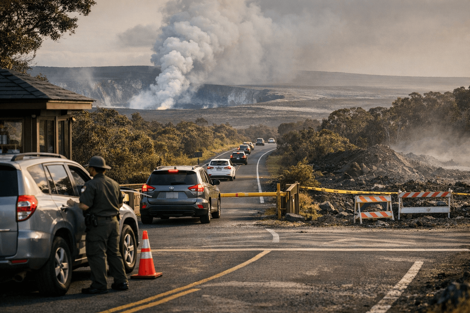
Hawaiʻi Volcanoes National Park reopened its main entrance and Crater Rim Drive West to Kīlauea Military Camp after crews cleared ash and volcanic debris, while Crater Rim Drive East and other interior sections stayed closed because of large amounts of tephra on roadways. Motorists were warned to use extreme caution as cleanup continues and rangers maintained closures and traffic control.
Hawaiʻi County officials also reported progress on public roads. The office of Mayor Kimo Alameda said Highway 11 near Volcano Village reopened at 6:24 p.m. Jan. 24 after an earlier closure prompted by ashfall and tephra from Episode 41 of the Kīlauea summit eruption. Hawaiʻi County Civil Defense and the Hawaiʻi Police Department confirmed the highway had been closed in both directions near the 24.5-mile marker at the solid waste transfer station and at the 32-mile marker inside Hawaiʻi Volcanoes National Park, and that those restrictions were lifted where crews had cleared hazards.
The eruption episode began at 11:10 a.m. Jan. 24 with lava fountains exceeding 1,600 feet in Halemaʻumaʻu crater. Hawaiian Volcano Observatory reported north and south vent fountains higher than 1,640 feet as of 12:10 p.m., and noted tephra fall in public viewing areas at Hawaiʻi Volcanoes National Park, Volcano Village, Mauna Loa Estates and ʻŌhiʻa Estates. The National Weather Service in Honolulu escalated an initial ashfall advisory to an ashfall warning in effect until 6 a.m. Jan. 25 for much of the island’s eastern, southeastern, southern and interior areas.
Public safety agencies warned of possible disruptions to water, sewer and electric services and that ash removal could require significant resources. The National Weather Service noted: "Kilauea is undergoing a eruption and we have received reports of moderate ashfall and significant amounts of tephra. We have also received reports of debris as large as a foot near Kīlauea. Satellite imagery shows a large volcanic plume drifting towards [the] Glenwood and Pāhoa area." Hawaiʻi Volcanoes National Park advised: "Light tephra continues to fall around the summit area," and added, "The safest place to observe Episode 41 is on the U.S. Geological Survey webcams."
Residents and visitors should expect staggered reopenings as crews clear heavy debris and assess road integrity. Hawaiian Volcano Observatory continues to monitor eruptive activity; Kīlauea’s Volcano Alert Level remains at Watch and its Aviation Color Code is Orange. Live webcam views are available via KPcam, MKcam and the summit webcams, and the observatory can be reached at askHVO@usgs.gov for technical questions. Park rangers remain on duty and visitors must obey all posted signs, closures and ranger directions.
For Big Island residents, reopening of Highway 11 and the park entrance restores key access for residents, emergency services and tourism, but lingering ash and tephra mean that travel, utility reliability and cleanup will continue to shape daily life in Puna, Kaʻū and the Volcano Village area in the coming days.
This article was produced by Prism’s automated news system from verified source data, official records, and press releases, then run through automated quality and moderation checks before publishing. The system is built and supervised by the people who set the standards it runs under. Read our full AI policy.
Did this article answer your question?