USGS Releases Kīlauea Maps Showing Episode 42 Lava, Tephra, Ground Deformation
USGS Hawaiian Volcano Observatory maps published Feb. 19, 2026 show Episode 42 deposits from Feb. 15 lava fountains that ran nearly 10 hours and InSAR fringes indicating summit deflation.
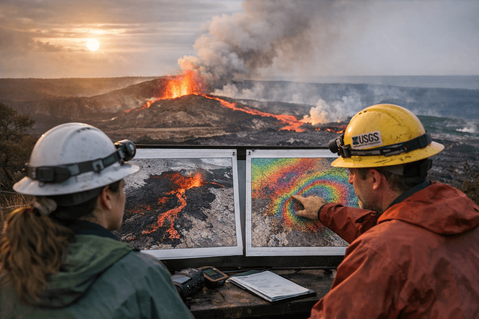
The U.S. Geological Survey’s Hawaiian Volcano Observatory released on Feb. 19, 2026 new maps documenting lava flow and tephra accumulation tied to Episode 42 of the ongoing Halemaʻumaʻu summit eruption and a Sentinel-derived interferogram covering Feb. 10–16, 2026 that shows summit deformation. Episode 42 produced lava fountains at the summit on Feb. 15, 2026 that were active for nearly 10 hours and generated new deposits mapped on the crater floor and to the southwest of Kaluapele (Kīlauea summit caldera).
“This map shows lava flow and tephra accumulation at the summit of Kīlauea volcano associated with episode 42 of the ongoing eruption in Halemaʻumaʻu that started on December 23, 2024, using data recorded by the Italian Space Agency’s (ASI) COSMO-SkyMed Second Generation satellite constellation,” USGS explained in the map caption text released with the graphics.
The maps combine cross-polarized radar amplitude imagery and interferometric coherence to isolate lava and tephra across weather and surface conditions. USGS used COSMO-SkyMed Second Generation radar amplitude images acquired on Feb. 2 and Feb. 18, 2026 and computed interferometric coherence between those dates; the deformation image was produced from European Space Agency Sentinel-1A/C data spanning Feb. 10–16, 2026. In the radar-amplitude maps unchanged barren areas appear blue/purple, vegetated areas appear yellow/light green, and new deposits over barren land are shown dark green. Map symbology marks lava flows covering the crater floor with a pink polygon and the two vents as purple circles.
The Sentinel interferogram uses a color cycle that represents 2.8 cm (1.1 in) of range change in the satellite-to-ground direction. USGS notes that the interferogram spanning Episode 42 shows round fringes within and around Kaluapele indicating ground-surface deflation interpreted as magma withdrawal from the Halemaʻumaʻu magma chamber. The map inset includes a symbol in the upper left indicating the satellite orbit direction (arrow) and look direction (bar).
Public-safety information accompanies the maps: the episodic eruption is occurring within a closed area of Hawaiʻi Volcanoes National Park and the caldera rim surrounding Halemaʻumaʻu has been closed to the public since late 2007. USGS warns of caldera wall instability, ground cracking, rockfalls enhanced by earthquakes, and tephra on the crater rim prone to cracking and slumping that can expose hot or molten material. The agency advises caution for days after episodes because lava on the Halemaʻumaʻu crater floor and the southwest side of Kaluapele can remain hot and may slowly move.
Operational notes on monitoring are included: USGS lists Kīlauea webcam images, three summit livestream videos, recent lava-flow maps, FAQs, and a timeline of episodes since the eruption began Dec. 23, 2024. The V3 summit camera is experiencing data issues and USGS has ordered a replacement following Episode 42. For the Kīlauea activity summary phone (808) 967-8862 is provided.
The Episode 42 maps build on USGS monitoring products issued since the eruption began: a Kīlauea summit eruption reference map was posted Nov. 25, 2025, a tephra map for Episode 41 was posted Jan. 24, 2026, and earthquake and deformation maps were posted in January and February 2026. USGS has previously used the same radar/InSAR approach to map earlier episodes, noting in prior examples that fountains reached as high as 1,200 ft (365 m) and tephra has traveled nearly 2 miles (3 km) from vents during intense summit episodes. The new Feb. 19, 2026 maps provide the spatial detail needed to assess post-episode hazards and to guide continued monitoring of Kīlauea.
Know something we missed? Have a correction or additional information?
Submit a Tip

