Glacial Trail Scenic Byway showcases Buena Vista County’s glacier-carved landscape
A northwest Buena Vista County loop pairs glacier-cut bluffs, prairie remnants and county park lodging with easy stops in Newell, Peterson and Linn Grove.
A drive on the Glacial Trail Scenic Byway turns a few hours in northwest Buena Vista County into a real outing. The route gives you glacier-cut bluffs, prairie remnants, a lake stop, and a county park base all within reach of home, so a half day can easily stretch into a weekend.
A byway built around land, memory and a short drive
The Glacial Trail Scenic Byway is a 36-mile loop through O’Brien, Clay, Buena Vista and Cherokee counties, and Buena Vista County sits in the part of the route that makes the strongest case for lingering. Designated a state byway in 2000, it belongs to Iowa’s larger network of 11 state-designated and three nationally designated scenic byways, a reminder that the county is part of a bigger travel system built around nature, history and culture.
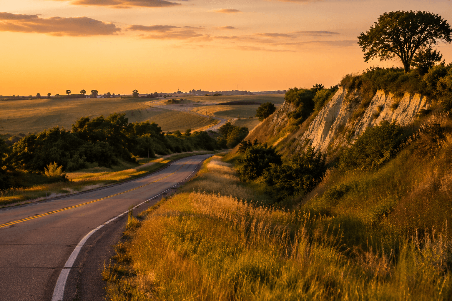
The route ties together Iowa’s agricultural roots, Native American history and a glacier-carved landscape. In this corner of the state, the Little Sioux River Valley gives the byway its shape, with steep bluffs, terraces and a deep valley form that came from glacial blockage rerouting drainage across northwest Iowa. Near the Buena Vista, Cherokee, Clay and O’Brien county corner around Peterson, the topography became especially dramatic when a glacial ice dam broke, leaving the kind of landforms that make the drive worth taking in every season.
Use Buena Vista County Conservation Park as your base
The easiest place to anchor a day trip is Buena Vista County Conservation Park, just off the byway on 400th Street, two miles east of M-27 in the Little Sioux River Valley of northwest Buena Vista County. The campground is seasonal, open from May 1 to October 1, and Timber Ridge Campground includes 23 electrical hookups along with showers and water and sewer hookups. Primitive camping is also available, so the park works whether you want a simple overnight or a more comfortable setup.
The park has enough built-in amenities to carry a full day on its own. Nine hiking trails, picnic shelters, an enclosed shelter house, an arboretum, wildlife viewing, native grasses and wildflowers, a tubing hill and playground equipment make it easy to split time between quiet walking and family-friendly stops. The North Lodge, completed in 2020, sleeps 8 to 10 people and rents for $150 a night plus tax, while the rustic oak log cabin sleeps 10 to 12 and rents for $125 a night plus tax.
Buena Vista County’s conservation system is substantial enough to support that kind of visit. One county listing says the board manages 17 areas containing more than 1,200 acres of parks, wildlife refuges, historic sites and natural areas, while MyCountyParks lists 18 areas totaling more than 1,145 acres. A five-member volunteer board oversees the system, which helps explain why the county has the kind of public-land footprint that can support both short drives and longer stays.
A practical stop order for a half day
If you want the route to feel local instead of just scenic, start at Buena Vista County Conservation Park, then work outward. A morning walk on the park’s trails gives you the valley setting up close, and lunch can happen at one of the picnic shelters or inside the enclosed shelter house if the weather turns. After that, head toward Newell and then on toward Peterson and Linn Grove to see how the byway threads the county’s small towns into the larger landscape.
The point is not to rush through the route but to keep your day tied to places where the county’s public land, trail access and town grid still matter. That is the part of the byway that keeps travel dollars close to home: campground fees, cabin rentals and day-use time all connect back to Buena Vista County’s own conservation system and to nearby communities along the loop.
Add Sturchler Pit and Browns’ Prairie to the route
Near Newell, Sturchler Pit Area gives the byway a very different kind of stop. The former 120-acre gravel pit now holds a lake and recreation area with a swimming beach, picnic shelters, playground equipment, prairie plots and a trail around the pit. The county park page adds a boat ramp, and Iowa Department of Natural Resources fish data narrows the lake to 15 acres with a maximum depth of 18 feet, electric motors only and a gravel boat ramp.
That makes Sturchler Pit a useful hour-long detour whether you want to fish, walk the trail or let kids stretch before the next leg of the drive. It is not a grand overlook; it is a practical stop, the kind that gives a local byway real value because it offers something usable, not just something to photograph.
Farther along the valley, Browns’ Prairie near Peterson puts the landscape into sharper historical focus. The 188-acre tract sits inside one of the largest complexes of remnant prairie left in Iowa, and the Little Sioux Valley region around it contains more than 3,000 contiguous acres of prairie. That matters in a state where Iowa once supported more than 30 million acres of prairie and less than one-tenth of 1 percent remains.
The valley also carries a deeper human timeline. Mill Creek culture sites run along the Little Sioux River and its tributaries in Cherokee, O’Brien and Buena Vista counties, and the culture is generally dated to about 1100 to 1250 CE. Seen together with the prairie and the glacial landforms, those sites show why this byway is more than a backroad: it is a route through geology, ecology and Indigenous history at the same time.
Why the county segment stands out
Buena Vista County’s stretch of the Glacial Trail Scenic Byway works because it combines public access with a landscape that still feels legible. The county park gives you hiking, camping and lodging in one place, Sturchler Pit adds water access and a quick recreation stop, and Browns’ Prairie anchors the route in one of the state’s most important remaining prairie landscapes. With Peterson, Linn Grove and Newell on or near the loop, the drive keeps one foot in small-town Iowa and the other in a valley shaped by ice, water and time.
This article was produced by Prism’s automated news system from verified source data, official records, and press releases, then run through automated quality and moderation checks before publishing. The system is built and supervised by the people who set the standards it runs under. Read our full AI policy.
Did this article answer your question?