Severe thunderstorm warning covers Storm Lake, Alta until 4 a.m.
Storm Lake, Alta and Cherokee stayed under a warning until 4 a.m. as a fast-moving storm brought ping-pong-ball hail and 68 mph gusts near Storm Lake Airport.
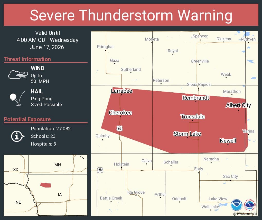
A severe thunderstorm warning kept Storm Lake, Alta and Cherokee under alert until 4 a.m., with the strongest part of the storm already tracking east at 60 mph before sunrise. At 3:36 a.m., the storm was 7 miles north of Alta, or 10 miles northwest of Storm Lake, and the warning called for ping-pong-ball-size hail.
That combination of hail and fast-moving wind made the pre-dawn hours the most dangerous stretch for Buena Vista County residents trying to get through early-morning travel, check on property or start the commute. A 68 mph wind gust had already been reported near Storm Lake Airport, a sign that the storm was capable of brief but damaging bursts as it moved through northwest Iowa.

Storm Lake, Alta and Cherokee were all included in the warning area, putting a wide swath of the county and neighboring communities in the storm’s path. With the line moving east, the hazard to roads, trees and exposed vehicles remained highest through the remainder of the warning period before daybreak.
The severe weather threat was part of a larger overnight pattern across northwest Iowa. National Weather Service Sioux Falls said strong to severe storms were expected Tuesday afternoon and evening, with damaging winds, large hail and a few tornadoes possible. The office issued a Hazardous Weather Outlook at 9:18 p.m. June 16, then showed active watches and warnings on its homepage early Wednesday morning.
The overnight warning also came against the backdrop of an active severe-weather season in the region. On May 17, storms in northwest Iowa produced wind gusts up to 82 mph through the Sioux City-to-Cherokee corridor, a reminder that high-end wind events have already hit parts of Cherokee County and surrounding communities this spring.
For residents across Buena Vista County, the immediate concern before daybreak was simple: keep an eye on the sky, protect vehicles from hail, and treat any sudden increase in wind or visibility loss as a sign the storm was worsening.
This article was produced by Prism’s automated news system from verified source data, official records, and press releases, then run through automated quality and moderation checks before publishing. The system is built and supervised by the people who set the standards it runs under. Read our full AI policy.
Did this article answer your question?


