Sand Canyon Pueblo offers a vivid window into Dolores County's past
Sand Canyon Pueblo packs Ancestral Pueblo history, a short walk and clear stewardship rules into one Dolores County visit.

Just outside Dolores, Sand Canyon Pueblo turns a short walk into a direct encounter with Ancestral Pueblo history. The trail is close enough for a day trip, yet layered enough to feel like a real field lesson, with excavated rubble mounds, interpretive signs and a landscape that still carries the shape of a large village.
A village that was once a major center
Sand Canyon Pueblo sits within Canyons of the Ancients National Monument, a landscape the Bureau of Land Management created on June 9, 2000, through presidential proclamation. The monument covers 176,056 acres of public land, and the agency describes it as having the highest known density of archaeological sites in the United States, with more than 8,300 documented sites and estimates of more than 30,000 more still to be recorded.
That wider setting matters because Sand Canyon was not a minor outlier. The Bureau of Land Management says the pueblo was about three times the size of Cliff Palace by AD 1275, a comparison that gives immediate scale to what visitors are standing beside. The monument itself stretches across Colorado’s Great Sage Plain, a high, dry plateau that BLM calls a living cultural landscape for 26 tribes and pueblos.
What you can see on the ground
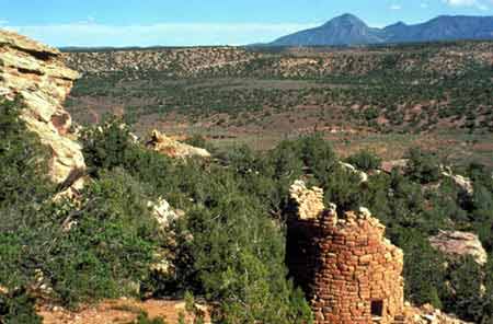
Colorado.com identifies Sand Canyon Pueblo as an ancient Pueblo Indian village near Dolores at 27501 Highway 184, where a walking trail leads past excavated rubble mounds and interpretive signs. That makes the site unusually accessible for families, local school groups and visitors who want to see archaeology without committing to a long backcountry hike.
The physical remains are substantial. Crow Canyon Archaeological Center’s site database describes Sand Canyon Pueblo as having approximately 420 rooms, 90 kivas, 14 towers, an enclosed plaza, a D-shaped bi-wall structure and a great kiva. Those features show that the site was a large community with planned architecture, not just a scattering of isolated rooms in the dirt.
Crow Canyon places the earliest construction at about AD 1250, with building continuing into the 1260s and at least to 1271. The latest tree-ring date is AD 1277vv, which suggests activity may have continued until then or shortly afterward. The Sand Canyon Archaeological Project, which ran from 1983 to 1993, focused on Pueblo III settlement from about A.D. 1150 to 1300 in the central Mesa Verde region, with Sand Canyon Pueblo as a major component.
Why the site still looks preserved
The ruins you see today are not an accident of neglect. Colorado trail materials say researchers excavated several rooms from 1983 to 1993 and then backfilled them to protect standing walls and preserve the site. That choice allows visitors to read the structure of the village while reducing damage to fragile remains.
That balance between access and protection is one of the reasons Sand Canyon works so well as a Dolores County history stop. The site is visible enough to tell a story, but managed carefully enough that the story is still here to tell. The walking trail gives visitors a tangible entry point into the county’s deep past without requiring a major backcountry effort.
Start at the visitor center in Dolores
The best first stop is the Canyons of the Ancients Visitor Center and Museum in Dolores, located at 27501 Highway 184. BLM describes it as the premier archaeological museum in Southwest Colorado and the headquarters for the monument, and visitor materials say it curates more than 3.5 million artifacts and records.
The museum’s exhibits interpret Ancestral Puebloan, historic Pueblo, Ute, Navajo and Anglo settler history, which helps place Sand Canyon in a broader human landscape rather than isolating it as a single ruin. BLM also recommends starting there for current information, exhibits, films and a hands-on discovery area. It is also just 17 miles from Mesa Verde National Park, making it an easy companion stop for anyone comparing the region’s great cliff dwellings with the broader village networks that once filled this part of the Four Corners region.
How to visit with care
Sand Canyon is rewarding, but it is not a casual stroll with no rules. BLM trail materials say the area supports hiking, mountain biking, horseback riding and viewing archaeological sites only on designated routes. The same materials warn that Sand Canyon is not a beginner trail, because some switchbacks climb 700 feet in less than half a mile.
That steep terrain is one reason the site deserves extra care from every visitor. Stay on signed trails, keep to designated access and do not treat walls, rubble mounds or excavated areas as places to climb, sit or move through. The monument brochure also says cross-country motorized travel is not allowed, a rule that protects both the archaeological record and the fragile ground cover that holds the landscape together.
A good visit means noticing the details that make the site legible without disturbing them: the mound outlines, the interpreted rooms, the trail alignment and the way the village sits within the larger canyon country. It also means leaving everything in place. Even small changes can erase information that archaeologists, tribal partners and land managers still rely on to understand how people lived, built and adapted here.
A living landscape, not a relic
Canyons of the Ancients is more than a collection of ruins. BLM calls it a living cultural landscape, and that description fits Sand Canyon Pueblo as well. The site carries evidence of a large community, a long construction history and a careful recovery effort that kept the remains visible while protecting what survives.
For Dolores County, that makes Sand Canyon Pueblo one of the most accessible hands-on history lessons in the region. It is close, walkable and legible, but only if visitors treat it as a protected place, not an open-air exhibit to handle.
This article was produced by Prism’s automated news system from verified source data, official records, and press releases, then run through automated quality and moderation checks before publishing. The system is built and supervised by the people who set the standards it runs under. Read our full AI policy.
Did this article answer your question?


