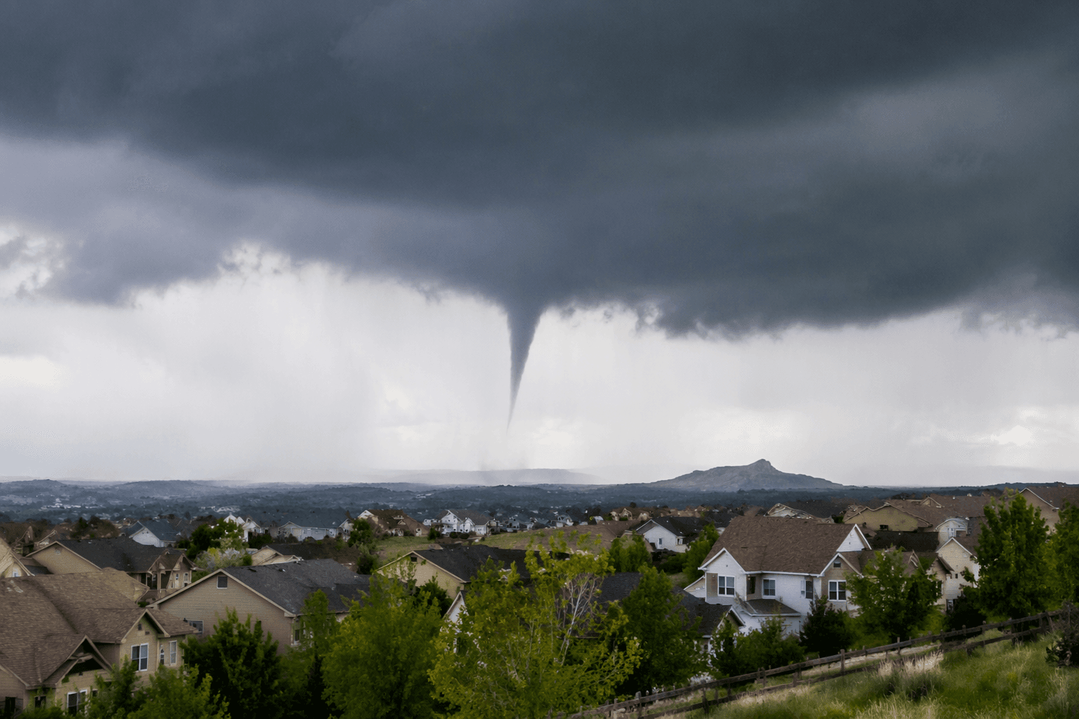
Funnel cloud spotted over Castle Rock as severe storms pound metro area
A funnel cloud was spotted over Castle Rock around 1:30 p.m. as hail and warnings spread across Douglas County and the metro area.
A funnel cloud hung over Castle Rock around 1:30 p.m. as powerful storms rolled through the Denver metro area, sending drivers under highway overpasses and dropping large hail across parts of the region.
The sighting came amid a fast-moving severe-weather setup that covered much of the Denver/Boulder forecast area. By later in the day, the National Weather Service office in Denver/Boulder showed an active mix of severe-thunderstorm warnings, severe-weather statements, a severe-thunderstorm watch, a flood advisory and a special weather statement, a sign of how broad the storm threat became across the metro area and surrounding counties.
Douglas County was not on the fringe of the system. The weather service maintains a dedicated Douglas County page for localized warnings, radar and advisories, including severe, flash flood, winter weather, high wind and fire weather products. That kind of county-level alerting matters when conditions can change in minutes, especially in places like Castle Rock where a funnel cloud can appear while hail is already falling elsewhere nearby.
June is peak severe-weather season in Denver, when thunderstorms can bring large hail, damaging wind gusts, heavy rain and sometimes tornadoes. The storm on Monday fit that pattern. Large hail was reported, and the image of motorists pulling under overpasses highlighted how quickly people were trying to find cover as the weather intensified.
That reaction can be dangerous. Overpasses are not a safe place to shelter during severe storms because wind can accelerate through the structure and leave drivers exposed. The safer move is to get off the road and into a sturdy building or designated shelter before hail, strong winds or a possible tornado reach your location.
The weather service’s archive shows that June severe weather is hardly unusual for the Front Range. Its history for June 1 notes hail as large as 1 1/2 inches in west Denver in 1961, with hail up to 1 1/4 inches reported in Derby. That history is a reminder that the region’s hail risk is recurring, not rare, and that the first dark clouds over Douglas County can signal a much bigger threat fast.
This article was produced by Prism’s automated news system from verified source data, official records, and press releases, then run through automated quality and moderation checks before publishing. The system is built and supervised by the people who set the standards it runs under. Read our full AI policy.
Did this article answer your question?