Ferdinand State Forest map shows trails, lakes and visitor access
Ferdinand State Forest packs nearly 10 miles of trails, two named lakes and a seasonal gate into one Dubois County outing. Knowing the gatehouse access keeps a trip on track.
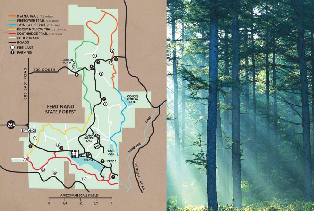
The official map of Ferdinand State Forest marks the gatehouse, parking areas, Fossil Lake, Lake Coyote Hollow, trails, campground and beach, and it makes one access rule explicit: when the seasonal gate is operating, recreation area access is via the gatehouse only.
What the map puts on the ground
The Indiana Department of Natural Resources map marks the entrance, office, gatehouse, parking areas, picnic shelter, vault toilets, hiking trails, connector trails and the Lake Service Area, along with the campground, boat launch, boat rental, beach, swimming area, fire tower and fishing areas. It also labels tree cover types, including maple, tulip and pine.
The map identifies Fossil Lake and Lake Coyote Hollow, which makes the forest easier to use for fishing, paddling, swimming or choosing a spot for a family stop.
How to plan a first visit
Access is the detail that most changes a day at Ferdinand. The seasonal gate affects arrival time, parking, how you reach the lake area, and whether you can simply drive to the part of the forest you want to use.
The property address is 6583 East State Road 264, Ferdinand, IN 47532, and the office phone number listed on the map is 812-827-2857. Those details are worth having before you leave home if you are heading in for a hike, looking for the lake access points, or trying to confirm whether the gate is affecting your route. A map in hand, or loaded on a phone, is the easiest way to keep the visit efficient.
Trails for hiking, biking and mixed use
Ferdinand has nearly 10 miles of challenging multiple-use trails, so this is not a place where every path feels the same. The trail system includes hiking trails and connector trails, which makes it possible to build a short outing or a longer circuit depending on how much ground you want to cover. The map’s multiple-use design also means the trails are shared space, not a single-purpose path network.
Trail rules matter here. Bikers should yield to hikers, and only non-motorized bicycles are permitted. An off-road cycling permit is required and can be obtained at the office, so riders need to handle that before heading out. During hunting season, trail users are advised to wear bright-colored clothing, a practical reminder that the forest stays active and shared even when the woods look quiet.
For families, the most useful trail approach is to think in terms of comfort and access rather than mileage alone. The map’s parking areas, picnic shelter and vault toilets make shorter outings easier to manage, while the connector trails help more experienced hikers stretch a visit beyond a simple out-and-back walk. If the goal is a straightforward morning outdoors, the marked day-use features reduce the chance of ending up too far from the car or the lake area.
Lakes, day-use spots and what they support
Fossil Lake and Lake Coyote Hollow anchor much of the recreation experience at Ferdinand. The map also shows the Lake Service Area, campground, boat launch, boat rental, beach, swimming area and fishing areas, so visitors can match the trip to the activity instead of improvising once they arrive. That is especially helpful for families with mixed interests, where one person may want to fish while another wants the beach or a short walk.
The fire tower is a landmark that helps orient first-time users. Combined with the parking areas and clearly labeled facilities, the site works more like a planned recreation complex than an unmarked patch of public land.
The tree cover labels also help set expectations. Maple, tulip and pine areas suggest a forest with varied texture, not a uniform stand of trees, which matters when planning hikes, photography or a quiet stop around the lake.
Why Ferdinand exists in the first place
The forest’s story begins with a local conservation club, not a distant agency. In 1933, the club raised money to buy 900 acres to build a lake and establish an area to hunt and fish. The following year, it offered management of the project to the Indiana Department of Conservation, and Ferdinand State Forest took shape as a state-managed outdoor area from there.
The forest was established in 1934 and is listed by the Indiana Department of Natural Resources as 7,700 acres. The current trail map and property page show where the land’s recreation features are and how visitors access them.
This article was produced by Prism’s automated news system from verified source data, official records, and press releases, then run through automated quality and moderation checks before publishing. The system is built and supervised by the people who set the standards it runs under. Read our full AI policy.
Did this article answer your question?