Goochland County grew from frontier settlement to modern community
Goochland’s old river-and-road corridors still steer where homes, jobs and traffic go, even as the county nears 30,000 residents.
Goochland County’s past is not sealed off in a history book. The same river access, road patterns and settlement lines that first drew people here now still shape where the county grows, where commuters drive and where new development pressure lands. With the population estimated at 29,187 in July 2025, Goochland is balancing a frontier-era footprint against modern housing, traffic and land-use decisions.
From Indigenous homeland to colonial county
Long before Goochland became a county, the James River Valley was home to the Monacan Tribe, with Rassawek at Point of Fork serving as a central place in that landscape. The Monacan Indian Nation is now a state- and federally recognized tribe near Bear Mountain in Amherst County, and its original territory, along with that of its allies, covered more than half of present-day Virginia, including almost all of the Piedmont and parts of the Blue Ridge Mountains.
By 1700, the Monacans had moved westward and Huguenot settlers had entered the Goochland area, including the abandoned village of Manakintown. Their settlement at Manakin Town was part of an early colonial experiment on the frontier, placed in part as a buffer against potential attacks by Native Americans. That layered beginning still matters because it explains why the county formed where it did: at a crossing point between river travel, inland settlement and the push of colonial expansion.
Goochland County was created by legislation in 1727 and formally established in 1728 with its first court. It was named for Sir William Gooch, who arrived in Virginia in 1727 and served as lieutenant governor from 1727 to 1749 after being appointed by George I. Goochland was one of only seven Virginia counties formed between 1703 and 1730, which places it among the colony’s earliest organized jurisdictions and helps show how central this part of Virginia was to westward movement.
A county that once stretched to the mountains
The county’s early footprint was far larger than the one residents know today. Goochland once extended from Tuckahoe Creek on both sides of the James River all the way to the Blue Ridge Mountains, a span that made it a true hinge between the coastal plain and the interior. That geography did not stay static for long.
Albemarle County was carved from Goochland’s western portion in 1744, and Powhatan County was created south of the river in 1748. Those boundary shifts show how Virginia’s county map was built in pieces as settlement moved outward, and Goochland’s size changed as new communities took shape around it. The county’s present identity still carries that older shape in its roads, river crossings and development corridors.

That same geography also explains the county’s changing economy. Goochland’s own materials note that agriculture is no longer the dominant industry, the James River is no longer a major commercial highway and gold and coal mining belong to an earlier era. The county’s tourism materials say coal was discovered in the Manakin area in 1701 and mined there from the early 1700s until the 1880s, showing how long the land’s resources shaped local work.
River commerce, canal power and rail-era change
Transportation corridors changed Goochland just as much as county lines did. By 1840, the James River and Kanawha Canal was operating in Goochland, and the county contains 25% of the canal’s original total length. That canal tied the county more tightly to Richmond and to the river economy that moved goods through central Virginia.
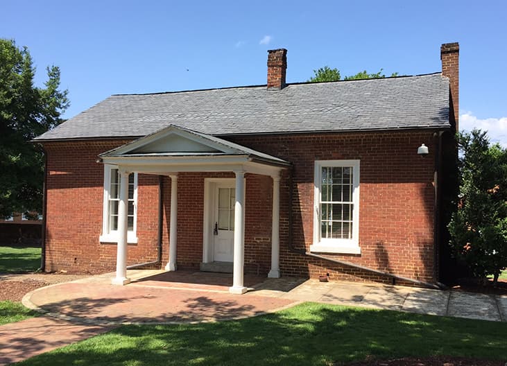
The Lock-Keeper’s House in Goochland, built about 1836 for Lock No. 7, captures that era in one building. It served for changing horses, checking invoices, collecting tolls and lodging passengers and canal crews, and it is described as the last remaining lock-keeper’s house in the James River and Kanawha Canal system and believed to be the only such building standing in Virginia. During the Civil War, the canal also moved pig iron and coal toward Richmond, underscoring how this corridor served both commerce and wartime supply.
The railroads then rewrote the county’s transportation map. By 1880, the Richmond and Allegheny Railroad had bought the canal right-of-way and laid tracks on the towpath, replacing water power with rail transport along the same corridor. Granite mining in Manakin began in the late 1800s after the railroad arrived, another sign that new infrastructure did not erase old economic patterns so much as redirect them.
Why the old map still matters now
Those historic layers are not just interesting background. They help explain why Goochland’s current growth conversations keep circling back to the same corridors that carried Indigenous travel, colonial settlement, canal commerce and rail traffic. The county’s geography continues to influence development even as residents face modern questions about where housing should go, which roads need capacity and how much land should stay open or agricultural.

The numbers show why that pressure is real. The U.S. Census Bureau estimated Goochland County’s population at 28,223 in July 2024 and 29,187 in July 2025, increases of 14.1% and 18.0% from the April 2020 census base. For a county that once stretched to the Blue Ridge, that growth means the old settlement pattern is now being asked to carry more cars, more homes and more public services.
Goochland’s 2035 Comprehensive Plan says balanced growth is a guiding principle and identifies commercial and industrial development areas along the county’s growth corridors. That language makes the historic story a present-day planning issue: the same lines that once determined where a county could be built now help determine where it can expand without losing what makes it function.
Keeping the history in view
The county’s Historical Society, founded in 1968, has spent decades preserving that story through manuscripts, letters, documents, family files, photographs, maps and books. The collection reflects more than nostalgia. It gives residents a record of how roads, land and local institutions evolved together, and why those changes still matter in land-use debates today.
The county also makes its past visible through the Historic Map Viewer, which overlays current mapping with historic maps from 1820, 1863, 1880, 1919 and 1932. That tool is especially useful in Goochland because it shows how the same geographic corridors kept being reused as the county changed. Tourism materials extend that connection further, pointing visitors toward historic courthouse sites, the James River and the Richmond West Craft Beverage Trail, where heritage and local business now overlap.
Goochland is approaching its tricentennial in 2027 and 2028, depending on whether the milestone is measured from the 1727 legislation or the 1728 first court. However it is marked, the anniversary lands on a county whose founding story still governs today’s growth map, and that is what makes Goochland’s frontier past a present-day planning issue rather than a museum piece.
This article was produced by Prism’s automated news system from verified source data, official records, and press releases, then run through automated quality and moderation checks before publishing. The system is built and supervised by the people who set the standards it runs under. Read our full AI policy.
Did this article answer your question?