Goochland County history shaped by Monacan roots and early settlers
From Rassawek to Route 250, Goochland’s geography has shaped every era, from Monacan homelands and canal cuts to today’s growth pressure along the Richmond corridor.
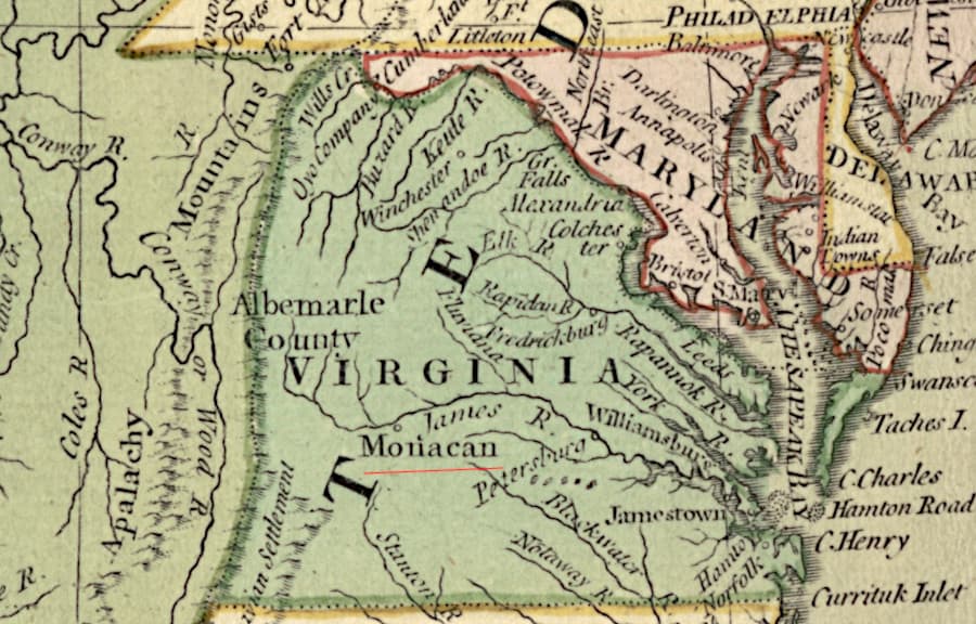
Goochland County’s history runs along the James River, and that river still explains the county’s shape today. Long before the county was authorized in 1727 and formed in 1728, the Monacan people lived in the James River Valley, with Rassawek near the James and Rivanna rivers serving as a major ancestral village and historic capital occupied for more than 4,000 years. That same corridor later drew Huguenot settlers, canal builders, and railroads, leaving a county whose land use, travel patterns, and growth pressures still follow the water, road, and rail lines that cut through it.
Monacan homeland before the county line
The Monacan Nation says its people remain connected to their historic homeland in Virginia, and that connection begins with places such as Rassawek. Outside researchers describe Rassawek as the Monacan historic capital, and the site’s long occupation gives Goochland’s past a depth that predates colonial maps by millennia.
By around 1700, the Monacans had moved westward and Huguenot settlers entered the area, including the village of Manakintown. Goochland County’s own history says the Huguenots settled there as a buffer against possible attacks from Native Americans, a reminder that early settlement was shaped as much by security as by religion or land ownership. The county’s earliest identity was already mixed, with Indigenous, French Protestant, and English colonial influences layered onto the same river landscape.
A frontier county drawn wide
Goochland was authorized by legislation in 1727 and officially formed in 1728, but its first borders reached far beyond the county line known today. The original county stretched from Tuckahoe Creek on both sides of the James River to the Blue Ridge Mountains, making it a frontier unit first and an administrative one second. County historical material describes that early Goochland as a place where large plantations and country estates could take root, and it identifies Tuckahoe Plantation as the oldest recorded river plantation in the county.
That broad footprint did not last. Albemarle County was carved from Goochland’s western side in 1744, and Powhatan County was created south of the river in 1748. Those changes tracked settlement and governance as they moved outward from the James River corridor, showing how quickly the county’s original frontier geography began to subdivide.
River, road, canal, rail
Goochland’s landowners grew tobacco and wheat, but getting those crops to market was difficult because roads were few and often poor. For much of the county’s early life, the James River functioned as the main highway. Another important east-west route was the Three Chopt Road, now generally followed by Route 250, which began as a Native American trail and became part of the county’s travel network.
Transportation improved only after a larger regional vision took shape. George Washington proposed the James River and Kanawha Canal in the 1780s, and the James River Company was incorporated in 1785 with Washington as honorary president. The first seven miles of the James River Canal opened in 1794, and the Great Basin in Richmond opened in 1800, turning the river corridor into a key industrial artery. The U.S. National Park Service describes the canal system as a link between the interior of Virginia and international shipping, which helps explain why the project mattered far beyond Goochland itself.
By 1840, the Kanawha Canal was operating in the county, and Goochland County Economic Development says the county still contains 25% of the total length of the original canal. That is a striking share of a route that once carried much of central Virginia’s commerce. The county’s canal history is not abstract. It is physical, mapped into the landscape in the form of surviving aqueducts, locks, and cuttings.
What survives along the corridor
Goochland’s economic-development materials identify three aqueducts, a lock-keeper’s house, and the only double tunnel culvert on the canal system as surviving relics in the county. Those features show where the old waterway still cuts across the land, even after the canal’s commercial life ended. They also make the county one of the clearest places in Virginia to trace the shift from river transport to engineered infrastructure.
The shift came fast. The Virginia Department of Historic Resources says the Lock-Keeper’s House went out of service when the canal was replaced by the Richmond and Alleghany Railroad, and the railroad tracks were laid on the canal’s towpath. Other county history material says the same corridor was reused by rail by 1880, when the railroad had purchased the right-of-way and put its tracks where mules and horses once pulled packet boats. Chartered in 1878 and operating by 1881, the railroad overtook the canal with remarkable speed, but it did not leave the route behind. It simply occupied it.
That reuse matters because it shows how Goochland’s development has repeatedly concentrated along the same geography. The James River opened the county, the canal organized movement, and the railroad inherited the route. The corridor did not disappear; it changed modes.
Why the old geography still matters
That long run from Monacan homeland to colonial county to canal-and-rail corridor helps explain why Goochland still looks the way it does now. The county’s official profile places it just north of the James River, south of Interstate 64, and between Richmond and Charlottesville in a fast-developing central Virginia corridor. Its rural land remains a major part of its identity, but the same access points that once moved tobacco, wheat, canal boats, and freight now shape commuting, land values, and where housing and business are most likely to concentrate.
The numbers show the pressure. Goochland had 24,727 people in the 2020 census, and the U.S. Census Bureau estimates 29,187 residents as of July 1, 2025. The county also covers 282.1 square miles of land area, making it the 71st largest county in Virginia by total area. That combination of growth and limited land makes transportation corridors especially important, because expansion is not spread evenly across the county. It follows access, and in Goochland access has always meant the James, Route 250, and the routes that tie Richmond to the west.
In Goochland, the past is not a separate chapter from the present. The county’s geography has always decided where people settle, how goods move, and which corridors carry the most value, and that remains true in the county’s next round of growth and land-use choices.
This article was produced by Prism’s automated news system from verified source data, official records, and press releases, then run through automated quality and moderation checks before publishing. The system is built and supervised by the people who set the standards it runs under. Read our full AI policy.
Did this article answer your question?