Traverse City assesses damage after historic April flooding
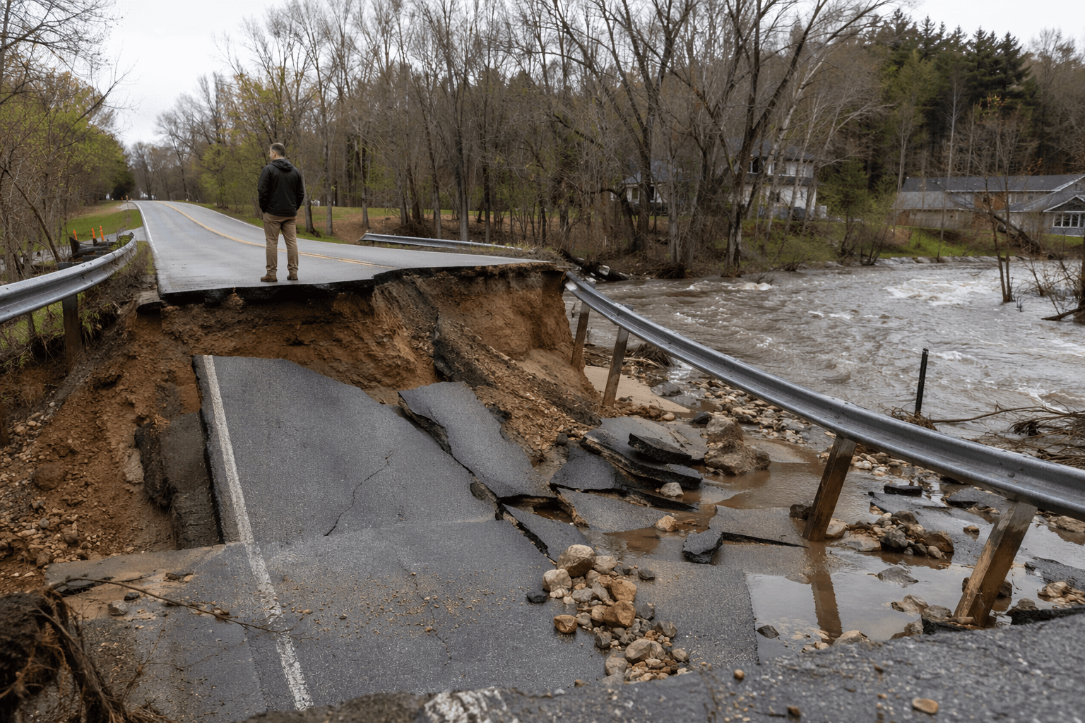
Beitner Road’s collapsed bridge, a closed trail bridge, and sinkholes downtown show April’s flood damage is still not fully contained in Traverse City.

Beitner Road’s collapsed bridge south of Traverse City, a closed pedestrian bridge in the Brown Bridge Quiet Area, and sinkholes and erosion near downtown all show that April’s flooding left behind more than high water. City and county officials are still mapping damage across roads, riverbanks, trails and utility corridors as they try to determine whether Grand Traverse County is any better prepared for the next heavy rain.
The Boardman/Ottaway River system rose with unusual force during the flood. At a U.S. Geological Survey station above Brown Bridge Road near Mayfield, the river reached 1,120 cubic feet per second on April 14, 2026, topping the previous record of 583 cfs set on April 14, 2014 by 92 percent. Near FishPass, water climbed to within half an inch of a 500-year flood threshold, which Traverse City defines as a 0.2 percent chance in any given year.
Grand Traverse County declared a local state of emergency on April 14 and activated its Emergency Operations Center. Officials then held a public briefing on April 15 with the County Road Commission, Traverse City, township leaders, first responders, Traverse City Area Public Schools, Northwest Education Services, Dean Transportation, the Sheriff’s Office, 911/Central Dispatch, Equalization, GIS/Mapping, the Drain Commission, Administration, the Board of Commissioners, Public Health and Emergency Management. Nate Alger said, “Declaring a local state of emergency in Michigan officially authorizes local officials to bypass normal procedures to swiftly respond to disasters.”
The flood damaged roads, drainage systems, riverbanks and trails. The city closed Lot A north of the 100 block of East Front Street after a sinkhole opened there, and it shut portions of Lot K because of riverbank erosion. The Grasshopper Creek pedestrian bridge at trail marker 5 in the Brown Bridge Quiet Area remains closed, and city officials are warning people to use extreme caution on trails. Water also overtopped areas near South Airport Road and Logan’s Landing.
Officials say earlier infrastructure work prevented a worse environmental disaster. In 2023, Traverse City completed the sanitary sewer relocation in the 100 block of East Front Street and river wall stabilization in the 200 block along the Boardman/Ottaway corridor. During the flood, a sinkhole exposed an abandoned 24-inch sewer line with a compromised service connection, but the newer 30-inch main in the alley kept a major discharge from reaching the river. The city estimates that without that work, about 1.5 million gallons per day of raw sewage could have flowed into the Boardman/Ottaway River and eventually Grand Traverse Bay.
By May 21, county officials were estimating flood damage at $21.2 million, according to Gregg Bird. The county is working with state and federal officials on damage review and FEMA disaster funding, while Gov. Gretchen Whitmer expanded Michigan’s state of emergency to include Grand Traverse County and 32 other counties. Residents are still being asked to report home, property and roadway damage so officials can measure what remains vulnerable before the next storm.
This article was produced by Prism’s automated news system from verified source data, official records, and press releases, then run through automated quality and moderation checks before publishing. The system is built and supervised by the people who set the standards it runs under. Read our full AI policy.
Did this article answer your question?