National Hurricane Center Revamps Cone of Uncertainty for 2026 Season
The NHC's cone of uncertainty gets its biggest redesign in over 20 years: wider ellipses replace circles and the confidence threshold jumps from 67% to 90%.

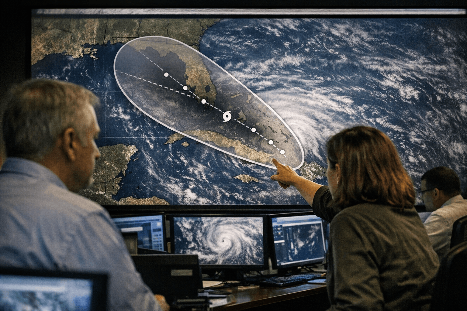
The National Hurricane Center's familiar cone of uncertainty is getting its biggest conceptual overhaul in more than two decades, with a redesigned experimental graphic set to debut for the 2026 Atlantic season that replaces circular geometry with directionally aware ellipses and raises the statistical confidence standard from 67 to 90 percent.
The practical result: the new cone will be roughly 23 percent wider than the version Gulf Coast communities have relied on since the NHC introduced the graphic in 2002. That added width reflects a deliberate methodological shift. The current cone draws circles of equal radius around each forecast track point, implying a storm center is equally likely to stray in any direction. The new design uses ellipses calibrated to two distinct types of historical error: along-track errors, which measure how far a storm center ends up ahead of or behind the NHC forecast, and cross-track errors, which measure how far the center deviates left or right of the predicted path.
By switching to ellipses sized at the 90th percentile of those combined errors, the NHC is signaling that the shaded cone will contain the storm's actual center nine times out of ten, compared to roughly two-thirds of the time under the previous standard. Michael Brennan, director of NOAA's National Hurricane Center, said the suite of 2026 changes aims to help communities prepare "earlier and more effectively" for hazards from tropical storms and hurricanes. The experimental ellipse cone will appear on the agency's public forecast page shortly after each advisory during the season, running alongside the operational cone as NOAA evaluates performance and public comprehension.
For Harris County, the distinction matters immediately. Emergency managers, storm surge modelers and hospital evacuation planners in the Houston region have spent years pushing back against a persistent public misconception: that sitting outside the cone means sitting outside danger. The NHC has been consistent on this point since the original 2002 rollout and a 2007 revision. The cone depicts only the probable envelope for a storm's center, not the full extent of hazardous conditions. Wind fields, rainfall, storm surge and tornadoes routinely extend well beyond the shaded area, a lesson that coastal and inland Harris County neighborhoods relearn with each significant storm.
The 2026 redesign makes the cone more statistically accurate, but it does not resolve the underlying communication challenge. A wider graphic, one that now absorbs a broader range of directional uncertainty, makes it harder to rationalize that any single zip code is safely outside the threat. That is a feature, not a flaw, but local officials will still need to ensure residents do not simply treat the outer edge of the larger ellipse as a new safety boundary.
The operational standard cone for 2026 also incorporates a separate, now fully approved change that completed its own experimental phase during the 2024 and 2025 seasons: the graphic will display inland tropical storm and hurricane watches and warnings, replacing a version that showed only coastal alerts. For a county that stretches roughly 50 miles from Galveston Bay into suburban and semi-rural terrain, that inland visibility is significant.
Both the experimental ellipse cone and the updated operational graphic are expected to be active when the Atlantic season formally opens June 1.
Sources:
Know something we missed? Have a correction or additional information?
Submit a Tip