Hernando County updates disaster plan to reduce future flood risk
Hernando County’s 2025 mitigation update puts flood risk front and center for Brooksville, Spring Hill and Hernando Beach. The plan could steer drainage fixes, maps and homeowner decisions.
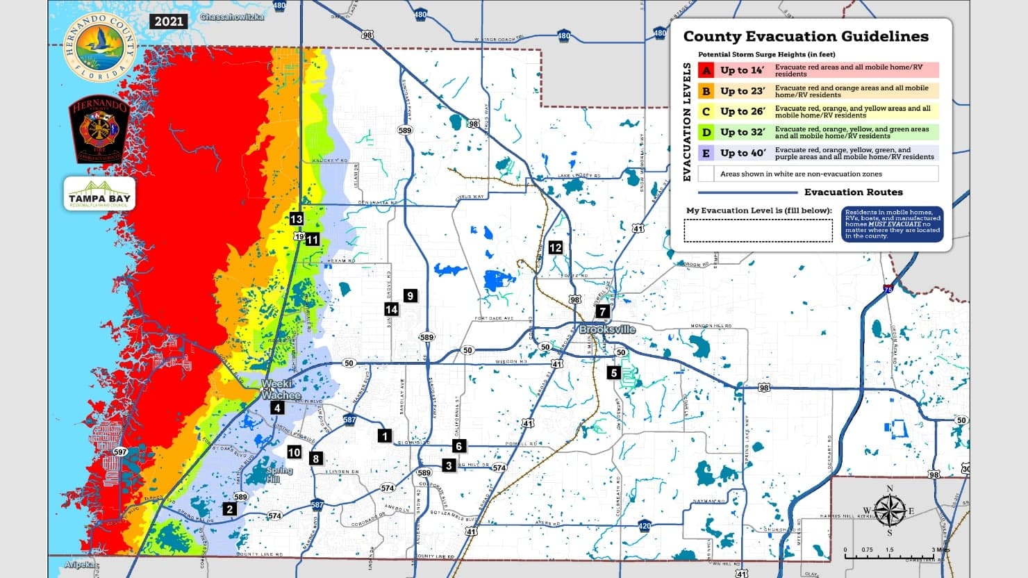
The county’s flood-awareness brochure calls floods the most common natural disaster in Hernando County, and the 2025 Local Mitigation Strategy puts flood reduction at the center of long-range disaster planning. The county identifies itself as vulnerable to large-scale hazards and wants to cut the human, economic and environmental costs before the next emergency hits. The update was built by the Hernando County Local Mitigation Strategy Working Group with the Tampa Bay Regional Planning Council, extending the work beyond one office and into the broader Tampa Bay region.
Why flood risk drives the update
FEMA’s hazard mitigation planning framework focuses on reducing long-term risk from hazards, and Florida Disaster places local mitigation strategies inside Florida’s mitigation framework. Hurricanes, tropical storms and slow-moving winter fronts can all trigger serious flooding in both inland and coastal communities, which makes the county’s mitigation work as much about everyday drainage and land use as it is about storm response.
The 2025 update is built around prevention rather than cleanup. Its abstract calls for a plan that lessens the human, economic and environmental costs of disasters, which is a different goal than simply organizing sandbags and shelter space when a storm is already on the radar. In practice, that means the strategy is supposed to help local officials think ahead about where the next flood losses are most likely to land.
Where the county’s risk shows up
Brooksville, Spring Hill and Hernando Beach give the strategy three different settings to cover at once: an inland county center, a fast-growing suburban area and a coastal community. Flood risk does not look the same everywhere, and the county’s planning has to account for inland neighborhoods, coastal communities, low-lying areas and the roads that connect them.
The same weather system can hit very different places in very different ways. A hurricane can push water into coastal areas, a tropical storm can saturate drainage systems across suburban neighborhoods, and a slow-moving winter front can still leave neighborhoods dealing with water that has nowhere to go.
What the strategy can change on the ground
Mitigation is the part of disaster management that tries to stop losses before they happen. In practical terms, that means the 2025 strategy can shape which drainage fixes rise to the top, how public facilities are hardened, which critical infrastructure gets extra attention and how land use is weighed against known hazards. These plans also help determine what kinds of grant applications get prepared and how local government thinks about long-term resilience.
The cost of inaction is not limited to a flooded street after one heavy storm. A countywide mitigation plan can influence which neighborhoods get attention first, which public assets are considered most vulnerable and how future spending is justified when local leaders compete for limited dollars. In a growing county, the strategy becomes part of the argument over what gets protected, repaired or redesigned before the next disaster arrives.
How maps affect property owners and builders
Hernando County’s flood materials point residents, business owners, local officials, engineers and builders to Flood Insurance Rate Maps, or FIRMs, as important tools in flood-prone areas. Those maps help the people making decisions about homes, businesses, roads and drainage systems understand where flood risk needs to be built into the process from the start. For anyone buying property, planning a project or maintaining a building, the maps are one of the county’s clearest signals that flood planning is not just for emergency season.
Even if a resident never attends a county planning meeting, the way Hernando County uses flood maps can shape what gets built, where it gets built and how safely it performs during the kind of weather the county says hits most often. The county’s approach links property decisions to public safety, and it does so before the first warning is ever issued.
What residents are told to do now
In the county’s 2025 All-Hazards Disaster Planning Guide, hurricane season runs from June 1 through November 30, and its preparedness materials treat readiness as a shared responsibility across households, businesses, faith-based groups, volunteer and civic groups, schools and government. Disaster planning does not live only inside emergency management.
The county organizes that responsibility into four basics:
- Make a plan.
- Build a kit.
- Stay informed.
- Get involved.
This article was produced by Prism’s automated news system from verified source data, official records, and press releases, then run through automated quality and moderation checks before publishing. The system is built and supervised by the people who set the standards it runs under. Read our full AI policy.
Did this article answer your question?