Weeki Wachee protection zone allows swimming, bans vessel anchoring
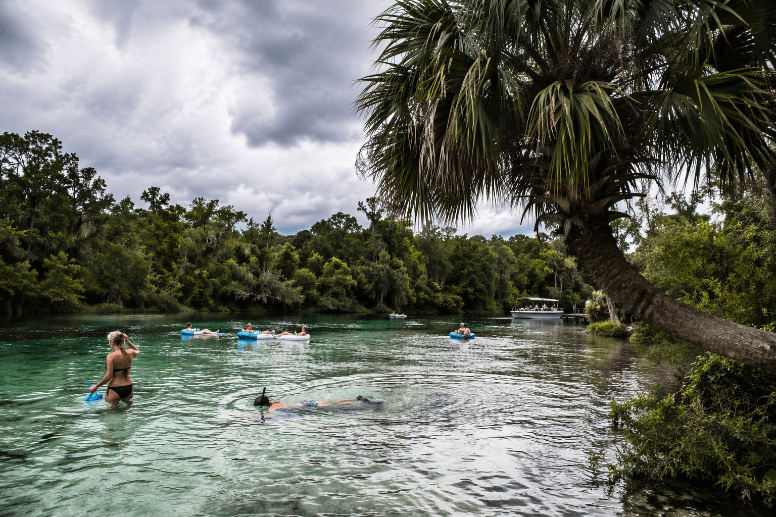
You can still swim, snorkel and tube the Weeki Wachee River, but anchoring or beaching a vessel inside the 5.61-mile protection zone brings a $140 fine.
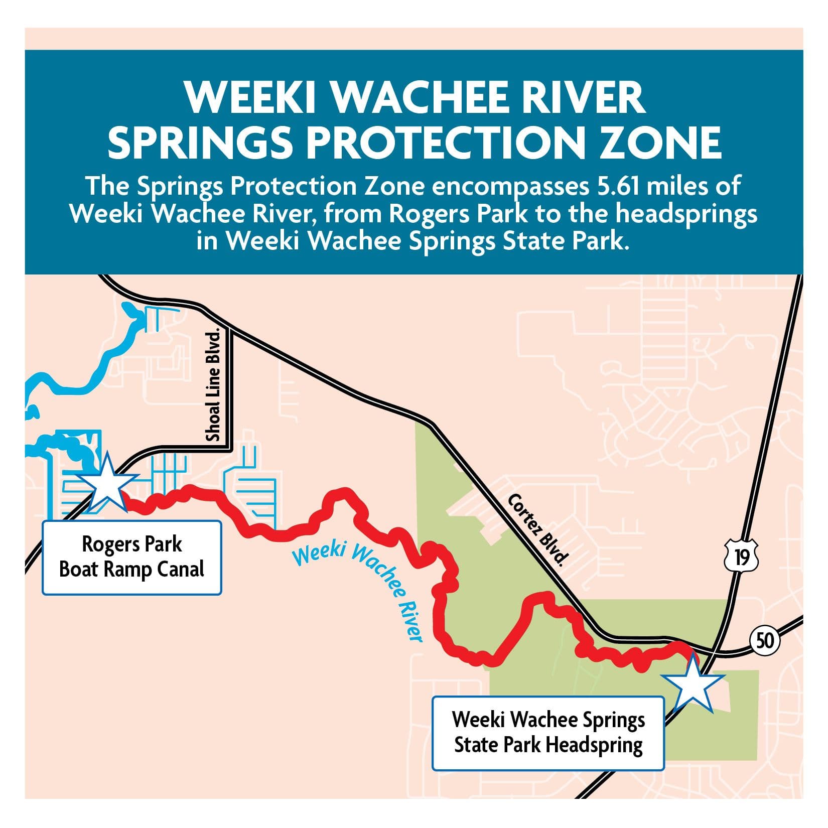
A day on the Weeki Wachee River still includes swimming, snorkeling and floating, but it now comes with a hard boundary: no anchoring, mooring, beaching or grounding a vessel inside the 5.61-mile protection zone. The protected stretch runs from the Rogers Park Boat Ramp canal to the headsprings inside Weeki Wachee Springs State Park, and a violation carries a $140 fine. For anyone launching at Rogers Park or drifting through the spring run, the rule is meant to keep boats from damaging the waterway, not to close the river.
What the rule means on the river
The biggest practical change is simple: if you are operating a vessel, you cannot stop and tie up or run aground inside the protected stretch. The zone is written to protect the river’s ecology, not to shut out public use, and it explicitly allows swimming, snorkeling and floating on a raft or tube. That makes the rule easy to describe and still easy to misunderstand, especially on a busy spring run where people are moving, pausing and entering the water in different ways.
The distinction between a swimmer and a vessel operator matters here. Most tubes and rafts are not considered vessels under Florida law, with limited exceptions, which is one reason visitors can still float through the area while boaters face the anchoring ban. That legal line is where confusion tends to start, especially for people arriving from outside Hernando County who know Weeki Wachee Springs mostly as a recreation spot and not as a regulated spring corridor.
Where the 5.61-mile zone begins and ends
The Weeki Wachee Springs Protection Zone is 5.61 miles long. The protected stretch starts where the Hernando County Rogers Park boat ramp canal meets the spring run and continues upstream to the farthest point of the main spring boil inside Weeki Wachee Springs State Park. The downstream point is Latitude 28°31′54.3″N, Longitude 82°37′35.1″W, and the upstream point is Latitude 28°31′1.9″N, Longitude 82°34′24.4″W.
The zone is not a vague no-go area scattered around the river. It is a defined corridor tied to fixed endpoints, with Rogers Park serving as the most visible local reference point for boaters. If you launch there, or pass through that reach on a tube or paddlecraft, the safest habit is to know whether your activity involves a vessel and to keep that vessel moving rather than stopping inside the protected stretch.
Why county and state officials created it
The Florida Fish and Wildlife Conservation Commission first presented the proposed rule at its May 2023 commission meeting and approved the final rule at its July 19, 2023 meeting. Hernando County requested the protection zone, and commission materials set its purpose as protecting natural vegetation and wildlife along the spring run. The rule is also intended to protect water quality, water quantity, hydrology, wetlands and habitat.
FWC staff conducted site visits and found evidence of harm from vessel activity along the spring run, which helped drive the push for a protection zone. In practice, the zone reflects a collaboration between local county officials and state regulators, with the Hernando County Board of County Commissioners asking for a response to impacts that were already visible along the river.
How the rule fits into county waterway management
The protection zone is part of a wider management system already in place along Hernando County waterways. The county’s Waterways Division handles aids to navigation, docks and piers, boat ramps and kayak launches, navigation lights and buoys, aquatic plant harvesting, and marine habitat enhancement and restoration.
The protection zone protects a segment of the spring run while leaving room for recreation that does not depend on vessel anchoring. It also gives county crews and visitors a clearer framework for how the river should be used, especially at launch points, along bank edges and in the narrow places where people are most likely to drift too close to vegetation.
What to do to avoid trouble in the zone
The simplest way to stay clear of a citation is to treat the protected stretch as a no-anchoring corridor. Keep vessels moving through the zone, do not beach on the banks, and do not ground or moor within the restricted area. If your plan includes time in the water, the county’s rules still allow swimming, snorkeling and floating on a raft or tube, but they do not give vessel operators the same freedom to stop and set up inside the protected run.
A practical visit to Weeki Wachee now starts with the same basic checklist every time: know where Rogers Park sits, remember that the protected stretch runs upstream to Weeki Wachee Springs State Park, and stay off the vegetation, banks and trees that line the spring run.
This article was produced by Prism’s automated news system from verified source data, official records, and press releases, then run through automated quality and moderation checks before publishing. The system is built and supervised by the people who set the standards it runs under. Read our full AI policy.
Know something we missed? Have a correction or additional information?
Submit a Tip