Holmes County map guide explains tricky rural addresses and routes
Holmes County’s roads can send GPS to the wrong place, delaying appointments and deliveries. Knowing SR, CR and TR labels, town names and byway routes keeps trips on track.
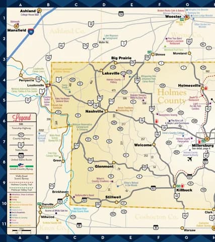
The 2021 Visit Amish Country map guide gave a simple fix for Holmes County searches: write route abbreviations as SR for State Route, CR for County Road and TR for Township Road.
In Holmes County, route labels, mailing addresses and the roads people actually drive do not always line up. Holes in a route can mean missed school events, late medical appointments, delivery failures and even confusion for emergency crews.
If you are heading to a clinic, a shop, a market or a home off a township road, the difference between a Millersburg address and a Berlin location can decide whether you arrive on time or circle back after dark.
How to enter roads so the map app has a chance
The abbreviations that matter
That small change can make a search more reliable because some map programs understand those labels better when they are spelled out.
Some GPS units still will not recognize those abbreviations. Use Highway instead of Road when a search keeps missing the mark. That advice is especially useful in a county where a road name may be familiar to locals but not to a navigation app.
Why the warning is so blunt
Visit Amish Country’s “Getting Around” page puts it plainly: “Navigating our area might seem tricky. With a little guidance and caution, you’ll have no problem finding your way around this rural community.” Holmes County works on the ground as a rural community of small settlements linked by county roads, township roads and state routes rather than a single dense grid.
The result is a place where an address can look straightforward on paper and still mislead the driver. A business with a Millersburg mailing address may actually sit in Berlin, and a Sugarcreek address may be closer to Walnut Creek. That matters when a package is out for delivery, when a ride-share is trying to pin down a driveway, or when a family is trying to beat the clock to an appointment.
Where to start when an address does not match the building
Holmes County has three key information centers for visitors and residents, and the primary one is the Holmes County Chamber of Commerce & Tourism Bureau at 6 W. Jackson St., Millersburg, OH 44654. That location can serve as a backup starting point when a map app, a package label or a directory listing points you in the wrong direction.
Ohio Amish Country is a place of country roads winding through a patchwork of farms and small towns. Local navigation feels different from a city map because the roads are the system, and the settlements are spread across it. A “wander map” helps travelers find local businesses and attractions when the next turn is on a lane rather than a boulevard.
A new visitor center grand opening was planned for Sept. 24, 2025 at the chamber’s newly remodeled offices and welcome center.
The county’s roads are the story
Holmes County’s road network has long been organized around more than just the town centers people recognize by name. An Ohio Department of Transportation update to the Amish Country Byway Corridor Management Plan in June 2019 formalized the byway as a managed scenic corridor, not just a stretch of pavement. Travelers are often following a regional route pattern rather than a simple from-A-to-B shortcut.
U.S. Route 62 bisects Holmes County from southwest to northeast and passes through Millersburg. That gives travelers a major spine to orient around before they peel off onto county roads, township roads or village streets. If you know where U.S. 62 runs, the rest of the map starts to make more sense.
Older county maps show how deeply road-based navigation has shaped the area for decades. A 1970 Holmes County highway map listed the total lengths of county roads, township roads, state roads and total mileage. A 1983 county highway map covered Glenmont, Holmesville and Killbuck, and identified county highways, township roads and city streets.
A practical way to move around Holmes County
Before you head out, check how the road is labeled, where the mailing address points, and whether the destination is closer to a nearby village than the town named on the envelope.
- Spell out SR, CR and TR in your search field.
- If the GPS stalls, try Highway instead of Road.
- Compare the mailing address with the actual nearby village, especially around Millersburg, Berlin, Sugarcreek and Walnut Creek.
- Use the Holmes County Chamber of Commerce & Tourism Bureau at 6 W. Jackson St. as a backup starting point.
- Look for the wander map and check route information before you leave.
This article was produced by Prism’s automated news system from verified source data, official records, and press releases, then run through automated quality and moderation checks before publishing. The system is built and supervised by the people who set the standards it runs under. Read our full AI policy.
Did this article answer your question?