Holmes County Trail offers scenic ride, buggy lane and easy access
Holmes County Trail gives riders a paved, easy route with a rare Amish buggy lane, plus practical access from Millersburg, Fredericksburg and Killbuck.

The 15.7-mile Holmes County Trail includes a separate buggy lane, so bicycles, walkers and Amish buggies can share the corridor. AllTrails lists about 282 feet of elevation gain, and the route stands out in Ohio because it was built for the way Holmes County actually moves.
A trail shaped by county life
The Holmes County Trail is part of the 326-mile Ohio to Erie Trail, but its Holmes County section has its own identity. It is the only trail designed to accommodate Amish buggies, which makes it as much transportation infrastructure as recreation path. It is a paved corridor through Ohio’s Amish Country where non-motorized traffic fits into the county’s daily rhythm.
The Holmes County portion is a wide paved route with bikes and buggies using different sides of the trail, and that visible separation is what most visitors notice first. Rather than a generic park path, you are riding through a working landscape where farms, small towns and buggy traffic are part of the view.
Where to start, and which stretch works best
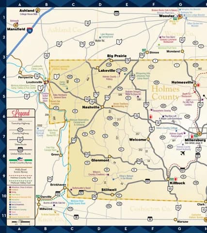
If you want the simplest planning option, Millersburg sits near the midpoint of the trail and gives you a practical central base. Fifteen miles are completed between Fredericksburg and Killbuck, so that stretch is the cleanest choice for a long, mostly straightforward ride. The Holmes County Trail maps also show the Glenmont to Brinkhaven section, which was paved and opened in 2017, giving riders another defined segment to build a route around.
For families and first-time riders, the trail’s easy rating keeps the ride approachable even if you do not want a full-day workout. The completed Fredericksburg-to-Killbuck stretch is the most obvious place to start when you want a paved ride with minimal climbing and a clear sense of the route.
A simple way to think about the trail is by purpose:
- Fredericksburg to Killbuck works well for a longer out-and-back on the main completed section
- Millersburg is the best central access point if you want flexibility and a shorter ride
- Glenmont to Brinkhaven gives you the paved segment opened in 2017
- Killbuck is useful if you want to enter near the western end and keep the outing compact
Parking and access points that actually help
It is worth knowing where the lots and entry points are before you arrive. There is a small parking area in Glenmont at the southern end of the newer section, and parking at the old Killbuck train station. For the Millersburg-to-Holmesville stretch, turn onto the access road behind the Route 83 Restaurant on the west side of OH-83 and proceed to the trail parking lot.
Millersburg South access has parking in a Walmart lot, which is useful when you want a straightforward stop close to town. The official Holmes County Trail site and the Holmes County Park District have trail rules, trail maps, photos and contact information, so checking those pages before heading out remains the best way to match your route to the access point you plan to use.
What the ride feels like on the ground
The trail passes woodland, swamps and open farmland along the way, which gives the route a strong sense of place and keeps the county’s rural character visible the whole time.
Because the trail is designed for mixed non-motorized use, pace matters more here than on a typical bike path. The buggy lane is the key feature: this is a shared corridor built around local traffic patterns, not a closed recreational loop.
Town stops, food stops and the county view
Millersburg gives the trail its most useful anchor point, but Fredericksburg, Killbuck, Glenmont and Brinkhaven help turn the ride into a county-to-county day rather than a simple out-and-back. The trail functions as a recreation and transportation corridor through scenic Holmes County when you connect it to nearby towns. A ride can include a quiet stretch of pavement, a town stop, and another segment of trail.
That town connection also puts food and errands within reach. Millersburg Coffee Company and Hershberger’s Farm and Bakery are among the stops around the trail and Millersburg after a few miles on the trail. When you pair those stops with the trail’s midpoint access in Millersburg, the route becomes a practical half-day or full-day outing.
This article was produced by Prism’s automated news system from verified source data, official records, and press releases, then run through automated quality and moderation checks before publishing. The system is built and supervised by the people who set the standards it runs under. Read our full AI policy.
Did this article answer your question?