Lake Ottawa offers hiking, history and year-round Northwoods access
Lake Ottawa gives Iron County one place for summer hiking, winter skiing and lake access. Its CCC-era buildings and Ge-Che Trail link make it a true local basecamp.
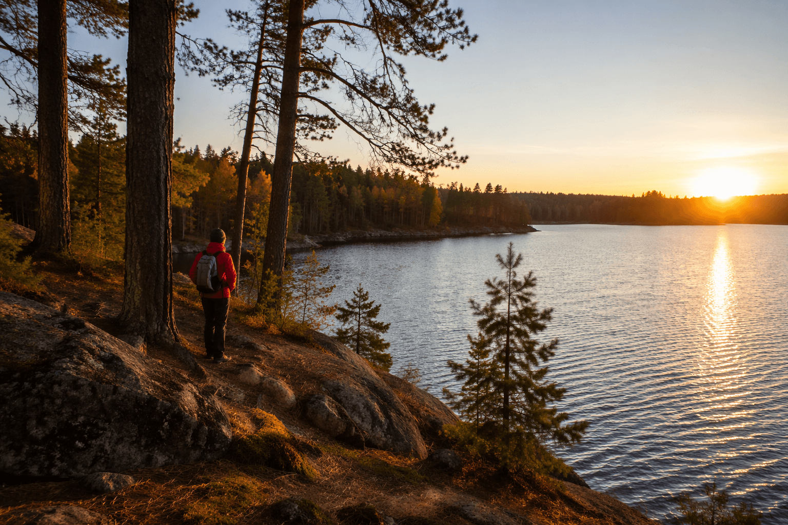
Lake Ottawa is Iron County’s rare all-in-one trailhead, a CCC-built campground and day-use hub just 5 miles southwest of Iron River where a boat launch, fishing access and the Ge-Che Trail all meet in one forested corridor. For county residents, that means one familiar spot can serve a family picnic in July, a hike in October and a ski outing in January without leaving the Northwoods.
A local basecamp, not just a campground
The Forest Service places Lake Ottawa Recreation Area on the Iron River Ranger District, surrounded by a dense Northwoods setting and a cluster of familiar names that define this corner of Iron County: Lake Ottawa, Brule Lake, Hagerman Lake, Brule River, Bass Lake, the Historic Mile Post Zero/Treaty Tree and miles of hiking trails. The campground itself sits 95% surrounded by National Forest System lands, which helps explain why it feels so enclosed by woods even though it is close to town. That proximity matters locally, because it puts a multi-use forest site within easy reach of Iron River rather than making residents drive deep into the backcountry for a day outside.
The setup is practical as well as scenic. Lake Ottawa has 32 campsites, paved access roads, a pressurized water system, flush toilets and a trailer dump station, along with a pavilion, original log picnic tables and log toilet buildings. The developed camping limit is 14 days, which keeps the site in regular rotation for family trips, seasonal visitors and weekend users who depend on a predictable, well-kept public campground close to home.
What summer brings
In warm weather, Lake Ottawa works the way a county recreation site should: as a place to launch a boat, fish from shore or spend a full day around the water without needing a separate itinerary. The fishing options named for the lake include lake trout, bass, walleye and panfish, with access for shore fishing, motorized boats, float tubes, fly, spin, bait and even ice fishing when conditions allow. The Forest Service also says passenger cars can reach the site, which makes it a realistic day trip for families and not just a destination for people towing gear or arriving with specialized equipment.
That same day-use area gives the site a broader public value than a standard campground. The area next to the campground includes picnic space and a boat launch, and the Forest Service notes a CCC-era day-use recreation building nearby, even though that building is listed as closed pending repairs on the agency page. For Iron County residents, the point is less about one single amenity and more about the combination: water access, picnic facilities, a trailhead and a campground in one place, all on a road that comes in directly from the Iron River area.
The Ge-Che Trail is what makes the place different
Lake Ottawa stands out because it is not only a campsite on a lake. It is also one of the main access points for the Ge-Che Hiking Trail, a roughly nine-mile dirt trail that runs mostly through hardwood forest and stays moderate to strenuous with hills and some flatter stretches. The Forest Service says the trail has almost no broad vistas, except for a ridge-line segment near Ottawa Lake, so this is a woods-first hike rather than a scenic overlook route. That distinction matters for local use: the trail rewards people who want a solid half-day walk or ski, not a quick overlook stop.
Just as important, the trail changes with the season. In winter, the Ge-Che Trail is used as a cross-country ski route, and it can be accessed from both the Lake Ottawa campground and the boat landing. That makes Lake Ottawa a year-round trailhead rather than a site that closes down conceptually when camping season ends. Families can use the same corridor for different kinds of outings all year, while hikers and skiers get a route that is already tied to a familiar road network and established facilities.
The CCC history is still visible on the ground
Lake Ottawa is one of the clearest places in Iron County to see how New Deal-era conservation work still shapes public recreation. The pavilion, original log picnic tables and log toilet buildings were built by the Civilian Conservation Corps in the late 1930s, and those same structures remain part of the visitor experience today. That matters because the site is not just a preserved story on a sign; it is a working recreation area where CCC craftsmanship still supports current use.
The CCC connection also ties Lake Ottawa to the broader public history of the Northwoods, where federal work crews left behind rustic infrastructure that still serves hunters, anglers, campers and hikers. At Lake Ottawa, that legacy is not separated from daily use. It is the setting itself, with the log buildings, stone fireplaces and campground layout doing the same job they were built to do decades ago.
What to know before you go
If you are planning a trip, the most useful habit is also the simplest: bring a map and check route designations before you leave home. The Forest Service directs hikers, horseback riders and mountain bikers to consult trail maps, visitor maps and motor vehicle use maps, because not every road or trail in the Ottawa National Forest is open to every user. For motorized travel, routes not shown on the Motor Vehicle Use Map are not open to public motor vehicle use, and those maps are reissued to reflect current travel decisions.
That caution is especially important for winter users. The Ottawa’s winter rules say Motor Vehicle Use Maps do not govern snowmobile use, snowmobiling is limited to designated trails in certain areas, and riders must carry current state registration and a Michigan snowmobile trail sticker. Lake Ottawa itself is best understood as a ski and hiking hub, but anyone connecting into the broader forest trail system should check the current travel rules before heading out so the day starts on the right side of the map.
For Iron County, Lake Ottawa’s value is obvious: one public site near Iron River that handles camping, fishing, hiking, winter skiing and day-use traffic without asking residents to treat each activity as a separate destination. Its local strength is exactly that it serves the county first. The history is visible, the access is practical and the trail system keeps it relevant in every season.
This article was produced by Prism’s automated news system from verified source data, official records, and press releases, then run through automated quality and moderation checks before publishing. The system is built and supervised by the people who set the standards it runs under. Read our full AI policy.
Did this article answer your question?