Photographer Captures Dramatic Crashing Surf at Deception Pass State Park
North Whidbey photographer Pam Headridge caught fearless beachgoers inches from crashing waves at Deception Pass State Park.

Walls of white water exploding against the rocky shoreline at Deception Pass State Park drew both a camera and a crowd last week, when North Whidbey photographer Pam Headridge turned a late-season swell into a striking visual record of one of the Pacific Northwest's most dynamic coastal landscapes.
Headridge captured images of adventurous visitors at Deception Pass as waves crashed nearby, producing a photograph series and short visual feature that published March 20. The images show the raw power that makes Deception Pass such a compulsive destination for anyone who has walked its shores during a storm.
Deception Pass State Park draws over two million visitors annually, making it one of Washington's most attended state parks. It is a dramatic seascape where the tidal flow and whirlpools beneath the twin bridges connecting Fidalgo Island to Whidbey Island move quickly. During ebb and flood tide, current speed reaches about 8 knots, flowing in opposite directions between ebb and flood.
The pass is the waterway between Whidbey and Fidalgo Islands, where the tidal flow between Skagit Bay and the Strait of Juan de Fuca moves quickly, making the passage dangerous for watercraft. During low tides, the swift current can lead to standing waves, large whirlpools, and roiling eddies, visible from the twin bridges' pedestrian walkways or from the trail below the larger south bridge on the Whidbey Island side.
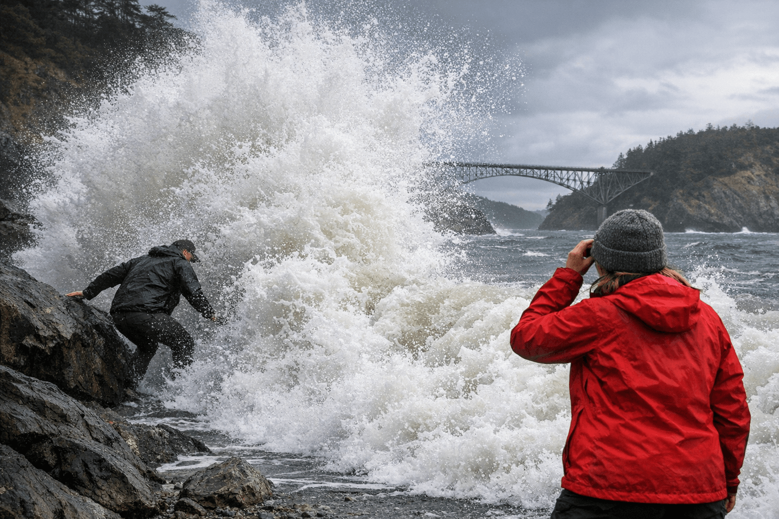
The timing of Headridge's shoot coincided with blustery late-winter conditions along the north island. The National Weather Service issued a wind advisory for the Deception Pass area on March 23. Those conditions, familiar to anyone who lives in Island County through the winter and early spring, are precisely what transform Deception Pass from a scenic overlook into something more primal.
The park was established in 1923, when the original 1,600 acres of a military reserve were transferred to Washington State Parks, with facilities later improved in the 1930s by the Civilian Conservation Corps, which built roads, trails, and buildings. More than a century on, its rocky bluffs and churning narrows remain one of the most photographed stretches of coastline in the state, and Headridge's images are a reminder of why.
This article was produced by Prism’s automated news system from verified source data, official records, and press releases, then run through automated quality and moderation checks before publishing. The system is built and supervised by the people who set the standards it runs under. Read our full AI policy.
Did this article answer your question?