Alice International Airport serves military training, tourism and local aviation
Alice International Airport is Jim Wells County’s only public-use airfield, and its value runs through Navy training, hunting traffic, and the skilled work needed to keep it open.
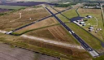
Alice International Airport sits about three miles southeast of Alice and serves as Jim Wells County’s only public-use airport. With two asphalt runways, it handles far more than casual local flying: it supports military practice, seasonal tourism, emergency aviation, and the day-to-day general aviation that keeps the county connected.
The airport is jointly owned by the City of Alice and Jim Wells County, which makes it a shared public asset rather than a private strip. It carries the FAA identifier ALI and the ICAO code KALI, covers 556 acres, and sits at an elevation of about 178 feet above sea level. Those details matter because they show a facility built to function as regional infrastructure, not just a convenience for a few pilots.
What the airfield looks like on the ground
The airport has two runways: 13/31 measures 5,997 feet by 100 feet, and 17/35 measures 4,490 feet by 100 feet. Both are asphalt, and both are equipped for active use. Runway 13/31 includes lighting and visual aids, while runway 17/35 also has lighting, giving pilots flexibility in how they approach the field.
The airport information page lists the kinds of details that matter to pilots and operators: a medium-intensity runway lighting system set to low intensity from dusk until 11 p.m., with brighter activation available after 11 p.m. It also notes a MALS on runway 31, REILs on runway 13, and PAPI on runways 17 and 35. For a county airport, that is a substantial set of operational tools, the kind of setup that supports regular traffic and training work rather than occasional takeoffs alone.
Why Navy training is a central use
The city says Alice International Airport serves U.S. Navy pilots for touch-and-go exercises, and recent local reporting puts that role at the center of airport activity. About 65 percent of the airport’s traffic comes from Navy practice flights between Alice and the Orange Grove landing field, a share that makes military training the airport’s most visible function.
That training traffic has practical implications for Jim Wells County. It keeps the field active, supports a repeatable cycle of aviation operations, and links a local public asset to a continuing military need. For a rural county, that kind of usage means the airport is part of the broader training pipeline, with aircraft, fuel, maintenance, and field operations all moving through one place on a regular basis.
A seasonal tourism asset tied to hunting ranch traffic
The airport’s other major role comes from South Texas hunting traffic. The city describes Alice International Airport as a regional tourism asset for hunting ranch visitors, and local reporting says private planes and jets pick up during hunting season. That seasonal pattern matters because it shows the airport serving an economic cycle that is familiar across South Texas: visitors arrive, local services are used, and the airport becomes part of the regional outdoor economy.
This is where the airport’s place in the county seat starts to matter beyond aviation. Alice has long been shaped by railroad-junction roots, cattle ranching, and oil and gas activity, and the airport now fits into that same practical identity. It does not replace those sectors; it adds another access point for business, recreation, and travel.
The services that make it usable
The airport’s value depends on more than pavement. The city lists full-service AV gas and Jet A, self-serve AV gas, hangar space on request, tie-down space, oxygen, 24/7 callout service on request, pilot supplies, a courtesy van, and an FBO lounge with a flight-planning and briefing room, complimentary coffee and snacks, guest Wi-Fi, showers, and an outdoor patio.
Those amenities matter because they make the field functional for visiting pilots, training aircraft, and transient traffic. Fuel, shelter, planning space, and ground transportation are the quiet infrastructure that keeps an airport moving. Without them, the runways would be much less useful to the people who actually land there.

The public cost and the workforce behind the runway
Recent local reporting said the airport operates on an annual budget of about $300,000, with roughly $1.5 million a year in capital needs and about $100,000 annually from the state’s routine airport maintenance program. It is staffed by one full-time maintenance worker and a part-time airport manager.
Those numbers show how leanly the airport is run compared with its responsibilities. The staffing profile also points to the kind of local jobs the airport creates: maintenance, operations, fueling, scheduling, and oversight. It is a small workforce, but it is a specialized one, and that is exactly why the airport matters as a skills pipeline. Aviation work is technical, and the airport gives Jim Wells County a place where that technical labor is needed every day.
Emergency and public-safety value
The airport also serves as a staging point when conditions turn dangerous. The Texas A&M Forest Service uses the airport to stage firefighting aircraft during periods of high fire danger, giving the field a role in emergency response that goes well beyond tourism or training. That use is easy to overlook until wildfire risk rises, and then a functioning runway becomes a critical asset.
That emergency function also strengthens the argument for maintaining the airport as a countywide resource. A field that can support Navy practice flights, tourism traffic, and fire aircraft offers a level of flexibility that few rural facilities can match. In practical terms, that means the airport is part of the county’s resilience.
A field with wartime origins and a longer aviation history
Alice International Airport was activated in February 1943, placing its beginnings in the wartime era. It also had a brief commercial passenger chapter when Trans-Texas Airways operated Douglas DC-3 service from Alice from 1950 to 1951. That history explains why the airport has long been more than a simple local landing strip.
The commercial service did not last, but the airport did. Over time it settled into the role it now plays: a county-owned public-use airport serving military training, seasonal visitors, and local aviation needs. The continuity is the point. The runways that began as wartime infrastructure still support a working airport today.
Why it matters for Jim Wells County
Alice International Airport is not a boosterish symbol. It is a working facility with clear uses, limited staff, real capital needs, and measurable traffic. It handles Navy touch-and-go flights, supports hunting-season arrivals, gives the Texas A&M Forest Service a staging site, and offers the fuel and ground services that keep aircraft moving.
For Jim Wells County, the strongest case for the airport is not image. It is utility. The airport connects military training, emergency access, and aviation jobs to a public asset that remains active, shared, and useful every day.
This article was produced by Prism’s automated news system from verified source data, official records, and press releases, then run through automated quality and moderation checks before publishing. The system is built and supervised by the people who set the standards it runs under. Read our full AI policy.
Did this article answer your question?


