Waimea Canyon and Kokee draw visitors with views, trails, history
Waimea Canyon and Kōkee offer more than lookouts: from a 0.3-mile loop to a 3.1-mile ridge hike, the right choice depends on heat, mud, and climbing.
Waimea Canyon Lookout can be a quick rim stop, but the same park system also holds short loops, cool forest days and serious ridge hikes. Visitors have been coming to Kauai’s uplands for more than 100 years.
A landscape with a long public life
Waimea Canyon was designated as Waimea Canyon State Park in 1937, and Waimea Canyon and Kōkee were later established as public parks in 1952, putting them among the oldest parks in the Hawaii state park system. Both parks were once part of forest reserves, then withdrawn in 1919 and 1922 for recreational use before becoming state parks.
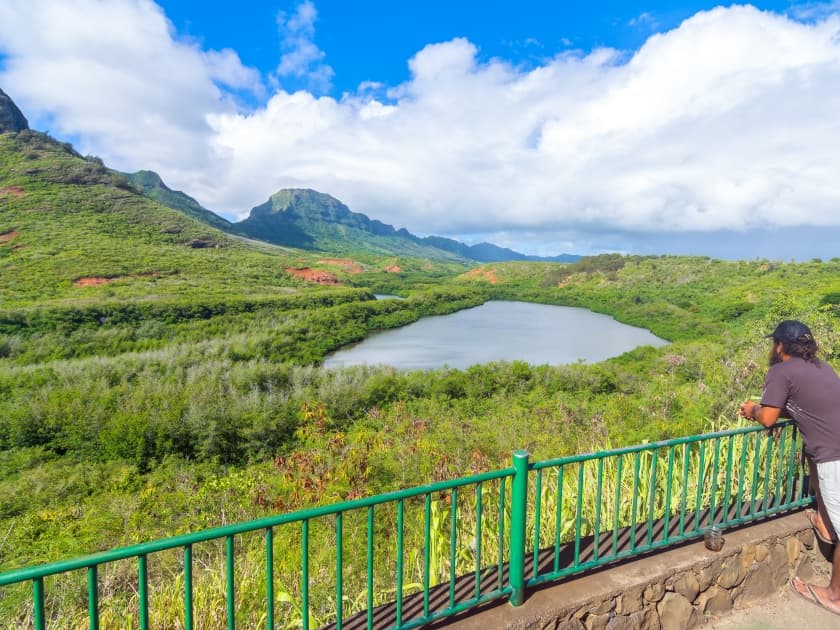
Waimea Canyon State Park includes a scenic drive, canyon lookouts, a viewpoint of Niihau Island, wildland picnicking and trails. Kōkee State Park rises to about 4,000 feet and opens toward Kalalau Valley, with a mix of picnicking, tent camping, lodging, native-forest birding, seasonal plum picking and trout fishing.
If you only have a short window: stay with the lookout corridor
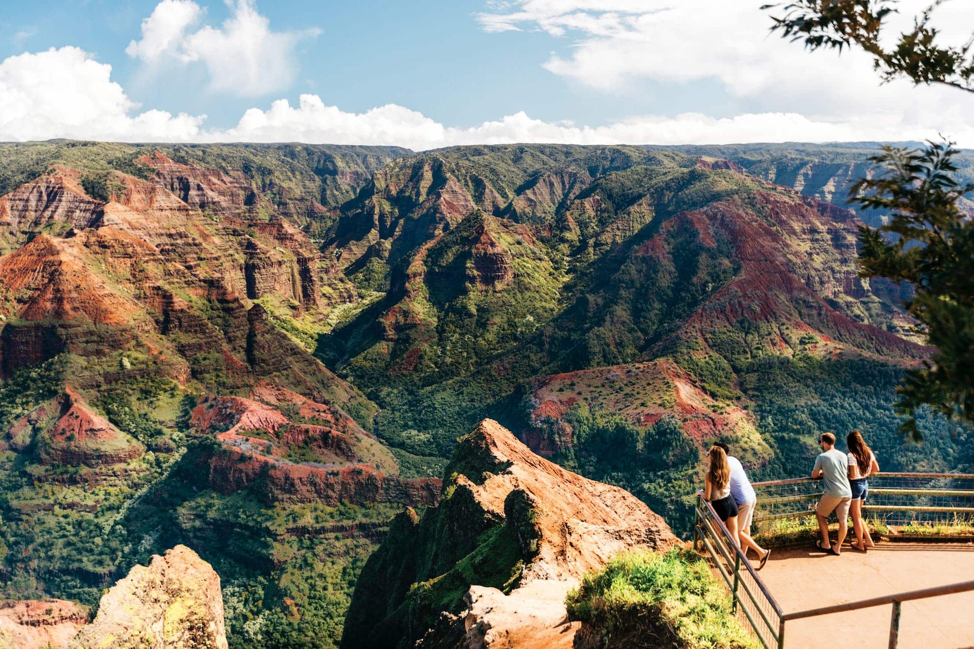
The fastest visit is the one that stays close to the road. Waimea Canyon Lookout, Puu Hinahina Lookout and Puu o Kila Lookout give you the classic rim experience without committing to a hike, and the canyon’s scale does the rest. Waimea Canyon is roughly 10 miles long and about 3,600 feet deep, by NASA’s estimate. It formed through the building of Kauai by a shield volcano and the long work of erosion and volcanic collapse.
This is the right choice if you want the view with the least physical effort, but it comes with tradeoffs. The rim is exposed, parking can be tight, and access conditions change with maintenance work. State notices warn visitors to expect delays and limited parking, and the Puu Hinahina lot remains closed for parking-lot striping. If you are coming from Waimea, Kekaha or Līhue, the lookout route works best as a straightforward day-trip stop, not a linger-and-wander plan.

If you want a family-friendly walk: choose the short trails
The easiest trail choice is Iliau Nature Loop, a 0.3-mile loop between mile markers 8 and 9 on Highway 550. It is rated easy and gives you dry shrubland, plant signs and sweeping canyon views without a major climb. For families, it is the cleanest compromise between scenery and effort, especially if you want something that feels like a walk rather than a workout.
Canyon Trail is the next step up. At 1.8 miles, it runs from Puu Hinahina Lookout or Halemanu Road toward Waipoo Falls and is rated moderate. It asks more of hikers than Iliau does, but it still fits a half-day plan for people who want a real trail experience without heading into the most exposed terrain. The main tradeoff is sun and footing, especially if you are pairing it with a lookout visit or carrying kids, snacks and water.
If you want cooler air and forest cover: go up to Kōkee
Kōkee is the better answer when the canyon rim feels hot and dry. The park sits around 4,000 feet elevation, and that higher ground brings cooler temperatures, more forest cover and views into Kalalau Valley. It also changes the mood of the day: what feels bright and open at Waimea Canyon can turn damp, shaded and much colder in Kōkee.
Kauai’s coldest recorded temperature, 26 degrees, was logged at the Danford House in Kōkee in February 1941. Pihea Trail runs 3.8 miles one way and comes with a warning about deep mud at Pihea peak. The Alakai route pushes the experience even further into the wet, high-country side of the park.

The Kōkee Natural History Museum is the best first stop for this side of the mountain. Hui o Laka has operated the museum for 70 years, and the museum first opened on November 28, 1953. It is open daily, free to visit and supported by donations. Local leaders Joseph M. Souza, Ruth Knudsen Hanner and Isabel Faye helped launch the museum as a community project, and it is one of the most useful places to pick up maps and brochures before heading farther in.
If you want a serious hike: plan for ridge views and steep returns
For hikers who want the real demand of the terrain, Awaawapuhi Trail is the signature ridge walk. It is 3.1 miles one way near mile marker 17 on Kōkee Road and ends at a ridge top about 2,500 feet above sea level with views into Awaawapuhi and Nualolo valleys. The reward is the kind of cliff-edge panorama that people remember for years, but the tradeoff is exposure, distance and a return climb that tests legs and timing.
Kukui Trail is the other serious option, and it is the one to choose if you want a descent into the canyon itself. The trail runs 2.5 miles and drops 2,000 feet to the canyon floor before continuing toward Waimea Town. That makes it a very different outing from a lookout stop or a short loop, because every step down commits you to the climb back up or to a longer logistical plan.
What the park needs from visitors now
A 2025 notice closed Waimea Canyon Lookout for safety improvements beginning July 14, 2025 and warned of overlapping roadwork, delays and limited parking. A 2026 notice kept Kōkee camping closed for campground improvements beginning in May 2026 and lasting through spring 2027.
This article was produced by Prism’s automated news system from verified source data, official records, and press releases, then run through automated quality and moderation checks before publishing. The system is built and supervised by the people who set the standards it runs under. Read our full AI policy.
Did this article answer your question?