Cibola Valley habitat restoration highlights La Paz County river corridor
Cibola Valley now shows La Paz County’s river corridor in recovery, with 1,309 acres of restored habitat, birdlife, and a direct link to the lower Colorado’s history.
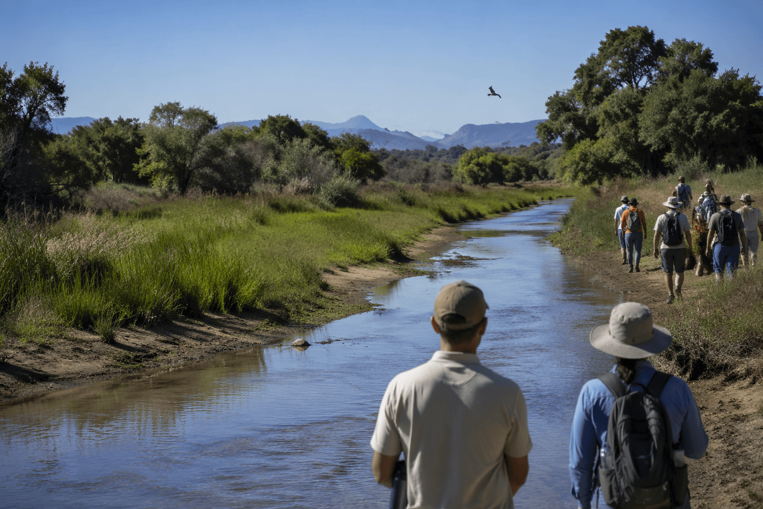
Cottonwoods now mark a stretch of the lower Colorado River in La Paz County where habitat was once simplified by channel work and flood control. At Cibola Valley Conservation and Wildlife Area, native planting has turned a bend of river, a remnant oxbow, and former agricultural ground into a visible example of what restoration looks like on the ground.
A river bend rebuilt as habitat
Cibola Valley Conservation and Wildlife Area covers 1,309 acres of agricultural fields and undeveloped land in La Paz County, following a bend of the lower Colorado River on the west side of the river. The site sits in the historic floodplain between river miles 99 and 104 and lies immediately north of Cibola National Wildlife Refuge, putting the two properties together into one river corridor story rather than two separate conservation sites.
The point of the work is easy to see in the habitat types now being rebuilt. Arizona Game and Fish says the area has been planted with native vegetation to restore cottonwood-willow, mesquite, and desert upland habitat types, the kind of plant communities that once fit the river’s natural rhythm much better than a stripped, altered floodplain does. Cottonwoods dominate parts of the wildlife area because they were planted as mitigation, making the restoration visible even from a distance.
What changed on the ground
Before restoration, this part of the river corridor reflected the legacy of a more controlled Colorado River, one straightened, channelized, and armored to prevent flooding. That engineering protected infrastructure, but it also reduced the shifting edges and backwater habitat that supported riparian life along the river’s historic floodplain. In Cibola Valley, the response has been to put native structure back into the landscape, one planted stand at a time.
That shift matters because habitat is not just about scenery. Cottonwood-willow patches create nesting and foraging cover, mesquite adds another layer of habitat complexity, and desert upland openings give the area a mix of edge and interior conditions that attract different species. The result is a corridor that looks and functions more like a working floodplain than a flat, simplified expanse.
Birds, bats, and the wildlife viewers who follow them
The restoration is already legible in the species that use the area. Arizona Game and Fish lists Gila woodpeckers, Sonoran yellow warblers, summer tanagers, vermilion flycatchers, and yellow-billed cuckoos among the birds associated with the wildlife area, along with California leaf-nosed bats, other bat species, coyotes, and Colorado River cotton rats. For visitors, that means the value of the site is not abstract conservation language, but a place where the return of native vegetation changes what can be seen and heard along the river bend.
Cibola National Wildlife Refuge next door expands that wildlife picture. The refuge supports migratory birds, wintering waterfowl, and endangered and threatened species, and it includes several miles of historic river channels and backwaters. Bird resources for the refuge list 287 bird species, including the endangered Ridgway’s rail and wintering sandhill cranes and western Canada geese, making this one of the most species-rich stretches of river country in western Arizona.
The climate adds another layer of realism to any visit. The refuge can reach 120 degrees in summer and gets about two inches of rain a year, so the corridor is a place where seasonal timing matters as much as binoculars. Winter and migration windows are the moments when the habitat’s payoff is easiest to see, especially for birders and other wildlife watchers moving through La Paz County.
Why the policy backdrop matters here
The land and water rights for Cibola Valley Conservation and Wildlife Area are leased to the Bureau of Reclamation through 2055, and the arrangement sits inside the Lower Colorado River Multi-Species Conservation Program. That program was built as a long-term way to balance Colorado River use with conservation of native species and habitat, which is why Cibola Valley can be read as both a local wildlife area and a piece of basin-scale water policy.
The program itself is a 50-year adaptive management effort. The U.S. Fish and Wildlife Service says it provides conservation for 27 covered species and 5 evaluation species and manages 18 conservation areas along the lower Colorado River, while the Bureau of Reclamation describes the broader effort as a conservation initiative for 32 native species across nearly a quarter-million square miles of the Colorado River Basin. That scale helps explain why a relatively small 1,309-acre site in La Paz County carries so much weight in regional planning.
The nearby refuge also places Cibola Valley inside a broader conservation geography. The lower Colorado corridor around Cibola is part of Arizona’s Imperial-Cibola conservation opportunity area and an Important Bird Area, which reinforces the connection between habitat work, bird diversity, and long-range river management. This is not an isolated pocket of green space; it is part of a linked corridor where federal, state, and local priorities meet.
What you can actually do there now
The clearest way to experience Cibola Valley is through wildlife viewing and birding. Arizona Game and Fish includes the area on its Where to Watch Wildlife and Arizona Birding Trail resources, so the site is meant to be read as a destination, not just a line item in a habitat plan. In practice, that means looking for the contrast between restored cottonwood stands, mesquite pockets, and open desert edges, then watching how birds and other wildlife use each layer.
That on-the-ground experience is what makes the restoration story useful to La Paz County readers. The corridor shows what a river bend looks like after habitat has been rebuilt from the ground up, and it gives birders, travelers, and local residents a place where the consequences of floodplain history are still visible in the trees, the channels, and the species that now return to them.
This article was produced by Prism’s automated news system from verified source data, official records, and press releases, then run through automated quality and moderation checks before publishing. The system is built and supervised by the people who set the standards it runs under. Read our full AI policy.
Did this article answer your question?