Lake Superior paddling in Silver Bay demands serious safety precautions
Silver Bay’s launch points open onto stunning water, but Lake Superior can turn lethal fast. The Hesper wreck and active ore boat traffic make local knowledge and cold-water prep essential.
In Silver Bay, a calm launch can turn into a serious open-water decision within minutes. The Minnesota portion of the Lake Superior State Water Trail runs about 150 miles from Duluth to the Canadian border and crosses a 32,000-square-mile lake that holds about 10% of the world’s fresh water.
Why Silver Bay demands caution
Silver Bay sits about 56 miles northeast of Duluth on U.S. Highway 61, with a 2020 Census population of 1,857. That small city anchors one of the most important access points on the North Shore, but the shoreline there is not a casual place to improvise a trip. Lake Superior’s rocky shore is often treacherous, summer weather can shift into life-threatening conditions in minutes, and the Minnesota Department of Natural Resources does not recommend canoes because sea kayaks are better suited to the lake’s windswept conditions.
The cold matters as much as the wind. Boating accidents are five times more likely to be fatal when the water is colder than 60 degrees, the DNR says, a number that should shape every decision about clothing, route length, and whether to go at all. Even in July or August, paddlers on Superior need to think in terms of immersion, not just exercise.
Choose the right craft and the right company
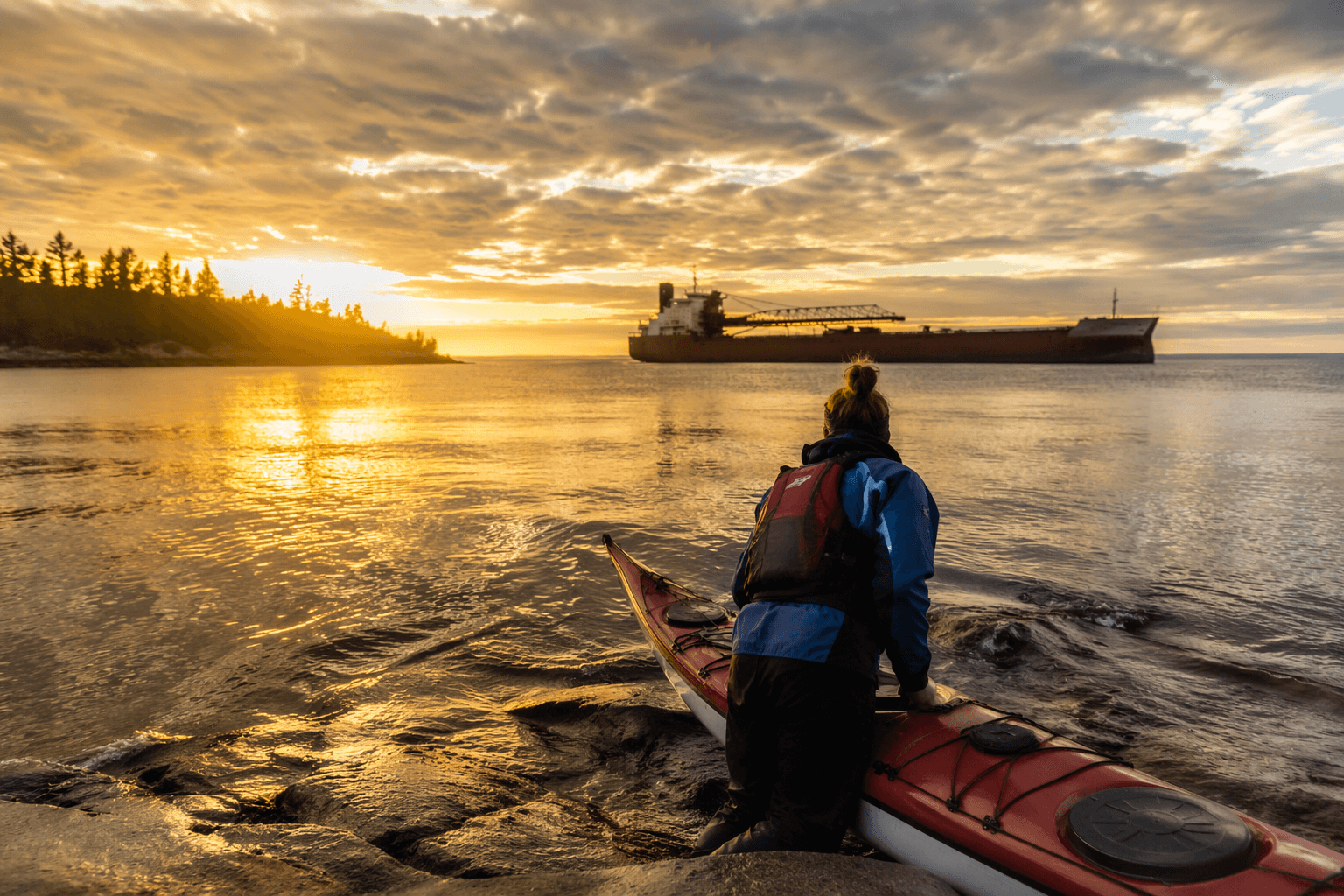
A protected launch does not make the lake tame. At the Silver Bay Marina, the access site is protected, but Silver Bay Harbor is a commercial-vessel transit area with large ships moving through 24 hours a day. That means a paddler is not just sharing water with waves and wind, but also with working traffic tied to the pellet plant and the ore boats that serve it.
For that reason, travel with a companion or a group rather than alone. Groups are safer when they stay within visual or verbal contact, discuss safety before leaving shore, and practice kayak rescues before heading out. On Lake Superior, a separated partner or an unpracticed self-rescue can turn into a rescue call.
What to carry before you leave shore
A proper Superior trip starts with gear that can handle a flooded boat and a sudden change in weather. The DNR specifically recommends carrying a pump for flooded boats, monitoring the weather, and keeping a marine VHF radio on hand. They let paddlers respond when spray, swell, or wind turns an easy crossing into a stranded one.
Clothing should match the cold water risk, not the air temperature at the parking lot. A paddler who plans to stay close to shore can still end up in the water, and Superior does not forgive hesitation after a capsize. Extra caution is warranted anywhere the route exposes you to open fetch, fast-moving weather, or a difficult landing.
What the Silver Bay launch actually offers
Silver Bay Marina is the launch point for paddling past rugged shoreline and the historic Hesper shipwreck, with a clear instruction to keep 300 feet away from ore boats loading at the pellet plant when they are in the area. The harbor is active industrial water.
From the water, the route also gives paddlers a compact lesson in Lake County geography. The mouth of the Beaver River lies about 1.5 miles west of the marina, and a black-rock beach is roughly 3.5 miles upshore from the ore docks. Those landmarks help define how much shoreline is available for a short outing and where wind, waves, and traffic become part of the route.
The Hesper is history, and a warning
The wooden steamer Hesper was built in 1890 and lost in 1905, and its wreck now lies about 30 to 50 feet below the surface near Silver Bay Harbor. It was listed on the National Register of Historic Places in 1994, recognizing its place in Great Lakes maritime history.
The Hesper struck a reef near present-day Silver Bay during a northeaster on May 3, 1905, and an enormous wave rolled the vessel over the reef. The crew escaped before the ship sank. Today, the wreck sits only about 300 yards from the interpretive panel at the marina.
It is valued for what ship remains can reveal about construction methods and materials tied to Great Lakes vessel types associated with the iron-ore industry and Minnesota’s grain trade.
How to read the lake before launching
The safest Silver Bay paddle starts by matching the route to the conditions. If the wind is rising, if the water is cold, if fog is building, or if you are not confident in a self-rescue, the better choice is to stay in protected water or not launch. Travel with a companion, use sea kayaks rather than canoes, and stay alert to weather and marine radio traffic.
This article was produced by Prism’s automated news system from verified source data, official records, and press releases, then run through automated quality and moderation checks before publishing. The system is built and supervised by the people who set the standards it runs under. Read our full AI policy.
Did this article answer your question?