Las Animas County map page puts roads, parcels and districts online
Las Animas County’s map page puts roads, parcels, districts and fairgrounds in one official place, helping residents avoid costly mistakes over access, boundaries and planning.
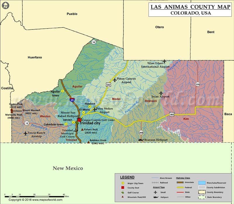
Las Animas County’s map page is more than a convenience layer. In a county that spans 4,772.94 square miles and had 14,555 people in the 2020 census, one official place to check roads, parcels and districts can settle questions that affect property, travel and local government decisions.
What the county map page already puts online
The county’s official County Maps page links to Roads, Structures, Parcels and Subdivisions, Commissioner Districts and Fairgrounds Facilities Rentals. It also sits alongside county contact details, including 719-845-2568 and weekday office hours, which makes it part of the county’s public-facing GIS service rather than a hidden technical archive.
That matters because the county has been publishing web-based GIS data for years. Its ArcGIS item was uploaded from ArcGIS Pro on Jan. 12, 2020, showing the county has treated digital mapping as an ongoing public tool, not a one-time project.
Roads are the first line of practical use
The Roads map is the most obvious place to start when a route question turns into a real-world problem. In a county with a population density of about 3 people per square mile, courtesy of Census Reporter, road access is not abstract geography. It is the difference between reaching a ranch gate, finding a rural address, or knowing whether a route is open enough for a visitor, delivery driver or emergency vehicle.
A generic navigation app can point you toward the fastest highway route, but it will not always answer the local question of how county roads connect to a parcel, where a road turns to dirt, or which road name a resident actually uses. The county road layer is the better check when a trip, closure or access issue could affect response time, mail delivery or whether someone can get to a property at all.
Parcels and structures help settle boundary questions
The Structures layer adds another level of detail by showing developed sites in places where settlement is scattered across Trinidad, Las Animas and the county’s many outlying areas. That can help a landowner confirm where a building sits, a buyer understand what is actually on the ground, or a neighbor compare a fence line with what the county has mapped.
The Parcels and Subdivisions map is even more important when property lines are at stake. Las Animas County has 15,307 parcel records in one commercial parcel dataset, and Regrid also promotes parcel data for the county, but the county assessor’s records remain the authoritative place to check when ownership, tax valuation or a boundary question could turn into a dispute.
The Las Animas County Assessor’s Office says Colorado law requires county assessors to list and calculate the value of all real and personal property for tax purposes. That makes parcel mapping a core part of property administration, not just a visual reference. If a parcel line is wrong in someone’s mind, the result can be a permit snag, a tax question, a closing delay or a neighbor fight that could have been avoided with the county map.
Commissioner districts show how county government is divided
The Commissioner Districts map is the civic layer with the most direct government impact. It tells residents which part of the county they live in for purposes of county representation, public comment and local decision-making, instead of forcing them to guess based on town names alone.
That is not a theoretical need. A redistricting map was released after several years of extensions tied to COVID-19 impacts, which shows that district boundaries can become a live public issue rather than a static line on paper. When people are trying to understand who represents them on the Las Animas County Board of County Commissioners, the district map is the clearest place to start.
The fairgrounds link supports event planning, not just navigation
The Fairgrounds Facilities Rentals link turns the map page into a planning tool for events and public gatherings. The county fairgrounds at 200 East 1st Street in Trinidad sit inside a network of county-managed facilities, and the rental policies show how seriously the county treats that use.
Those policies and procedures were adopted on June 8, 2010, revised in February 2019, updated again for pricing in February 2019, excluded county organizations from rates and fees on May 7, 2019, and extended operating hours on June 23, 2022. That timeline matters because it shows the fairgrounds are not just a venue, but a managed public asset with rules, fees and hours that people need to know before they book space or plan an event.
The fair itself has deep local history. Southern Colorado Tourism says the Las Animas County Fair officially began in 1911, and the 2026 fair entry window ran from May 13, 2026 to July 1, 2026, with late entries carrying a $50 fee per exhibitor. For anyone trying to line up livestock, exhibits or other fair-related plans, the county’s map and rental pages help connect the venue to the county’s broader schedule and geography.
Why the official map beats hearsay and third-party apps
County maps matter most when the stakes are practical. A rumor about a boundary line can lead to a fence or setback dispute. A wrong road assumption can send a driver to a blocked route or confuse emergency access. A third-party app can be useful for a first look, but it will not carry the same weight as the county’s own GIS layers when a permit application, a property question or a district issue depends on precision.
Las Animas County’s map page does something simple and important: it turns roads, parcels, districts and fairgrounds into public information that residents can actually use. In a county this large and this sparsely populated, that official map is often the difference between a fast answer and a costly mistake.
This article was produced by Prism’s automated news system from verified source data, official records, and press releases, then run through automated quality and moderation checks before publishing. The system is built and supervised by the people who set the standards it runs under. Read our full AI policy.
Did this article answer your question?