Heavy rain could bring 3 inches to Helena area this weekend
Up to 3 inches of rain could swell Tenmile Creek, flood-prone streets and low spots in the Helena Valley as weekend runoff builds.

Rain that looks like a nuisance in Helena can become a flooding problem fast, and this weekend’s forecast put that risk squarely on the table for Lewis and Clark County. The heaviest concern centers on low-lying parts of the Helena Valley, the Tenmile Creek and Prickly Pear Creek corridors, and roads that already struggle with runoff when storms stack moisture on top of high groundwater.
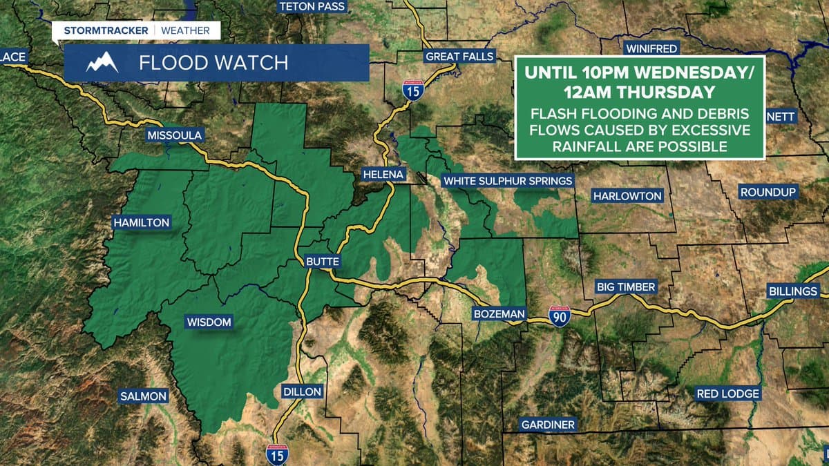
The National Weather Service office in Great Falls said periods of rain were expected through Sunday night, with most areas likely to receive 1 to 2 inches and a few isolated higher amounts. The National Weather Service office in Missoula went further, warning that a period of heavy rain from Saturday afternoon through Monday could bring widespread 1 to 2 inches and as much as 3 inches along the Divide, with minor flooding possible in urban and flood-prone areas and streams and rivers likely to rise.
County hydrologic outlook materials dated May 29 said the overall chance of flooding remained low, but local streams were expected to rise. Tenmile Creek was running about 1.5 feet below flood stage, and groundwater remained high in parts of the central Helena Valley, especially along Tenmile Creek and Prickly Pear Creek. That combination matters in Helena because runoff does not always need a major storm to create trouble; saturated ground and poor drainage can push water into streets, ditches and basements before a creek officially spills over.
Lewis and Clark County’s floodplain program says May and June are the county’s peak flood months, the wettest stretch of the year, and the county has seen major flood events in 1975, 1981, 1996, 2011 and 2018. The county has participated in the National Flood Insurance Program since the 1980s, adopted FEMA Flood Insurance Rate Maps on Sept. 19, 2012, and updated its floodplain ordinance in November 2022.

The 2018 flood remains a local reference point because water reached Rossiter Elementary School and roads closed near Sierra Road. That is the threshold residents should watch for now: water collecting where it should not, creeks rising instead of settling, and travel routes in east Helena and the valley slowing before they become impassable. The county also installed National Weather Service rain gauge GW6495 in July 2025 in the Horse Gulch Burn Scar area to strengthen flood-after-fire preparedness, a reminder that runoff can become especially dangerous where fire has stripped the land bare.
For people with weekend drives, outdoor plans or camping trips, the safest move is to check conditions before leaving and pay close attention if ponding starts on roads or small streams begin climbing. In Lewis and Clark County, that is often the difference between a wet weekend and a flood response.
This article was produced by Prism’s automated news system from verified source data, official records, and press releases, then run through automated quality and moderation checks before publishing. The system is built and supervised by the people who set the standards it runs under. Read our full AI policy.
Did this article answer your question?