McDowell County marker trail reveals coal and labor history
McDowell County’s 37 markers trace coal, war, health care and civil rights across Welch, Ashland, Algoma and Kimball, turning the county into a driveable history map.
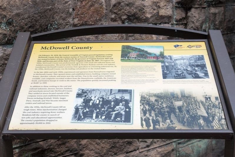
McDowell County can be read from the roadside if you know where to stop. Historical Marker Database lists 37 historical marker and war memorial entries here, enough to build a self-guided trail that follows coal, rail, floods of labor and migration, military service, and the institutions that held towns together.
The county’s scale helps explain why the markers matter. e-WV says McDowell County was founded in 1858, covers 535 square miles of land, and had 19,111 residents in the 2020 census, with a 2025 estimate of 16,878, down 11.7 percent. A 2024 video on the county described Welch and Kimball as part of the former “Coal Town USA” region and said the county once had about 100,000 residents, a reminder that today’s compact population sits inside a much larger coal-era footprint.

Start in Welch, where county government met the railroad
Welch is the county seat, and it is the right place to begin because its story ties government to extraction and transportation. The county history page says McDowell County was created on February 20, 1858, when Tazewell County was divided and its western half became a new county named for James McDowell, a former Virginia governor. Welch itself was named for Captain Isaiah Welch, who bought land at the confluence of Elkhorn Creek and Tug Fork in 1888, and the Norfolk and Western Railway reached the town in 1891 before Welch was incorporated in 1893.
That sequence tells you why Welch became the county’s anchor. The Isaiah A. Welch marker points to the surveyor whose coal reports helped push rail development, while the Welch Emergency Hospital marker brings public health into the same frame. In a county where coal growth outpaced municipal amenities, a hospital marker is more than a memorial, it is evidence that care, not just production, had to be built into daily life.
Ashland and Algoma show the company-town landscape up close
From Welch, the trail turns naturally toward Ashland and then Algoma, where the coal-company footprint still reads in the names of places and markers. HMdb includes Ashland Coal and Coke and The Company Store in Ashland, while the state historic preservation office’s McDowell County nominations page lists the Algoma Coal and Coke Company Store and the Ashland Coal Company Store. Those properties show how a company-town economy shaped housing, credit, groceries and movement through town.
The 2018 coal heritage survey update prepared for the West Virginia Division of Highways shows that these places are not just old structures, they are documented historic resources. That matters because the county’s built landscape still reflects the power of coal companies to organize land use, work life and settlement patterns, especially in communities where one company’s store could sit at the center of daily survival.
Kimball ties labor memory to military memory
Kimball adds another layer. The Coal Company Town in Kimball marker identifies the town’s company-built origins, and the Frederick Kimball marker connects the place to the railroad leadership that helped shape its rise. Nearby, the Kimball War Memorial and the Kimball World War I Memorial give the town a public memory that reaches beyond coal.
The Kimball War Memorial has a West Virginia Encyclopedia entry, and a 2023 WVNS story about the World War I memorial said it highlights Black veterans’ fight for democracy. That detail matters in a county where Black workers, white workers, immigrants and their descendants all lived inside a system shaped by segregation, industrial hierarchy and wartime service. The memorial is not a generic tribute; it makes race and citizenship visible in a place often flattened into a coal-town stereotype.
Civil War markers widen the county’s story before the coal boom
The trail should also include the markers titled McDowell in the Civil War, Bushwhackers in McDowell, and Ethnic Population of McDowell County. Those titles alone show that the county’s public history is not one-dimensional. They point to wartime conflict, guerrilla violence, migration and the making of a diverse Appalachian population long before the coal era reached its peak.
That broader view matters because McDowell County’s history did not begin with the mines, and it did not end when coal employment declined. The county history page places its creation in 1858, before the Civil War and decades before the railroad-driven boom that made Welch, Kimball and Ashland so central. Reading those markers together shows how the county’s political boundaries, wartime experience and labor history all predate the company-town landscape visitors usually notice first.
How to drive the trail and what it reveals
A practical loop starts in Welch, moves on to Ashland and Algoma, then finishes in Kimball. In Welch, county government, rail beginnings and public health sit in the same small circle. In Ashland and Algoma, company stores and coal-company properties show how daily life was organized around mining. In Kimball, the memorials connect labor history, Black military service and the town’s company-town past.
That route works because McDowell County’s public history is spread across towns and roads, not trapped in a single museum. With 37 markers in a county of 535 square miles, and with the population now far below the coal-era peak of about 100,000, the trail offers a way to read why communities formed where they did and why their institutions still sit where they do.
This article was produced by Prism’s automated news system from verified source data, official records, and press releases, then run through automated quality and moderation checks before publishing. The system is built and supervised by the people who set the standards it runs under. Read our full AI policy.
Did this article answer your question?