How Pahrump’s master plan shapes land use and growth in Nye County
Pahrump’s master plan decides what gets built, delayed, or blocked. The real action is at the planning commission, where neighbors can shape the next wave of growth.
Pahrump grew from 36,441 people in 2010 to 44,738 in the 2020 Census, and that growth is shaped by a master plan, a zoning map and a planning commission that decides what can move forward, what gets slowed down and what can be contested before a project reaches the county’s final decision-makers. Those rules affect homes, storefronts, roads, water and the daily routines of people who live and work in Nye County.
What the master plan actually does
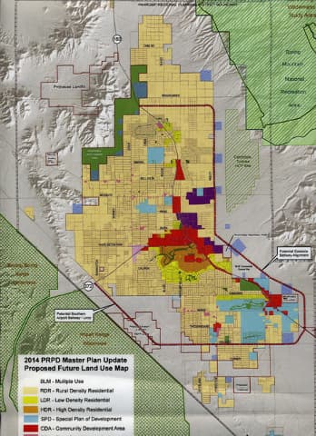
The Pahrump Regional Planning District is the county’s core land-use map, and Nye County treats the Pahrump Regional Planning Commission as the body that carries out Nevada’s planning statutes under the authority of the Board of County Commissioners. The county draws a bright line between the master plan and zoning: the master plan is the overall development guide for the district, while zoning is what divides land into districts and regulates private use.
That distinction matters because the master plan sets the direction for growth, but zoning determines what a parcel may actually be used for. Assessor land-use codes do not govern property use; only zoning does, which means a tax record or assessor label does not decide whether a property can host a home, a business or something else. For people weighing a purchase, a permit or a neighbor’s proposal, the zoning code is the rule that counts.
Why the 2023 update changed the playbook
The county’s updated master plan puts Pahrump’s growth in blunt terms. The plan says the community saw a 300 percent population increase after the 2003 plan and that the county needed a more flexible land-use guide to deal with housing demand, infrastructure pressure and public services. The original 2003 plan was completed on November 19, 2003 by Tri-Core Engineering with Consensus Planning, and the updated plan was adopted by the Board of County Commissioners on July 18, 2023.
The old zoning structure also became a problem. In 2003, the county had only two zoning categories, Open Use and Highway Frontage. The update says that lack of more specific zoning created uncertainty for investment, made banks reluctant to lend on some properties and contributed to incompatible land uses. The update also says the 2003 master plan helped establish the framework for the Adequate Public Facilities Ordinance, the Zoning Ordinance and the Streets and Highways Plan, which are the tools that tie growth to roads, services and the built environment.
Yucca Mountain, about 75 miles from Pahrump, added another layer of planning concern, county planning documents say. The county’s adequate public facilities policy describes Pahrump as an unincorporated town near the California border, about 63 miles from Las Vegas, and as a bedroom community where many residents commute to Las Vegas each day. That commuter pattern makes road capacity, drainage, law enforcement and solid waste disposal part of the same land-use conversation.
How a project moves through the system
Nye County has built a concrete review process around the Pahrump district. Pre-application meetings are required before applications move forward, and pre-development meetings are required before a Site Development application so planners, building staff, public works, fire and sheriff’s representatives can spot problems early. Applications do not reach an agenda until they are complete and fees are paid in full, which means missing paperwork can slow a project before it ever reaches public discussion.
The county also uses public notice to pull nearby property owners into the process. Hearing notices are mailed to property owners within 300 feet of an application, giving neighbors a formal heads-up before changes in land use or site design are discussed.

The Building Department ensures construction in the Pahrump Regional Planning District meets adopted codes, so land-use approval and building compliance are separate steps, not one all-purpose permission slip.
Where residents can speak up
The Pahrump Regional Planning Commission meets on the second Wednesday of each month at 2100 E. Walt Williams Dr. in Pahrump, usually at 6:00 PM unless otherwise noted. The commission acts on planning matters under authority from the Board of County Commissioners, and the board is the final authority on planning matters.
County meeting rules allow three minutes per person on off-agenda matters and on individual action items before votes. Residents can also sign up for agenda notifications for the PRPC, which makes it easier to follow projects.
The property questions that turn on zoning
A lot of the friction in Pahrump comes from everyday questions that look small until they hit the code. Temporary RV use in residential zoning is limited to 120 calendar days per year without a permit, and landscaping is governed by Title 17.04.740 and Appendix G of the Ground Water Management Plan. Those are the kinds of rules that affect how people stage a property, occupy it seasonally or keep a lot in compliance while building.
There is also a path for older uses that may not fit current zoning. Property owners who think a use may be grandfathered can seek a grandfathered-determination letter from the zoning administrator. That matters in a place where some properties were developed under older rules and are now surrounded by a much more complicated growth pattern.
Why the stakes keep rising
QuickFacts lists a 2020 to 2024 median gross rent of $1,304 and a median owner-occupied home value of $310,300.
Schools have been built or expanded and roadways improved to handle heavier traffic since the earlier plan, and the planning department now uses mapping and database systems to support planning and zoning decisions.
This article was produced by Prism’s automated news system from verified source data, official records, and press releases, then run through automated quality and moderation checks before publishing. The system is built and supervised by the people who set the standards it runs under. Read our full AI policy.
Did this article answer your question?