Booneville's Founding, Institutions, and Civic Landmarks Shape Owsley County Life
Booneville's county seat holds just 168 residents, yet it anchors 4,000 people across 198 square miles of Appalachian Kentucky with no hospital inside its borders.
A county born from compromise
The land grant that became Owsley County almost went to a different town. When the Kentucky General Assembly carved the county from parts of Breathitt, Clay, and Estill counties on May 20, 1843, commissioners spent months wrangling over where to put the seat of government. Citizens along the main Kentucky River pushed hard for Proctor, a small village named for the Reverend Joseph Proctor, a noted Indian fighter. It was the residents of the South Fork who held out for Booneville, pointing to a spring where Daniel Boone himself was said to have camped during a surveying expedition in 1780-81. The South Fork faction won. In 1843, Elias Moore, son of one of the county's first permanent settlers, donated an acre of land at that storied spring. The post office opened in 1844, and in 1846 the town was formally incorporated as Booneville, sealing the Boone name into the county's identity for good.
The Moore family connection runs deep. James Moore, Sr., had arrived in the 1790s and established what early maps called Moore's Station, and later Boone's Station. His son James Moore Jr. became the county's first postmaster. William Williams served as the first county court clerk, handling the land deeds and civil proceedings that gave frontier governance its paper trail. The first permanent settler families, the Moores, Bowmans, Bakers, Gabbards, and Reynoldses, staked out the hollows and ridgelines of a county that would eventually shrink as neighbors took pieces of it. Jackson County claimed a slice in 1858, Wolfe County followed in 1860, and Lee County was formed from remaining territory in 1870, leaving Owsley at its current 198 square miles.
The courthouse: records, fire, and resilience
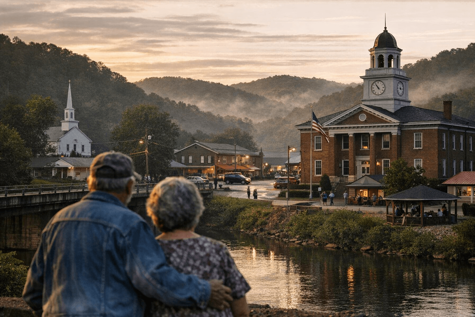
The original courthouse was a log structure, a temporary building that reflected the pragmatism of frontier government. What replaced it eventually became the civic center of a county that, by the 21st century, would rank as the second-least populous in Kentucky. A fire on January 5, 1967, badly damaged the newer courthouse building, a stark reminder of how fragile institutional infrastructure can be in a rural county without the tax base to rebuild quickly. Today the courthouse and the county clerk's office remain the indispensable hinge of daily civic life: property transfers, deed recordings, voter registration, and local elections all run through this building at the junction of Kentucky Route 11 and Kentucky Route 30 in the center of Booneville. For residents of the outer hollows, a trip to the courthouse is also a trip to town, which means it doubles as a de facto community gathering point whether the visit involves a land deed or a run for local office.
KY 11, KY 30, and the roads that decide everything
Booneville sits precisely at the crossroads of Kentucky Route 11 and Kentucky Route 30, on the South Fork of the Kentucky River. That geographic fact shapes nearly every aspect of daily life for the roughly 4,000 county residents who live across a landscape defined by ridges, creek drainages, and mountain roads. With no hospital inside Owsley County's borders, those roads determine how fast a family can reach emergency care. The Owsley County Health Care Center on County Barn Road provides skilled nursing, long-term care, and rehabilitation services, and the Owsley County Medical Clinic operates as a federally qualified health center offering primary care, but for anything requiring an emergency room or surgery, residents must drive to neighboring counties, including Clay, Breathitt, or Perry, a reality that makes road conditions and bridge maintenance a life-or-death budget question for the Owsley County Fiscal Court every year.
Over 30% of county residents live below the poverty line, and roughly 14% lack health insurance, which means the distance to a hospital is not just a logistical inconvenience; it is a compounding health-equity barrier that local officials and clinic staff have been navigating for generations.
Owsley County Schools: 742 students carrying the future
The Owsley County School District operates two schools, Owsley County Elementary and Owsley County High School, both anchored on Old Highway 11 in Booneville. Current enrollment stands at 742 students, with 84.5% classified as economically disadvantaged. The district employs roughly 158 staff members, meaning that in a county this size, the school system is one of the largest employers and one of the most consequential institutions in any family's daily rhythm.
Graduations at Owsley County High School are among the largest community gatherings in the county calendar. Sports seasons, especially basketball, still draw residents from across the ridges into Booneville. The schools also serve as adult education hubs, connecting working-age residents to GED programs and workforce training at a moment when the county's population has declined nearly 19% since 2010, from 4,755 residents then to an estimated 3,872 in 2025. That number, nearly one in five residents gone in 15 years, is the statistic that concentrates minds on the school board and the fiscal court alike, because a shrinking student body eventually means shrinking state funding, and a shrinking workforce means fewer local tax dollars to fill the gap.
A sculptor's gift: the Granville Johnson carving
Not every civic landmark in Owsley County is a government building. South of Booneville, a rock face on a hillside behind what was once the John Williams family farm holds a carving with an unusual origin story. In the 1930s, a traveling pack peddler named Granville Johnson arrived in Owsley County ill and in need of help. The Williams family took him in, nursed him back to health on their farm, and asked nothing in return. As Johnson regained his strength, he climbed the hill each day with a hammer and chisel. When he was well enough to travel again, he revealed the sculpture he had worked on in secret, carved as a gift of gratitude to the family that had saved him. The Owsley County Fiscal Court later purchased the carving and the surrounding land, preserving it as a public site. It is the kind of landmark that does not appear in any infrastructure budget but carries the county's character in a way a courthouse never quite can.
Churches, cemeteries, and the institutions between the institutions
Across Owsley County's 198 square miles, volunteer fire departments, longtime churches, and rural cemeteries perform the civic functions that no government agency fully covers. Local congregation rolls and church bulletins document the community's organizational life with a consistency that even municipal meeting minutes cannot match. The county's historic cemeteries serve as the most physically durable archives in the region: family names carved into markers connect present-day residents to the Moores, Gabbards, and Reynoldses who filed the first land patents. Obituary pages in the local community newspaper, preserved in archives and often shared by families across social media, remain one of the most-read forms of civic record in the county, documenting the volunteerism and service of the mid-20th and 21st-century residents whose names do not appear in any official ledger.
What's changed, what's missing
Owsley County once supported a broader range of small businesses and retail services than it does today. Economic patterns shifted across the 20th century as small-scale farming gave way to extractive industries in nearby counties and then to a growing reliance on outdoor tourism and recreation, with portions of the Daniel Boone National Forest, including access corridors toward the Red River Gorge, falling within county boundaries. What the county has lost in population and commercial density it has tried to offset with outdoor assets that attract visitors, but the gap between what existed in previous generations and what exists now, in terms of local retail, healthcare services within county lines, and school enrollment, is real and measurable.
For residents and civic leaders who want to understand how Owsley County got here and where the leverage points are for what comes next, the answer starts with the same institutions it always has: the courthouse on KY 11 and KY 30, the school district on Old Highway 11, the clinics on County Barn Road, and the fiscal court meetings where road budgets and service contracts are decided in public. Those are the rooms where Owsley County's next chapter is being written, one agenda item at a time.
This article was produced by Prism’s automated news system from verified source data, official records, and press releases, then run through automated quality and moderation checks before publishing. The system is built and supervised by the people who set the standards it runs under. Read our full AI policy.
Did this article answer your question?