Doubling Point Light highlights the Kennebec River’s maritime history
Doubling Point Light shows how the Kennebec moved cargo, pilots and shipbuilding traffic through Sagadahoc County. The county’s lighthouse loop still maps that working history.

The Kennebec River runs 150 miles from Moosehead Lake to the sea at Popham Beach in Phippsburg, a transportation corridor used for centuries by Native people and later European travelers moving between the Gulf of Maine and interior Maine. The lighthouse stops along Arrowsic, Georgetown and Seguin Island make that history visible, each marking a place where water, commerce and navigation collided.
The river beneath the view
The easiest way to read the county’s maritime landscape is to start with the river itself. The Kennebec has long been one of Maine’s most important waterways, and the mouth of the river at Popham Beach sits at the edge of some of the earliest European settlement in the region, including the 1607 Popham Colony. That older trade and travel pattern still shapes the county’s identity today, especially in Bath, where shipbuilding on the Kennebec stretches back to the 1762 launch of the Earl of Bute.
Bath still carries the name City of Ships for a reason. Generations of work on the river built that legacy, and Bath Iron Works remains the only active shipyard on the Kennebec River today. These lights guided river pilots, cargo traffic and ocean-bound vessels through a narrow, dangerous corridor.
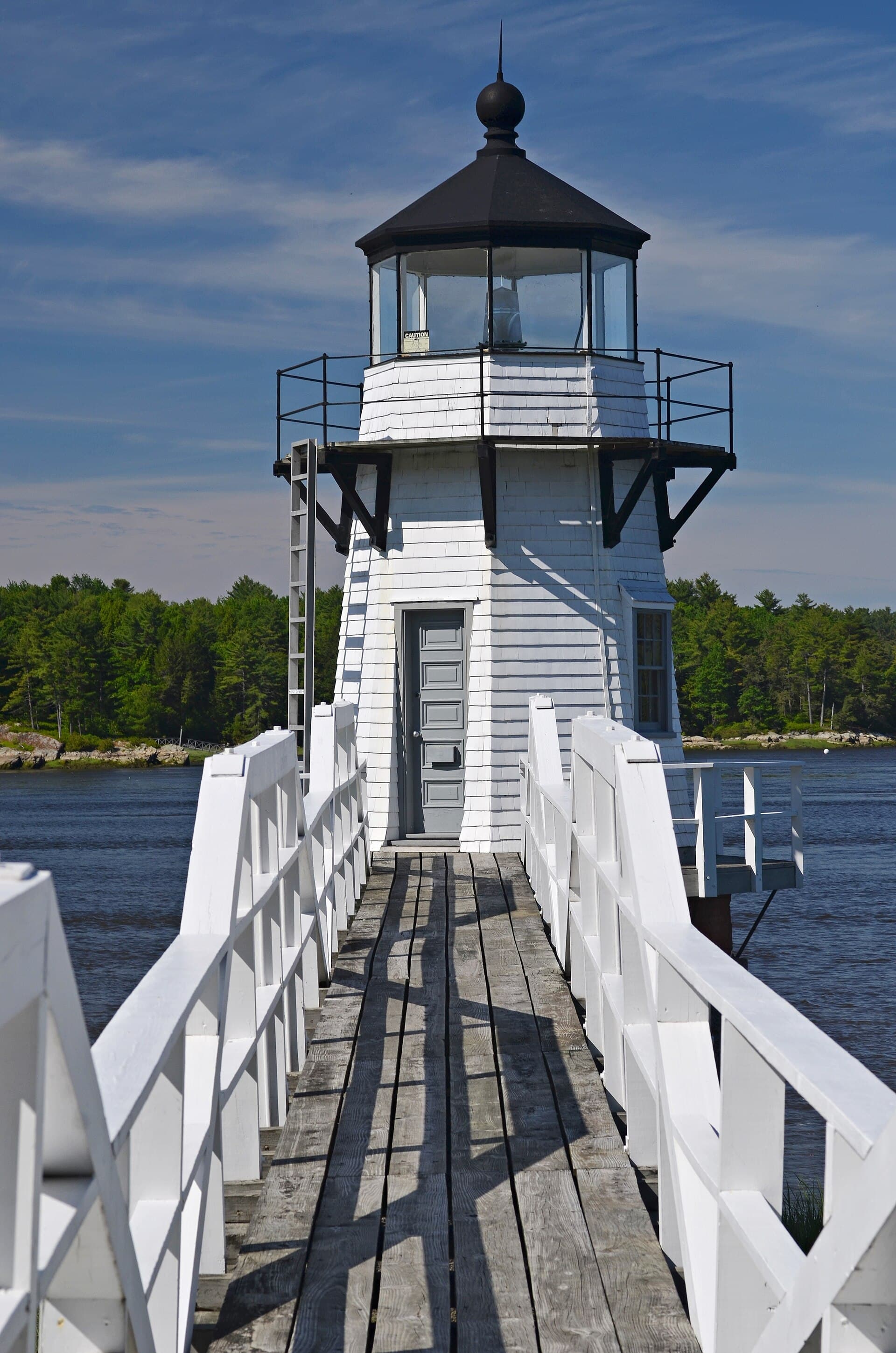
Doubling Point Light and the turns that made it necessary
Doubling Point Light, on the northwest end of Arrowsic Island, was established in 1898 for exactly that kind of work. It warns mariners about two hazardous double bends on the Kennebec, a stretch where timing and position mattered as much as visibility. Its wooden octagonal tower on a granite foundation is a modest, functional structure built for river navigation.
The station’s keeper history is just as spare and revealing. Only two keepers served there, Merritt Pinkham from 1898 to 1931 and Charles W. Allen from 1931 to 1935. The light station, except for the lighthouse itself, was sold to a private owner on August 13, 1935, for $2,200.
Preservation returned Doubling Point to public care in 1998, when Friends of the Doubling Point Light received stewardship under the Maine Lights Program. Congress passed that program in 1996, identified 36 Maine lighthouse properties as candidates for transfer and ultimately transferred 28 lighthouses from the Coast Guard to local groups or agencies. Doubling Point’s original 5th Order Fresnel lens now sits at the Maine Lighthouse Museum in Rockland, tying the site’s working history to a wider state collection.
Squirrel Point and the river’s shipbuilding spine
Squirrel Point Light, also on Arrowsic Island, belongs to the same river system and tells the story from a slightly different angle. It is one of four navigational aids dating back to 1895 along the 11-mile stretch between the Atlantic Ocean and the City of Bath, a compact reach of river where marine traffic, shipbuilding and coastal commerce all intersected. Citizens for Squirrel Point centers its mission on restoration, public access and community education.

The approach to Squirrel Point is part of what makes it memorable. The light sits at the end of a roughly two-thirds-of-a-mile trail in Arrowsic, about 10 miles from Bath, with access through protected forests and wetlands. That means visitors can still reach a historic aid to navigation on foot, following the landward side of a route that once mattered because boats needed a fixed point in a busy channel.
Perkins Island and Seguin Island, from river mouth to open water
Perkins Island Light Station adds a quieter chapter to the same corridor. The station was built in 1898, remains operational and automated, and sits on the western side of an undeveloped state park island in Georgetown, visible from across the river in Phippsburg.
Seguin Island Light stands at the opposite end of the route in scale and drama. Nearly 2.5 miles out to sea at the mouth of the Kennebec River, it was commissioned by George Washington in 1795 and is Maine’s second oldest lighthouse. Friends of Seguin Island lists the focal point of its lens at 186 feet above sea level, making it the highest lighthouse in Maine.
Seguin Island Light was added to the National Register of Historic Places on March 8, 1977. The Coast Guard automated and decommissioned it in 1985, the Friends of Seguin Island formed in 1986, and in 1995 the group received the deed to the 64-acre island and its buildings. The island’s 1895 tramway is Maine’s last working tramway. Visitors still reach it only by boat.
How to plan a day around the loop
A useful day trip through Sagadahoc County follows the river the way mariners once did: from the tight bends inland to the open water at the mouth. Start in Bath to understand the working city behind the coast, then continue to Arrowsic for Doubling Point and Squirrel Point, where the channel narrows and the navigation history becomes easiest to see on land.
- Stop at Doubling Point to see a practical river light built for turns.
- Walk the trail to Squirrel Point through protected forests and wetlands to a historic aid to navigation.
- Look across the river toward Perkins Island from Phippsburg to see how an active aid to navigation can still shape the view.
- Reserve Seguin Island for the most remote stop, with the offshore light, the deeded 64-acre island and the tramway.
This article was produced by Prism’s automated news system from verified source data, official records, and press releases, then run through automated quality and moderation checks before publishing. The system is built and supervised by the people who set the standards it runs under. Read our full AI policy.
Know something we missed? Have a correction or additional information?
Submit a Tip