Reid State Park draws summer crowds to Sagadahoc County coast
Reid State Park is where public access, crowd pressure and shoreline erosion meet. Its beaches, trails and nesting habitat shape summer life on Georgetown’s coast.

Why Reid matters now
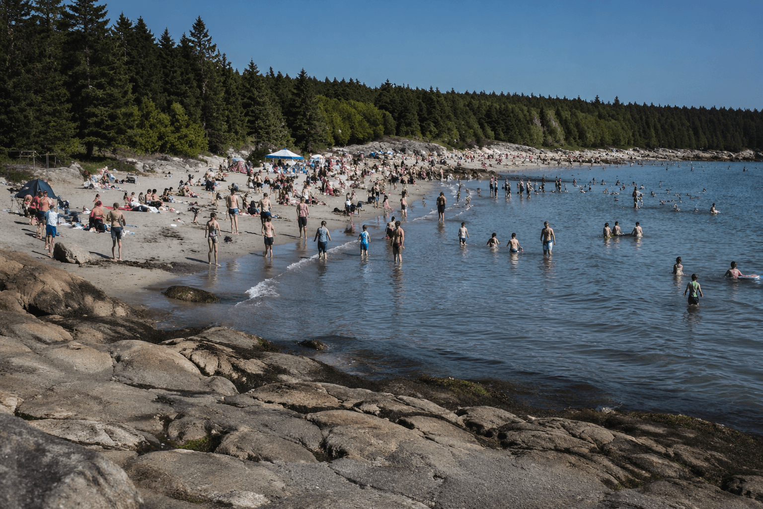
Reid State Park is one of the clearest places in Sagadahoc County where public shoreline access, summer crowding and local identity all collide. On busy days, the park is not just a beach stop. It is a public entry point to the coast, a traffic generator for Georgetown, and a reminder that access to Maine’s shoreline is still shaped by who can reach it, park it and stay long enough to enjoy it.
Managed by the Maine Department of Agriculture, Conservation and Forestry’s Bureau of Parks and Lands, Reid is one of Maine’s 48 state parks and historic sites and is classified by the state as a coastal park. That matters in a county where private shoreline, parking pressure and seasonal congestion can make the coast feel divided. Reid remains one of the places where that divide is lessened, even if only for a few summer hours.
What the park offers visitors
Reid is not a standard boardwalk beach, and that is part of its draw. The park combines sandy shoreline with rockier coastal features and walking opportunities, which makes it attractive to families, hikers, birdwatchers and anyone who wants direct Atlantic access without a built-up commercial edge. The landscape gives visitors a different experience from the more manicured beach destinations farther south and west, and it helps explain why the park holds such a strong place in the county’s summer routine.
One of the most useful ways to see the park is through the Little River Trail, which the Maine Natural Areas Program describes as a 2.8-mile easy walk. Along that route, visitors can move between ocean swells, rocky headlands and dune habitat, with the chance to spot least terns and piping plovers. It is a trail that blends recreation with observation, which is exactly why Reid draws such a wide mix of users.
Access, parking and the pressure of summer use
The park’s popularity comes with practical strain. On peak weekends, the biggest question is often not what to do once you arrive, but how to get in, where to leave the car and how crowded the shore will feel once you do. Those small decisions shape the experience for dozens or hundreds of people at a time, and they ripple into the surrounding roads and businesses of Georgetown.
State project documents show that access has been an active concern. Work tied to a control-station replacement included widening the access road, adding erosion-control measures and repaving. Later procurement documents called for regrading and paving the Griffith Head parking lot and reconstructing the East Beach parking lot. Those projects point to a simple fact: Reid’s summer demand is no longer something the state can treat as a background issue. It has to be managed with roads, lots and shoreline infrastructure that can absorb heavy use.
For nearby businesses, that pressure is not all bad news. Summer traffic brings more people past gas stations, restaurants and small shops, and that visitor flow can support the local economy even as it complicates daily movement for residents. In a place like Georgetown, the park’s popularity is both an asset and a test.
Beach conditions are changing
Reid’s shore is not static, and the state has been documenting that reality. In an October 16, 2024 beach-mapping update, the Maine Geological Survey reported notable erosion at Reid State Park. The state’s beach-mapping program began in 2005, and it has mapped the mean high-water contour since 2017, giving officials a longer view of how the shoreline is shifting over time.
That 2024 survey covered 42 sandy beaches from Kittery to Bristol, placing Reid in a broader pattern of coastal change across southern and midcoast Maine. The geology material also notes that Maine’s coast is continually reshaped by winds, waves, tides, storms and sea-level rise. At Reid, that means beach conditions can change, dunes can move, and access points can become more fragile even as visitor demand remains high.
For residents who may not spend every weekend at the park, that erosion still matters. Reid is part of the county’s outdoor infrastructure, and its condition affects how safe, open and usable the coast feels for everyone who depends on public access.
Wildlife protection is part of the park’s identity
Reid’s beach is also a working habitat. State wildlife guidance says Reid and Popham are examples of state parks where piping plovers and least terns can coexist with recreation if the site is managed properly. The park is also identified by state and tourism sources as important nesting habitat for endangered least terns and piping plovers.
That balance is one of the hardest and most important jobs on the Maine coast. The shoreline has to remain open enough for people to use, but protected enough for birds that depend on the same dunes and sand flats to nest and feed. At Reid, recreation and conservation are not separate stories. They are the same story, and the park’s value depends on keeping both in view.
A long-running public place with a deep local footprint
The history behind Reid helps explain why the park still feels so central to Sagadahoc County. Friends of Reid says Walter E. Reid donated 350 acres in 1946 to form the nucleus of the park, then added another 355 acres later, bringing the total to 779 acres. The park opened in 1950, and a Down East archive account said Reid drew 135,953 visitors in 1968, with people arriving from all 50 states and 13 foreign countries.
That scale is striking, but the local meaning is even more important. Reid has long been a place where Georgetown meets the wider coast, where a county shoreline becomes public rather than private, and where summer crowds bring both economic opportunity and logistical strain. As erosion continues, parking lots are rebuilt and nesting habitat is protected, Reid remains one of the clearest measures of how well Sagadahoc County is balancing access, conservation and the pressures of a crowded coast.
This article was produced by Prism’s automated news system from verified source data, official records, and press releases, then run through automated quality and moderation checks before publishing. The system is built and supervised by the people who set the standards it runs under. Read our full AI policy.
Know something we missed? Have a correction or additional information?
Submit a Tip