Sandoval County's Best Parks, Trails, and Historic Sites for Explorers
From the 12.4-mile Corrales bosque trail to Jemez pueblo ruins built the same year the Pilgrims landed, Sandoval County rewards every kind of explorer.
The Rio Grande Bosque: Corrales and the Cottonwood Corridor
The Corrales Bosque Preserve runs 12.4 miles alongside the Rio Grande, threading through a natural cottonwood forest that also takes in riparian shrubs like coyote willow and New Mexico olive. The terrain is flat, the shade is genuine, and the trail is open to walkers, hikers, horseback riders, and cyclists. (Motorized vehicles and e-bikes are not permitted.) The preserve holds official designation as an Important Bird Area, which means birders arrive with serious gear during spring migration and again in fall when waterfowl push through the river corridor. For everyone else, an early-morning bosque walk followed by a stop at the Corrales Farmers Market covers nature and neighborhood in a single unhurried outing.
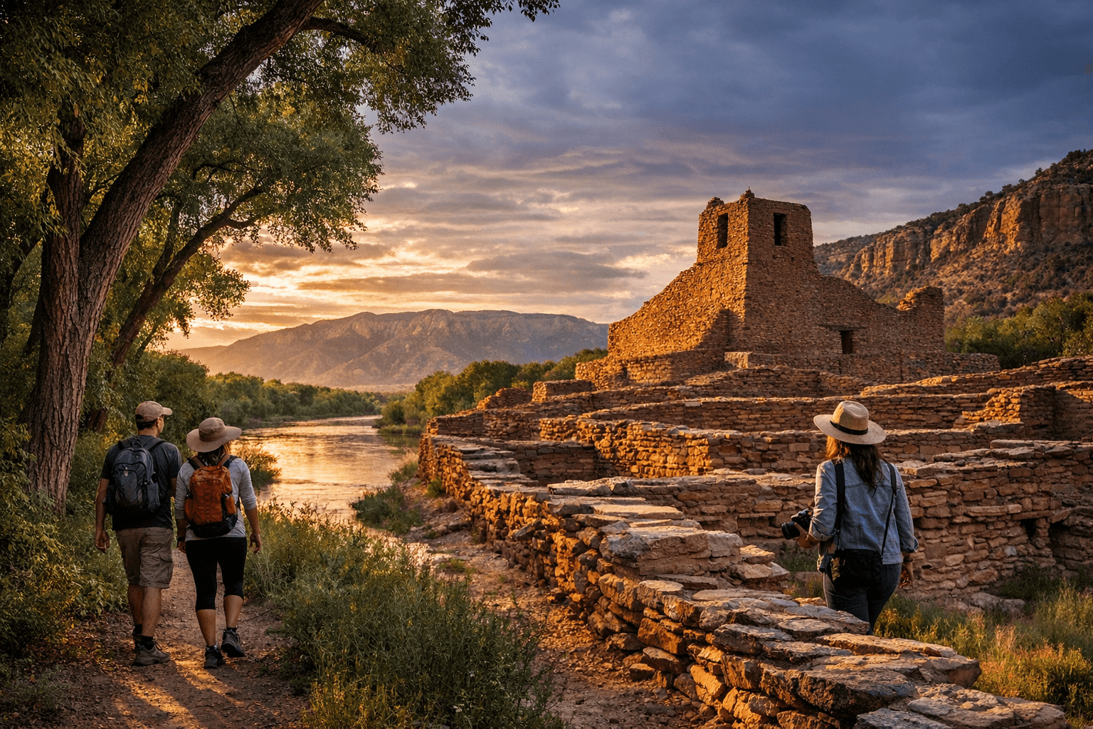
Jemez Historic Site: Pueblo Ruins and Canyon Trailheads
Follow NM-4 northwest into the Jemez Valley and the landscape shifts abruptly from scrubby high desert to red-rock canyon country. The Jemez Historic Site preserves the ruins of Giusewa Pueblo and the San José de los Jémez Mission, a massive stone structure completed around 1621 by Franciscan missionaries working alongside Jemez converts. Those walls were going up at roughly the same moment the Pilgrims were landing at Plymouth Rock. A 1,400-foot paved interpretive trail winds through the excavated site, with information panels drawing on the words and perspective of the Jemez people themselves, and a visitor center displays Pueblo artifacts and mission-era history.
The site is open Wednesday through Sunday; adult admission is $7, children 16 and younger enter free, and New Mexico residents with ID visit free on the first Sunday of every month. Beyond the monument itself, Jemez Springs sits nearby as a base for canyon hikes deeper into the Jemez Mountains and toward the periphery of Valles Caldera. Temperatures here run significantly cooler than the Rio Grande valley, and the combination of geothermal features, river picnic sites, and accessible trailheads makes this stretch of NM-4 an easy full-day destination.
Cochiti Lake: Water Recreation in a High-Desert County
Cochiti Reservoir fills a gap in Sandoval County's recreation menu that the desert landscape would otherwise leave open: a place to boat, fish, swim, and camp. The U.S. Army Corps of Engineers manages the lake and its associated recreation areas, which include shoreline access, camping, and launch facilities suited for family outings. Summer draws the biggest crowds, when anglers and boaters make full use of the warm water. Because this is a managed reservoir, water levels shift seasonally and conditions change with weather patterns. Check current conditions with the Corps of Engineers or local postings before loading the boat, especially after dry winters.
Caja del Rio and Cerro del Medio: Volcanic Plateaus, Wide Skies
Northwest of Rio Rancho, the Caja del Rio plateau stretches across a large volcanic landscape between the Rio Grande and the edge of Santa Fe County. Views from the rim trails reach toward Los Alamos and White Rock to the west and sweep south toward Albuquerque. The terrain itself is comparatively flat and rolling by New Mexico standards, which makes Caja del Rio and the adjacent Cerro del Medio area accessible for day hikers who want dramatic scenery without a technical climb. Sunrise and sunset light hits the plateau at angles that make it a magnet for landscape photographers; bring extra water, start early, and plan around the shade problem, which is essentially nonexistent on the open plateau.
Tamaya and Santa Ana Pueblo: Culture and Open Space Together
The Santa Ana Star Casino and Hyatt Regency Tamaya Resort sit within Santa Ana Pueblo's territory and offer a genuinely layered visit: cultural programming and interpretive events alongside the outdoor recreation that comes with the Pueblo's proximity to the bosque and the Rio Grande. The area supports some open-space trail access in the vicinity, making it possible to combine a cultural stop with a short walk through a landscape the Pueblo has managed for generations. Visitor access to Pueblo land is governed by specific rules and cultural protocols. Confirm guidelines before you go, follow posted signage carefully, and treat the landscape and any cultural features with the same respect you would give any historic site.
Rio Rancho City Parks: A Park Above and Veterans Memorial
Not every worthwhile outing requires leaving Rio Rancho. A Park Above, located on six acres off Westside Boulevard at 2441 A Park Above Court, holds the distinction of being New Mexico's first fully-inclusive and accessible playground, built to universal design standards so children of all abilities can use the space together. Veterans Monument Park, situated at 950 Pinetree Road, anchors the other end of the city's park system with a monument honoring military service and surrounding green space suited for everyday recreation. Both parks offer paved walking loops, open fields, and the kind of low-barrier outdoor access that turns a weekday afternoon into something worth leaving the house for.
Planning for New Mexico's Climate
Every destination in Sandoval County sits in an environment that punishes unprepared visitors consistently. A few non-negotiable principles apply across the board:
- Carry more water than you think you need. Dehydration risk is real at all elevations and in every season.
- Apply sun protection year-round. UV intensity at New Mexico's elevations exceeds what most visitors expect, even on overcast days.
- Check trail and road conditions before heading out, particularly after late-season storms or high-wind events that can wash out dirt access roads.
- Download offline maps or GPX waypoints for Jemez-area hikes. Cell service disappears quickly once you leave the valley floor.
- Pack layers for any destination above 6,000 feet. The Jemez Mountains can run 20 degrees cooler than Rio Rancho on the same afternoon.
- Follow Leave No Trace practices in bosque and riparian zones, where vegetation and nesting wildlife are especially sensitive to foot traffic.
Respecting Land and Cultural Protocols
Signage at Pueblo-managed and state-managed historic properties reflects real cultural rules, not just liability language. Observe what is posted, do not photograph without permission where prohibited, and confirm hours and fees before visiting sites like Jemez Historic Site, which keeps seasonal schedules. For mountain bikers and anyone considering off-trail travel, verify permitted uses with the relevant land-management agency in advance; several parcels near the Jemez Mountains and Caja del Rio carry seasonal closures to protect habitat and cultural resources.
Sandoval County's outdoor range spans from cottonwood-shaded river corridors near 5,000 feet to Jemez Mountain trails climbing well past 8,000 feet, with volcanic plateaus, a managed reservoir, an inclusive city playground, and pueblo ruins layered in between. The destinations hold up across seasons precisely because they are so different from one another: the right choice on any given day depends on weather, energy level, and how much planning you are willing to do. That planning is always worth it.
This article was produced by Prism’s automated news system from verified source data, official records, and press releases, then run through automated quality and moderation checks before publishing. The system is built and supervised by the people who set the standards it runs under. Read our full AI policy.
Did this article answer your question?