Seminole County tracks lake health, water quality with public dashboard
Seminole County’s dashboard lets you check lake, river and spring conditions before you fish, swim or boat, and it ties those readings to watershed management.
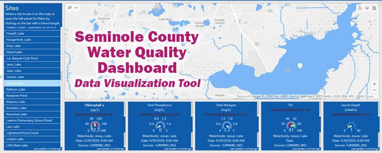
Before you launch a boat at Red Bug Lake Park, plan a swim at a neighborhood lake, or decide whether to fish the Little Wekiva River, Seminole County gives you a place to check the water first. Its public dashboard and Water Atlas are built to show the most recent monitoring data for rivers, lakes and springs, so residents are not left guessing when water looks cloudy, a shoreline looks stressed, or an algae alert changes the day’s plans.
How the county’s dashboard works
Seminole County’s Water Quality Dashboard Help page says the dashboard presents the most recent monitoring data geographically through an interactive, dynamic interface. That matters because the county is not posting a single countywide number and calling it done. Instead, the system is built lake by lake, river by river and spring by spring, so a search can focus on the waterbody that affects a specific neighborhood, park or launch point.
The Seminole County Water Atlas, presented by Seminole County and the USF Water Institute, adds another layer. It includes a “Find a Waterbody” search, a maps and data section, and a Water Quality Dashboard that shows current water quality conditions for lakes, rivers and springs using dashboard technology. The atlas is designed for citizens, scientists, professionals and planners, which explains why the same platform can serve a weekend boater, a shoreline resident and the county staff managing a restoration project.
What to check before you use a lake
The practical value of the system is simple: it lets you make decisions based on conditions, not rumors. A lake page can show an impairment badge, which signals that the waterbody is being tracked for a status concern rather than just listed as another local lake. Separate county pages for biological monitoring, NPDES stormwater work, lake level information and LakeWatch participation show that the county is watching more than surface appearance.
When you open a lake page, check these items first:
- current water quality conditions for the waterbody you care about
- any impairment badge or warning flag on that page
- lake level information if you are worried about docks, shorelines or nearby drainage
- biological monitoring data if you want a fuller picture than a single snapshot
- stormwater-related information if recent rain has pushed runoff into the basin
That broader monitoring matters when conditions change quickly. Florida Department of Health in Seminole County issued a Blue-Green Algae Health Alert for Lake Howell in June 2026, a reminder that one lake can move from routine monitoring to public caution without much warning. For residents, that is the difference between a normal afternoon on the water and a day to stay out.
Why watershed information matters as much as the lake itself
Seminole County’s Citizens’ Guide to Lake Management makes the central point plain: the water quality of a lake directly relates to the quality of water entering the lake from its surrounding watershed. That means algae blooms, murky water, shoreline stress and other problems do not begin at the lake’s edge. They often begin upstream, in runoff, stormwater design and land use around the basin.
The county’s Water Atlas also notes that monitoring macroinvertebrate life in streams helps scientists assess water quality. That is a technical way of saying the county looks at what lives in the water, not just how it looks from the bank. For a county with lakes, rivers and springs spread across Sanford, Lake Mary, Oviedo, Altamonte Springs and unincorporated areas, that kind of system is the only way to connect a neighborhood’s drainage pattern to the health of the water people actually use.
How the county organizes lake management
The county’s 2026 Lake Management Newsletter says the Watershed Management Division’s mission is to protect, conserve and restore Seminole County’s water resources. The 2020 lake-management guide places that division at 200 West County Home Road in Sanford, Florida 32773, with phone number 407-665-5542. An earlier Water Atlas-hosted booklet shows the older Seminole County Department of Public Works Roads-Stormwater Division address at 177 Bush Loop in Sanford, Florida 32773, with phone number 407-665-2439.
Those details show that the work is not just a webpage. It is an operational county function with staff, offices and a changing administrative history. The Water Atlas pages also show a 2023 Grace Lake Lake Management Plan with agenda material, budget and financial summaries, historic reports and data, county services, planned treatments and funding, plus roles and responsibilities. That is the kind of document that turns lake management into a tracked program, not a general promise.
A long-running effort on Red Bug Lake
Seminole County’s lake work has been public and ongoing for years. A Florida Lake Management Society newsletter says the county received a $4,000 Love Your Lake grant in March 2010 to continue a restoration and public education project on Red Bug Lake. The same newsletter identifies Red Bug Lake Park as a 60-acre park adjacent to the 28-acre lake in the Lake Jesup watershed.
That example matters because it shows how restoration, education and park use overlap in Seminole County. A lake is not just a body of water on a map. It sits next to parks, homes and public access points, which is why water quality, shoreline condition and public information all affect daily use.
Why the public dashboard now matters more
The county’s system is useful because it combines immediate monitoring with longer-term planning. The dashboard helps residents check conditions now, while the atlas, watershed pages and lake management plans explain why those conditions exist and what the county is doing about them. In a county where a blue-green algae alert can hit one lake and a restoration plan can be in place for another, the public-facing tools are the thread that connects everyday recreation to the underlying science and county response.
Seminole County’s lake and water dashboards are not just informational. They are the place where local residents can see whether a lake is ready for fishing, boating or swimming, and where the county shows how watershed management, restoration and public health monitoring fit together.
This article was produced by Prism’s automated news system from verified source data, official records, and press releases, then run through automated quality and moderation checks before publishing. The system is built and supervised by the people who set the standards it runs under. Read our full AI policy.
Did this article answer your question?